


Mike McNeil stood on his deck last Memorial Day weekend and shined a flashlight across his backyard. It was a half hour before midnight, and he couldn’t really see much in the dark. But the roar he heard was unmistakable. The Blanco River was rising.
McNeil quickly retreated into the Wimberley home he shared with his wife, Gayla. During the near-decade they had lived there, the house had never flooded. But now the Blanco was lapping at the exterior walls, pressing against the back French doors like water filling an aquarium.
“Gayla, we’ve got to get out,” Mike said. He leashed their dog, Sienna, and Gayla grabbed her iPad and purse. Then, suddenly, the doors gave way, and water cascaded into their bedroom. The McNeils ran to the front door, but the water had already surrounded the house, and the pressure had jammed the door shut. It wouldn’t budge—until it crashed into the living room, just as Mike and Gayla were trying to climb out a window.
Brown, turbid water inundated the room. A piano, a grandfather clock, and heavy furniture swirled like bath toys. After a few moments of confusion, the couple managed to get outside, only to find Mike’s pickup truck drifting away. They got into Gayla’s Volvo, but as they backed out, the car began to float; the side air bags deployed, and the roll bars, acting as if the car had been in a crash, shattered the rear window. Terrified, they made their way to the street, where they met up with their next-door neighbors, Mike and Theresa Graves, who had just pulled out of their own driveway. The Graves handed over the keys to a second car they had already moved to the street, and Mike and Gayla got in and finally sped away.
From the time Mike first spotted the rising water until their narrow escape, five minutes, at most, had gone by. “It’s hard to get your mind around how fast it was coming up,” he says.
The Blanco River flood of May 23, 2015, was part of an immense storm that left a trail of destruction from Mexico to Oklahoma. In Texas, no place was harder hit than Wimberley, a Hill Country community of artists, vacationers, and retirees less than an hour southwest of Austin. The river’s surge killed eleven people in Wimberley and one man in Blanco. It felled an estimated 15,000 trees and smashed hundreds of homes, washing some completely off their foundations.
Reflecting the general sentiment around town, Hays County commissioner Will Conley told CNN, “Nobody has ever seen anything like this.” That was certainly true. But it was also true that, a quarter of a century ago, a government agency had foreseen something much like the 2015 flood—and Wimberley didn’t want to listen.
In 1984 the Federal Emergency Management Agency hired the U.S. Army Corps of Engineers to conduct the first rigorous study of flood hazards in Hays County. The engineers were tasked with identifying the hundred-year floodplain—land that has a one percent chance of flooding in any given year. Because Hays County participates in FEMA’s National Flood Insurance Program, it is obligated to regulate development in areas that are most at risk. If property owners wish to build a home within the floodplain, they may be required to elevate the structure so that its floor level is above the hundred-year threshold.
There was no doubt that Hays County needed a new set of floodplain boundaries. When flood-hazard maps were first created in the seventies, they were little more than “artistic sketches,” recalls Craig Loftin, an engineer who worked on the project. “It was basically just you or me drawing what we think the floodplain would look like, possibly never even visiting the site at all,” he said. “Nobody would want to defend them.”
The Army Corps spent five years studying the steep terrain along the county’s rivers and streams and developing computer models to predict future flooding. In 1989 Hays County residents got their first look at the updated map, and many were appalled. The floodplain boundaries had significantly expanded, limiting the amount of land that could be developed. More than three hundred residents signed a petition requesting a new study, and a group called the Guardians of the Blanco River Watershed was formed to oppose implementation of a map based on what some referred to as “artificial data.” In Texas, where property rights are paramount, the federal overreach was unacceptable.
“FEMA needs to remember they’re dealing with people, not just statistics,” Raymond Czichos, the owner of the 7A Resort, a beloved vacation spot, told the Austin American-Statesman. “It’s so insensitive. They don’t think anything of taking someone’s homestead, someone’s property, and saying they can’t use it.”
Wimberley residents were basing their skepticism on a vanishingly small sliver of history—their own lifetimes. But FEMA knew that the Blanco had been flooding for millions of years, and the area’s topography all but guaranteed eventual disaster. Because the terrain along the Blanco is so steep, the potential water velocity is “ridiculously high,” Loftin notes. “No matter how you tried to build, once a flood happened, the water was going to be so horrifically violent the chances of a structure being able to sustain itself were going to be really low.”
Unwilling to jeopardize the county’s standing in FEMA’s flood insurance program, Hays County commissioners approved the map in 1993. But at the same time, they took FEMA to court, and U.S. senator Lloyd Bentsen’s office intervened on the county’s behalf. “FEMA was treated like a villain,” Loftin says. Led by county judge Eddy Etheredge, the map’s opponents argued that the flood risks were wildly overblown.
The case went to arbitration, and a settlement was reached that gave the county a major role in drafting a new map. The resulting do-over reduced the hundred-year floodplain boundary in Wimberley by up to eight feet. That might not seem like a big change, but even small reductions in the floodplain elevation can add many acres of developable land. Hays County adopted the new map in 1996.
“I was sure hoping we would have gone on and done additional analysis,” says retired Army Corps engineer Bill Black, who worked on the original study. “When the next flood event occurred, in 1998, it exceeded the [1996] map in a few places. But the political attitude [at FEMA] was ‘We’ve already had a major controversy in this area. We don’t want to tackle it.’ ”
After last year’s flood, at least one FEMA opponent had second thoughts. “I’ll be the first to admit it crossed my mind—should we have left things alone in 1992 or ’93?” says Etheredge, who today works as a business development representative for the engineering firm Lockwood, Andrews & Newnam and lives on a tall bluff overlooking the Blanco, just east of Wimberley. But he believes that if FEMA had felt strongly about the issue, it wouldn’t have let the revised map stand for two decades.
“FEMA’s not one that wiggles very much. When they agreed to a restudy rather than going to court, I thought, ‘Well, they’ve figured out that there are some errors there, and they’re willing to correct them.’ ”
Sitting in his office on a recent afternoon, Hays County’s floodplain administrator, Tom Pope, opened the map that FEMA pitched to a hostile populace back in 1989. Another map, on his computer screen, showed something new: a preliminary “advisory base flood elevation” map that FEMA completed after last year’s floods.
Pope ran his finger across the map on his desk, reading the flood elevations at river crossings throughout Wimberley. Then he compared them with the map on the screen.
“Huh,” he said. “That’s interesting.”
The new map, Pope couldn’t help but notice, is strikingly similar to the old one. In fact, it’s even more radical. In most places, the advisory elevations are a couple of feet higher than the Army Corps engineers had thought necessary in 1989. At Ranch Road 12, for example, the older map put the 100-year mark at about 40 feet; the new map puts it at 42 feet.
In fact, during the Memorial Day Weekend flood, which FEMA considers a “120- to 150-year event,” the water crested at 44.9 feet. There are a number of possible reasons for such an extreme flood. Perhaps it was simply a freak occurrence, a 120- to 150-year event. Perhaps climate change has altered the weather patterns in Central Texas, and we’ll see another such event well before 120 years have passed. Or perhaps the recent increase in “impervious cover” has made flooding more serious. Hays County is the fifth-fastest-growing in the nation, and the Blanco River floodplain has been transformed from cattle country to rows of residences and vacation homes. “When we were first studying the floodplain, it was open country,” Loftin says. “Now it’s house after house after house on both sides of that river.” All that cascading water has less soil to sink into, so it just keeps on flowing.
As in 1989, such arguments often fall on deaf ears. “It’s an emotional issue. It’s their property,” says Roy Sedwick, the executive director of the Texas Floodplain Management Association. “Anytime you get an increase in floodplains, you’re going to have some kickback, although we don’t see the fights we used to. There were times they were ready to run you out on a rail and lynch you when you started talking about regulation of floodplains.”
Steve Graham, the assistant general manager of the San Antonio River Authority, notes that there’s a double standard at work. “When homeowners are wiped out, they’re going to want FEMA to help them,” he says. “So it’s got to be a two-way street.”
Wimberley got another taste of disaster in October, when the Blanco River flooded once again. This time Cypress Creek also overflowed its banks, inundating shops in the village square. “It convinced a lot of people that, whoa, maybe we need to think about this twice,” says Don Ferguson, Wimberley’s city administrator.
Ferguson urged the city council to adopt FEMA’s advisory map, but it declined, as did the Hays County Commissioners’ Court. “We’re regulated to death, so I would prefer we have this as suggestions, strong suggestions,” county judge Bert Cobb said. “If they widen the fringe areas and people cannot build there, that affects our tax rate, that affects our taxable properties. Plus, it impacts the local control of property.”
Cobb recognizes that flash flooding is a major threat. To reduce that risk, he wants to build a string of reservoirs along the Blanco, though that’s a nonstarter for environmental groups, which prize flowing rivers and bottomland forests. The county is also one of several entities pitching in to install sirens, flow meters, and rain gauges along the upper Blanco, to give Wimberley more warning next time.
FEMA’s next official floodplain map is expected to come up for review in the fall; in the meantime residents are free to rebuild to the 1996 map’s specifications. Wimberley, though, is hedging its bets by requiring homeowners to sign an affidavit if they build below the new advisory elevation. “They feel like they’ve seen a once-in-a-lifetime flood,” Ferguson says. “The reality is there will be a similar event, if not worse.”
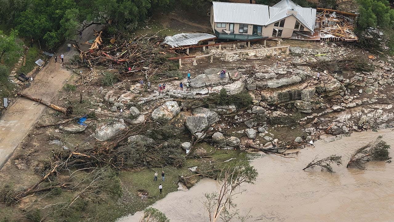
The morning after the Memorial Day flood, Mike and Gayla McNeil returned to their house. The roof was barely hanging on, and many of the exterior walls had caved in. The flood had filled the structure with ten and a half feet of water and left behind a foot of mud. The house was a total loss.
Two weeks later, a church friend demolished their ruined home, and the couple, who have been living in someone else’s home for the past year, started over. “We thought long and hard—wouldn’t it be easier to buy a house somewhere in town?” says Mike, who is a retired general contractor. Their home, which was built in 1940 and expanded in 1996, was well within the floodplain according to both the 1989 map and the new advisory map. But the McNeils weren’t deterred. “We’ve got a really nice piece of property here,” Mike says. “We decided to go ahead and rebuild.”
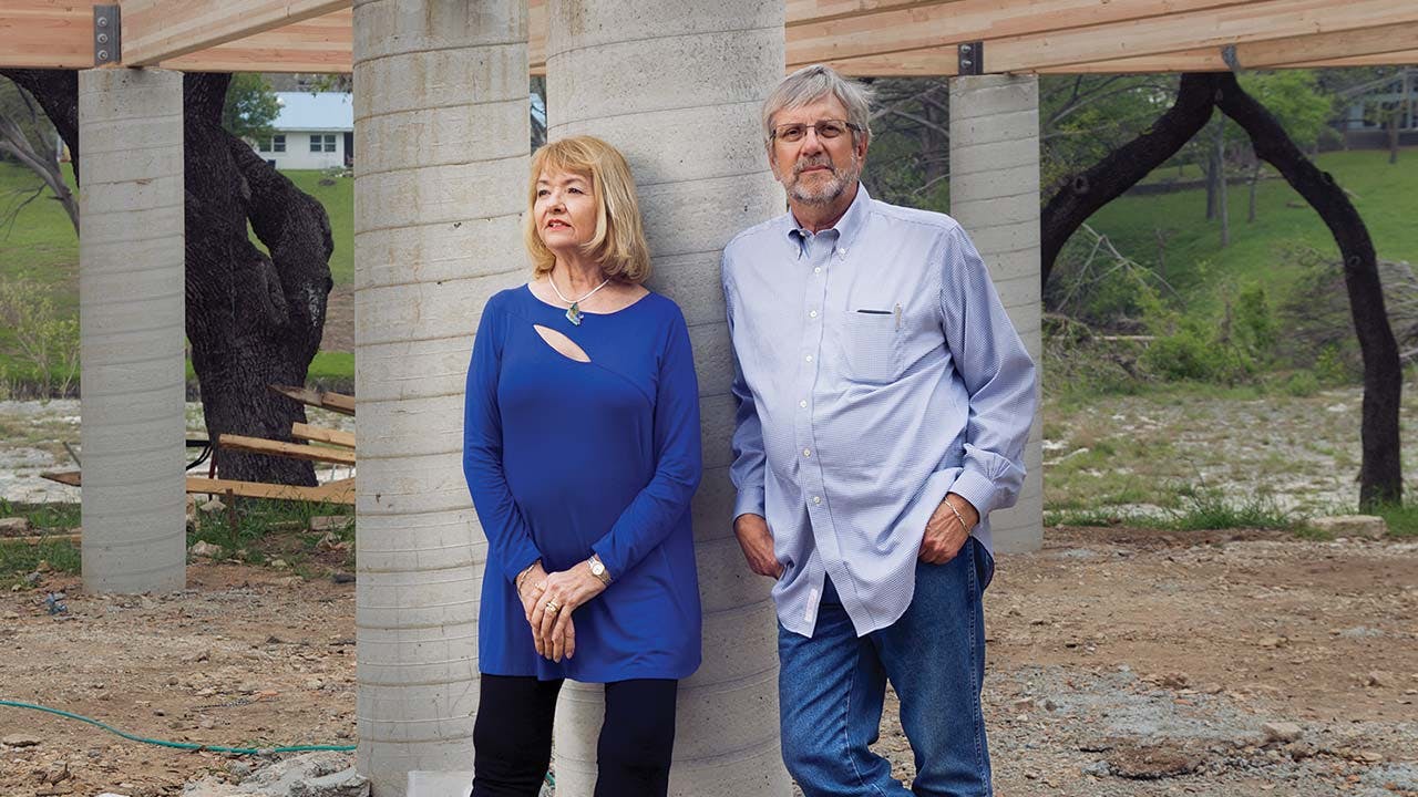
The McNeils are constructing their new home on the same spot as the old one, this time on sturdy steel-reinforced concrete piers that are drilled about fifteen feet into the earth and extend four to eight feet into the air. If they had decided to build in accordance with the advisory map, their home would tower fifteen feet off the ground. “We’d need an elevator to get to the front door,” Mike says. To withstand a future flood, they’re taking extra precautions, like bolting the floor beams to the pillars.
On a pleasant morning in March, the McNeils stood among their home’s newly dug concrete piers. Down below, the Blanco flowed past tree stumps and brush piles, and the roar and thrum of home renovations sounded from both sides of the river. Once they have moved into their new home, what will happen if a historic flood strikes again?
“We’ll have about three feet of water in the house,” Mike said.
“And,” said Gayla, “we’ll probably be in there.”


