
The cottontail was on a suicide mission, hopping onto the pavement just as I tucked into my racer’s crouch on the steep downhill of Bear Mountain, in West Texas. I was the last in a three-man parade stretched along Texas Highway 166, the state’s highest public highway, near the end of our two-day, 76-mile ride on the Fort Davis Scenic Loop. Now either this bunny was going to be roadkill or I was going to skid out on the cattle guards spanning the highway. Somewhere below me, my companions, Dennis and Alan, were speeding ahead. I was trying my best to catch them before they reached the Chihuahuan Desert floor.
Some consider the Davis Mountains, outside Fort Davis, to be the most stunning scenery in Texas, earning the region the well-deserved nickname the Texas Alps. For certain breeds of cyclists (read: fitness freaks and hard-core masochists), the high-altitude Scenic Loop, which follows Texas Highway 118 past Davis Mountains State Park to its intersection with Highway 166, where we hit speeds of over 30 miles per hour on that descent, offers a magnetic challenge. With four thousand feet in overall elevation gain, the ride’s promised rewards include the thrill of athletic achievement and the wonder of seeing Texas’s high lonesome up close.
“It’s just incredible,” says Jasha Cultreri, a cycling enthusiast and geophysicist from Midland, who chairs the Permian Basin Bicycle Association’s annual Cyclefest. A noncompetitive fundraiser for area emergency services, Cyclefest typically attracts as many as four hundred riders; it hosts its forty-second annual ride September 15 and 16.
In early summer, having spent years riding all kinds of bikes across all kinds of terrain—from the outskirts of Dallas, where a young Lance Armstrong once found success, to the hidden hills of the Rio Grande bottomland beyond Big Bend National Park—I wanted to see for myself whether the Fort Davis ride lived up to its billing. It was easy to enlist my friends Dennis and Alan after they heard about the extraordinary, if sweaty, adventure I envisioned. Over the winter, we launched a training program to prepare; they live in Austin and San Antonio, respectively, while Houston is my home, so we ride together only occasionally, but we often text our daily mileage back and forth. (For five other favorite rides across Texas, click here.)
Violent volcanic activity formed the Davis Mountains 35 million years ago. Like the forested flanks of the Chisos Mountains, in Big Bend, this tree-studded alpine environment is part of what scientists describe as a sky island, which is a cooler, wetter landscape surrounded by arid lowland desert, making it one of Texas’s more unique wildlife habitats. Bears, mountain lions, and birds all proliferate here. Thanks largely to the Nature Conservancy, which owns the 33,075-acre Davis Mountains Preserve (including Mount Livermore, the tallest peak in the range, and Madera Canyon), more than 100,000 wildland acres have been protected from development.

For travelers, that means that once you leave the cozy confines of historic Fort Davis—which, at a little over five thousand feet above sea level, is the highest town in Texas—you won’t find billboards blocking the exquisite views. Traffic is virtually nonexistent, and even the drivers of dually pickup trucks swing wide to provide riders safe passage on the narrow shoulders. Between the parklands, preserves, ranches, and public picnic grounds, of which there are many, cyclists can enjoy unspoiled vistas aplenty and primo wildlife viewing.
Wanting to make the most of the trip, which required the long drive to our West Texas rendezvous, I planned a two-day itinerary and booked us a modest cabin in Fort Davis. In deference to the June heat, we rode out early each morning to finish by lunch. Our first pedal covered thirty-plus scenic miles in Limpia Canyon, where alligator juniper and piñon pine shade Highway 118; our second day dropped from high passes beyond the telescope-topped Mount Locke, sailing us onto the high plains. Dennis’s wife, Debi, joined us for the first day of the cycling journey, while my wife, Christina, provided shuttle service to and from the junction of highways 118 and 166, which overlaps the Texas Mountain Trail, one of ten scenic driving routes that are part of the Texas Heritage Trails Program.

Steep Chase
During Cyclefest, serious riders prove their mettle on the 6,791-foot-high Mount Locke Hill Climb. They can start either from near Prude Ranch, for a 7-mile suffer fest, or from the gates of the McDonald Observatory, for a 1.5-mile blast.
Some might argue that a bicycle is an imperfect conveyance to the high country of West Texas, but on day one, as we passed the horse corral at historic Prude Ranch (which is the Cyclefest start and finish line), I reminded myself that modern highways across America often follow ancient footpaths. In turn, as my thighs began to burn on the near-constant climbs, I held tightly to the idea that, until 1947, when the loop’s construction was complete, many travelers used muscle power as I was doing now.
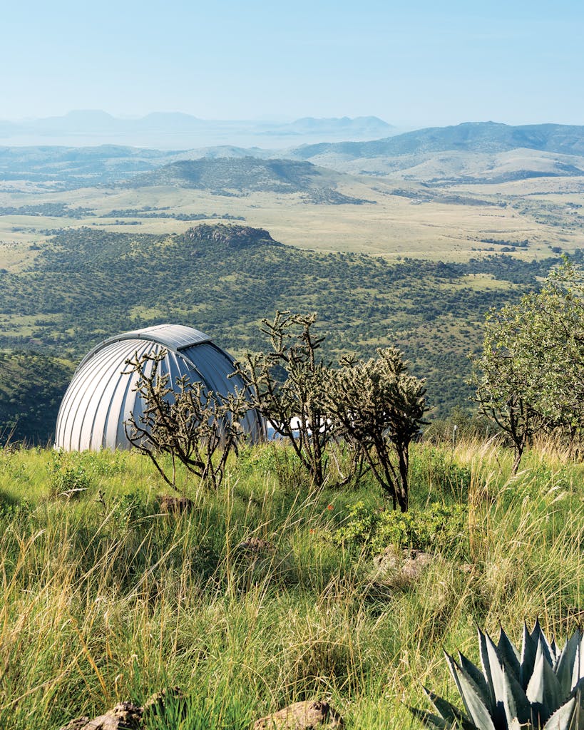
At mile eight, after we passed Davis Mountains State Park, the gleaming white telescope silos of the McDonald Observatory, the University of Texas research facility, became visible on the high ridge. The park has more than 2,700 acres, not to mention the picturesque Skyline Drive Trail. I made a note to visit the park at a later date. The ranger outpost warned of mountain lions in the area, but we didn’t see any on our tour, though we did encounter roadside javelinas. Already breathing hard in the midmorning sun, when we approached Spur 78, which leads to the observatory, we opted out of making the infamously steep 1.5-mile Mount Locke climb (although we did drive up on our last night for the observatory’s famous Star Party, a tour of the night sky constellations via telescope).
As we pedaled on, we encountered some of the damage from this year’s fires, which were sparked by lightning storms and spread to portions of Madera Canyon. Almost 40,000 acres burned across the area, including 3,000 acres of Nature Conservancy land, searing the forest understory along the highway. We also spotted draglines used in an effort to help slow the spread of fires along Highway 166.
Still, we concluded day one in fine fettle, Dennis having led the way for the first 31 miles, with me in second place, Alan following, and Debi bringing up the rear. “I am so happy we get to do this,” Alan crowed. “I can’t believe how friendly everybody is. They steer all the way around. This is really amazing country.”
Rested, we returned the second morning to the high country and set off—sans Debi, who preferred the shady woods to the rough desert lands we were about to face. We three pedaling musketeers, though, were committed to the full 76 miles, and soon we were underway, skirting the towering rock piles pointing toward the incomparable looming teeth of Sawtooth Mountain, rising 7,686 feet above sea level. Although smaller than Mount Livermore, which stands at 8,378 feet, Sawtooth is a jaw-dropping Texas peak.
About which time Mr. Bunny made his appearance, first hopping left and then right. In the absence of a horn to lean on, I started bellowing, and after ten yards or so, he blasted off into the woods, leaving me to finish my ride. I arrived in Fort Davis, dead last, to find my friends, happy to share bragging rights and a well-deserved cold beer.
- More About:
- Cycling
- Fort Davis


