

West of the Pecos everything shifts. The landscape gives up any pretense of being nurturing or pleasant, and the creatures that survive amid these harsh rocks tend to be prickly and self-sufficient (though most of the humans, at least, can be kind and generous). Mountains slash across the desert like knife scars, but in fact they are the crumbling bones of the world, connected to the Rockies, the Ozarks, and Mexico’s Sierra Madre. Locals will tell you that “everybody out here turns to Jesus or alcohol eventually.” But I am continually drawn back to these wild heights, where nothing comes between you and whatever is in your soul.
Texas has more than forty mountain ranges, all of them located in our eight westernmost counties. But because more than 90 percent of land in the state is privately owned, the vast majority of them are enjoyed by only a select few. Just seven Texas ranges have easily accessible areas. Still, that leaves plenty of peaks for those of us who don’t own our own mountains. Over the years, I’ve developed a list of my favorite activities, tailored to the best one or two things to do in each range, whether it’s hiking, horseback riding, rock climbing, gliding, or cattle driving.
But whatever I do in them, Texas mountains have a way of clearing my mind. When James Boswell told Samuel Johnson that it was impossible to refute the doctrine of nonexistence of matter, the doctor famously responded by kicking a stone and pronouncing, “I refute it thus.” When life weighs too heavily, I find that removing myself to a distant mountaintop in West Texas allows me to look the absurdities of the world in the eye and say to them, “I refute you.” Out here the clock still runs a little slower and you can find some of that increasingly rare gift, time savored in the presence of natural splendor.
Guadalupe Mountains
Location: Northwestern Culberson County, 110 miles east of El Paso on U.S. 62/180
Highest point: Guadalupe Peak (8,749 feet)
Geology: The Guadalupes are a chunk of the large horseshoe-shaped Capitan Reef, which formed 250 million years ago in the Permian period, when this area was the bed of a tropical ocean. This lump of limestone was thrust up during the Laramide orogeny, a 30-million-year-long tectonic event that also gave birth to the Rockies.
Resources: nps.gov/gumo; 915-828-3251.
To stay: Camp at the Pine Springs or Dog Canyon campgrounds for $8.
Tip: The short Pinery Trail at Pine Springs is a great way to get up to speed on desert flora; signs identify various shrubs and trees that grow along the path.
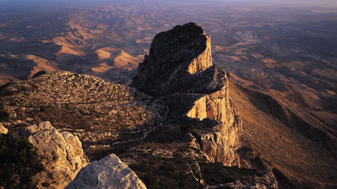

A view of El Capitan from Guadalupe Peak. Photograph by Laurence Parent
There are more than eighty miles of trails and eight of Texas’s tallest peaks in the 86,000-acre Guadalupe Mountains National Park, the only officially designated wilderness in West Texas, which makes this the place for some high lonesome hiking. If it’s still on your Texas to-do list, make the popular trek up to Guadalupe Peak, the highest point in the state, and like the captain of an ocean liner, gaze over the jutting prow of El Capitan at the empty ranchland three thousand feet below you.
Most of the trails that begin at Pine Springs (park HQ) go the other direction, north toward New Mexico, fanning out and then converging at the campsite in the remote and beautiful Dog Canyon. Hiking there takes a couple days along the transmountain Tejas Trail (there are several backcountry campsites along the way), which begins with a grueling ascent to the Bowl, a forested lost world hidden behind the pine-tree-dotted ridges of Hunter Peak. Lovely as this is, I prefer to drive straight from Pine Springs to Dog Canyon and make my base camp there. On the way, you can visit the must-see Carlsbad Caverns and cool off in Sitting Bull Falls (off New Mexico Highway 137).
From Dog Canyon I like to make the round-trip to Bush Mountain, an all-day exercise in stamina and solitude that follows the western edge of the range, or hike up to McKittrick Ridge for a view into McKittrick Canyon. Although wind gusts of up to 100 miles per hour can make it difficult to enjoy, particularly in the spring, this vista is always one of the most beautiful in Texas. A winter snowfall can turn the forests into a real-life Narnia, and in October the maples paint the valley below red, orange, and yellow.
Hueco Tanks
Location: El Paso County, 32 miles northeast of El Paso, 4 miles north of Texas Highway 62 on Ranch Road 2775
Highest point (in the hueco mountains): Cerro Alto (6,787 feet)
Geology: The Hueco Mountains are a classic Texas fault-block range, in which areas of bedrock are tilted by the stretching of the earth’s crust to form escarpments known as horsts. West of this fault line is the Hueco Bolson, and at the north end of the Bolson is the porphyritic syenite intrusion known as Hueco Tanks.
Resources: tpwd.state.tx.us/spdest/findadest/parks/hueco_tanks; 915-857-1135. (Self-guided access is limited to seventy people at one time, so a reservation is recommended. Check the calendar page for tour dates.)
To stay: There are campsites and RV hookups in the park, but it’s more fun to hang with the climbers at the Hueco Rock Ranch (huecorockranch.com; 915-855-0142), where a tent site is only $5 a night.
Tip: If you haven’t visited in the past year, allow yourself an extra half hour to view the Texas Parks and Wildlife mandatory orientation video.
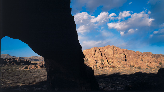

A view of Hueco Tanks. Photograph by Laurence Parent
Hueco tanks, the remains of a granite dome, lies on a dusty desert in the shadow of the Hueco Mountains. Over eons, the surface of the dome cracked and split into loose boulders, as though some lazy Hercules had swept the plateau’s debris into three untidy piles. The result is perfect for that most exhilarating of mountain sports: rock climbing. But Hueco Tanks has always been treasured for more than that. Thousands of years ago the climate here was much cooler and wetter; as the land slowly turned to desert, the water that collected in the huecos, or hollows, in the boulders became increasingly precious to the tribes who traveled through the area, and the Tanks came to be considered a sacred refuge. In addition, generations of inhabitants left behind an archaeological and artistic treasure trove in the form of thousands of rock paintings, including more than two hundred images of masks from the prehistoric Jornada Mogollon period, the largest collection in the country. Today there’s an uneasy truce between libertarian rock climbers and conservationist groups, who’d like most of the site to remain off-limits to casual visitors.
But with caverns and crevices and green valleys full of twittering birds—where you might also glimpse a bobcat, as I did on a recent misty morning—Hueco Tanks cries out to be explored. Mountain lions have been seen here; gray foxes, prairie falcons, and golden eagles are common. Snakes love the shady cracks in the rocks, so be careful as you clamber around. You can wander freely over North Mountain, but to experience the best of the park, you need to take one of the official tours: Choose Hiking and Bouldering, Birding, or Pictographs. If you want to climb East and West mountains or the East Spur (the guided areas), you can ask to be accompanied by a volunteer or contact the folks at Hueco Rock Ranch, who have lots of information on park access and run commercial climbing tours to these areas.
Climber’s heaven, sacred site, archaeologist’s dream, nature lover’s paradise—Hueco Tanks is all these things. Just remember to play by the rules: Watch where you put your hands and feet, respect the past and the present, and climbers, please, no tick marks.
Franklin Mountains
Location: El Paso
Highest point: North Franklin Mountain (7,192 feet)
Geology: The Franklins, which are the southernmost end of the Rockies, are a complex mix of sedimentary Precambrian and newer igneous rock spanning 1.25 billion years.
Resources:
Franklin Mountains, tpwd.state.tx.us/spdest/findadest/parks/franklin; 915-566-6441. Wyler Aerial Tramway, tpwd.state.tx.us/spdest/findadest/parks/wyler_aerial_tram; 915-566-6622.
To stay: After securing a permit at the state park headquarters, camp at the Tom Mays Unit for $8 a night. A word of warning: Most of the tent sites are a few hundred yards from the parking lot, so pack lightly. Site number five is by far the closest.
Tip: Feeling adventurous? Hike the tough Ron Coleman Trail, along the spine of the Franklins, from McKelligon Canyon to Transmountain Drive.
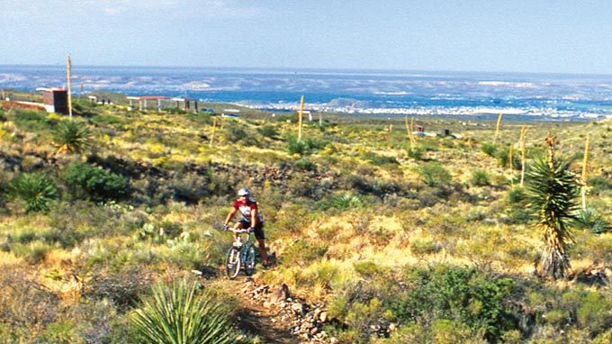

Biking on one of the many rugged paths in the Franklins. Photograph by Laurence Parent
Surrounded by city streets, traversed by a vast highway, crisscrossed by mountain bike trails—if there’s a range that can be enjoyed from either two or four wheels, it’s the Franklin Mountains. They bask in the desert sun like a big lizard, its nose in downtown El Paso and its tail stretching lazily into New Mexico. From this creature’s high back the bustle of the transborder metroplex seems a long way away, but most of the range—37 square miles of it, still the largest urban park in the U.S.—is within El Paso city limits, so it seems right to start your tour in a car in the urban neighborhood around the nostrils and work up to the spine. The route I recommend: From North Mesa, take East Robinson Avenue northeast, continuing as the road makes a sharp right turn at the foothills and becomes Scenic Drive. At the southernmost tip of Scenic Drive—4,000 feet above sea level—pull into the viewing area and study the twin cities through one of three funny-face long-range binoculars. Not that you need them to read the message (“La Biblia es la verdad. Leela”) spelled out in white stones on a hillside above Juárez. (Gerardo Bermudez, a Mexican preacher, made the sign in 1987 with the help of his parishioners.) Then follow Scenic Drive north, along the eastern edge of the range. Turn left at Alabama and left again onto McKinley Avenue, which zigzags up the mountainside to the Wyler Aerial Tramway. Ride the tram to Ranger Peak, 5,632 feet above sea level. From there you can see all of El Paso and Juárez and, depending on the visibility, many square miles of Texas and New and viejo Mexico.
When you’re ready, drive back down and take a left on Alabama, then follow Fred Wilson Avenue to Texas Highway 54 North. Take the exit for Woodrow Bean Transmountain Drive and head over the pass to the Tom Mays Unit. The Franklins offer a spectacular variety of rock climbing and hiking opportunities, but I recommend you park your four-wheeler and bike down the fifteen-mile Lower Sunset Trail, a cactus-strewn track with a tough hill at the finish (don’t do what I did, which was fly over my handlebars onto a rattlesnake lying in a prickly pear). Or head outside the park to Monk’s Trail (at the eastern end of East Robinson Avenue), thirteen miles of steep technical mayhem up Crazy Cat Arroyo, and Puzzler Trail (north of Fort Bliss; see the Google Map at bit.ly/JCXFP), which loops up into New Mexico and back.
Davis Mountains
Location: Fort Davis, Jeff Davis County
Highest point: Mount Livermore (8,378 feet)
Geology: The Davis Mountains were formed about 35 million years ago during a period of intense volcanic activity when the ten-mile-wide Paisano Volcano erupted and then collapsed; they feature totemlike formations of rhyolite, a fine-grained granite.
Resources: Nature Conservancy, bit.ly/lyov4. Fort Davis Stables, fortdavisstables.com; 800-770-1911. McDonald Observatory, mcdonaldobservatory.org; 432-426-3640. Marfa Gliders, flygliders.com, [email-hidden]. Padre’s, padresmarfa.com; 432-729-4425.
To stay: Go historic and reserve a room at the Hotel Limpia, in Fort Davis (on the town square, 432-426-3237), or the Hotel Paisano, in Marfa (207 N. Highland, 432-729-3669).
Tip: Find an hour or so to admire the botanical specimens and learn more about the local ecology at the Chihuahuan Desert Research Institute, just outside Fort Davis (cdri.org; 432-364-2499).
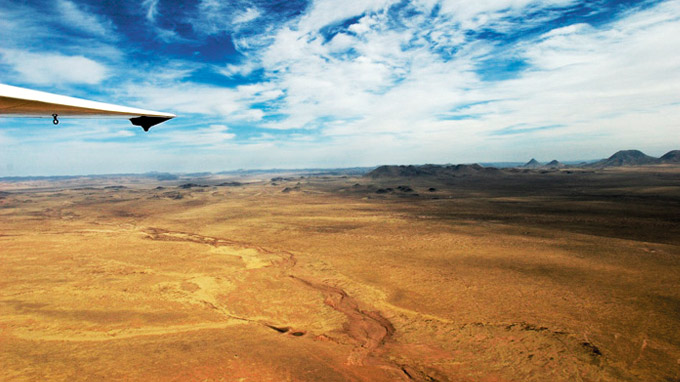

A view of the desert from a glider. Photograph by Charlie Llewellin
These mountains are the angel food cake of the Texas ranges, an airy confection of pinkish rock laced with ribbons of bright green where cottonwood-lined creeks run through steep canyons. Fortunately or unfortunately, depending on your opinion, most of them are privately owned. The highest points, on Mount Livermore, are part of the Nature Conservancy, which doesn’t make it particularly easy for nonmembers to get access. But there are a couple ways to enjoy stunning views both from and of these mountains, and, even better, neither method requires much work from you.
The first option is to ride. Fort Davis Stables organizes horseback adventures onto Conservancy land, saving you the hassle of getting permission (or being caught trespassing, like me). Your horse will take you all the way to Mount Livermore, though you’ll have to scramble up the last few hundred yards if you want to enjoy the West Texas panorama visible from the actual top, Baldy Peak. The stables also offer shorter rides onto the historic Sproul Ranch, which runs along Texas Highway 118 all the way to the University of Texas at Austin’s McDonald Observatory, where for $10 you can gaze up into the darkest, starriest skies in the country.
To get a once-in-a-lifetime bird’s-eye view of the Davis Mountains (and many others), you’ll want to visit Marfa Gliders. Moist air from the Gulf mixes with the dry desert air to create strong thermal uplifts and exceptional gliding conditions—and an incredible aerial experience. From the aircraft, Marfa is just a tiny spot on a vast rug of brown grass ringed with dark Mordor-like ranges. Burt Compton, the pilot, will identify these surrounding peaks, and afterward, when you’re back on the ground, he’ll take you around his collection of gliders, where you can admire the vintage Ludwig drum kit set up in the hangar. Compton’s band, the Moondogs, often plays at Padre’s, Marfa’s hip new bar, and there you can regale travelers less bold and rugged than you with tales of your Far West adventures.
Chinati Mountains
Location: Near Shafter, forty miles south of Marfa, in Presidio County
Highest point: Chinati Peak (7,728 feet)
Geology: Formed during the same period as the Davis Mountains from layered igneous and metamorphic (which means transformed by heat and pressure) rock, the Chinatis are a prime example of the “infinite diversity in infinite combinations” (as Spock might say) caused by massive vulcanism.
Resources/To stay: Cibolo Creek Ranch, cibolocreekranch.com; 432-229-3737. Chinati Hot Springs, chinatihotsprings.com; 432-229-4165.
Tip: For a small fee, Hot Springs manager Krissy Sines will fetch groceries for you from Presidio and Ojinaga.
A view of the Chinatis. Photograph by Laurence Parent
On a recent visit to Fort Leaton, near Presidio, I was stunned to see a map of the long-anticipated Chinati Mountains State Natural Area. In 1996 Texas Parks and Wildlife was given 40,000 acres in the Chinatis, but the area—a holy grail for lovers of the Texas high country—has remained closed to the public. Alas, access problems and a lack of funds mean that there is still no planned opening date. When that blessed day comes, you’ll be able to climb to the top of Chinati Peak. Until then, the only part of the range that a humble hiker can explore is within the grounds of the extremely swanky Cibolo Creek Ranch. So I took it upon myself to stay at this high-end resort, to see what I could of the range on a mountain bike. (You don’t even have to bring your own, by the way, since they have a stableful. I told you! Muy swanky.)
I pedaled my way across a couple miles of grassland into the mountains proper, following one of the ranch’s jeep trails. These tracks wind past such points of interest as Indian caves and pictographs, old camps and corrals, and several scenic overlooks, from one of which you can see across the Rio Grande into Mexico. Along Cibolo Creek itself the leaves were a fresh green, and there were birds everywhere. The light seemed cleaner and brighter than in other ranges, though the ranch’s excellent food and wine and very comfortable bed—not to mention a shower—might have had something to do with that. (For the bike-averse, alternative transport options include Humvees and horses.)
The next day, having neglected to prebook a massage, I decided to seek relief for my sore muscles at Chinati Hot Springs, which is kind of like Cibolo Creek’s hippie cousin. Located seven miles south of Ruidosa on Hot Springs Road, down at the bottom of FM 2810, the remotest and most scenic road in Texas, the springs are the sweetest, funkiest place to unplug you’ll ever find, instantly inducing a complete detachment from normal life. (When I was there in April, I met a man from Dallas who was camping with his big black dog, Jack. When I checked back in June, Jack and his master were still there.) The resort is nothing but a few brightly painted cabins (some with spring-fed bathtubs) hidden in an arroyo, a communal hot tub, and a swimming pool from which you can see the Sierra Madre. The place is owned, oddly enough, by a former Tyco executive and is presently for sale, which is why I’d appreciate it if you could lend me a million and a quarter dollars right now.
Bofecillos Mountains
Location: Southwestern Brewster and southeastern Presidio counties, twenty miles southeast of Presidio
Highest point: Oso Mountain (5,137 feet)
Geology: The Bofecillos are the remains of an extinct volcano, composed primarily of conglomerate sandstone, tuff, and basalt and featuring great examples of tertiary volcanic activity.
Resources: Big Bend Ranch State Park, tpwd.state.tx.us/spdest/findadest/parks/big_bend_ranch; 432-358-4444. Lajitas Stables, lajitasstables.com 800-887-4331.
To stay: You can find a bed and shower at Sauceda Ranger Station, but to fully experience these rugged parts, camp at Guale 2, a site on the edge of Rancherias Canyon. Though it took me a nail-biting hour and forty minutes to drive there, the canyon offered a view that I’ll never forget.
Tip: Get supplied at the Thriftway in Presidio, which, although it still caters to the Pepsi and Doritos crowd, has quietly expanded its offerings to include—!—organic produce.
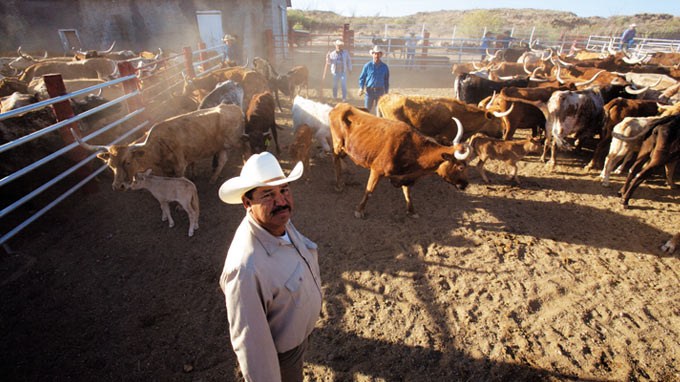

Head cowboy Ruben Hernandez at Sauceda Ranger Station. Photograph by Charlie Llewellin
There are no easy trails to obvious peaks in the Bofecillos. The attraction is the rough and rugged landscape and the chance to witness man’s struggle with the harsh environment: This grand but intimidating sweep of rocks is littered with the detritus of our attempts to tame it—impossible fence lines, rusting machinery, and abandoned stone cabins. The 300,000-acre ranch was acquired by Texas in 1988 and is now a state park. Though a two-year public use plan has improved accessibility to the park’s hinterlands, this is still the backcountry, with some of the ruftiest-tuftiest public thoroughfares in the state. What you need to get around this forbidding landscape and unlock its many surprises—waterfalls, spectacular canyons, hidden creeks—is a good horse.
You can find one at Sauceda Ranger Station, the park’s headquarters, which is still a working cattle operation and the home of a registered Longhorn herd. Head cowboys Ruben Hernandez and Raul Martinez lead rides to legendary beauty spots such as Baños de Leyva and Cinco Tinajas, and they also quarterback the famous biannual Longhorn Cattle Drive. Hernandez, who was born in a village across the Rio Grande and has worked here most of his life, knows everything there is to know about the ranch. For three days participants help him and Martinez scour washes and creek beds for scattered cattle, round them up, and drive them to Sauceda for branding and vaccinating, earning their supper and sleep in the process of learning what it really means to be a cowboy (and yes, they get to wear chaps).
In the nineteenth century, prospectors discovered mercury and silver here; they left the desert littered with abandoned mines. You can experience this aspect of the area’s history by calling Linda Walker’s Lajitas Stables and booking the Buena Suerte ride, a two- or three-day expedition to the eponymous abandoned mining village and to Fresno Canyon. (Just last year the state acquired most of Fresno Ranch, meaning that you can now follow Fresno Creek all the way to the Rio Grande.) Kent Potter, an Alpine cowboy whose knowledge of the area’s geology and past is second only to his skill as a chef, guided the group I joined. I felt very close to heaven lying under the stars after a day riding through beautiful scenery and a supper that included the best beans in Texas.
Chisos Mountains
Location: Big Bend National Park, southern Brewster County
Highest Peak: Emory Peak (7,835 feet)
Geology: The Chisos are mostly igneous rock formed roughly during the same geological remodeling spree that created the Davis and Chinati mountains. The Big Bend area marks the boundary of the Ouachitas (an ancient eastern mountain range) with the newer western Laramide system.
Resources: nps.gov/bibe; 432-477-2251.
To stay: Cabin 103 at Chisos Mountains Lodge (chisosmountainslodge.com; 877-386-4383) has the only unobstructed view of the Window but is often booked up to a year in advance.
Tip: The Lodge’s restaurant improved dramatically when Forever Resorts took it over and is now well worth a visit.
The view from Lost Mine Trail. Photograph by Laurence Parent
The jagged ring of the Chisos Mountains, the southernmost mountain range in the U.S. and the only one to be fully contained within a national park, is probably the state’s best-known natural landmark. Every year 350,000 people, most of them Texans, drive out to the Chisos Basin to hike along the paved Window View Trail and watch the sun set between Amon Carter and Vernon Bailey peaks. But that’s not to say the Chisos are too crowded or predictable. On the contrary, they offer rigorous—and jaw-droppingly beautiful—hiking in one of Texas’s most biodiverse regions.
Day hikes, like Lost Mine Trail, the South Rim, and Emory Peak, are justly popular, but they don’t really give a sense of the amazing ecological transition from desert to mountain. The best way to experience this is to hike Juniper Canyon Trail. Make your camp at Robber’s Roost or Twisted Shoe. The route begins with a long slog along the desert floor before ascending steeply to a forested pass under Townsend Point. From there it continues around Toll Mountain and up to the top of the Chisos. As you climb, look out for rare birds, like the Colima warbler and Mexican jay, and unusual orchids, such as the saprophytic coralroot or the Hidalgo ladies tresses. By the time you reach Emory Peak, there’s a good chance you’ll be walking through cool, misty clouds—even if it’s more than 100 degrees down at your campsite. From there, you can enjoy the best view in Texas—out over the rim of the range and across the desert for hundreds of miles in every direction. In the course of nine miles or so you’ll have gained four thousand feet; by the time you’re back at your tent, I bet you’ll have lost roughly the same number of pounds.
Although none of the other ranges in Big Bend are quite as noteworthy or as accessible, the park’s expanses are an open invitation to more-experienced adventurers. You can camp almost anywhere, and though the views may be less dramatic, you won’t have to share them with anybody. (I’m certain that fewer than ten people climb Rosillos Peak each year.) For starters, try the eleven-mile Dodson Trail through the scorching Sierra Quemada, or Burned Mountains, which are the southern foothills of the Chisos; this trail joins Juniper Canyon Trail to form part of the Outer Mountain Loop, a thirty-mile trek that usually takes three days. The most remote (and maybe toughest) trails in the park are Strawhouse and Telephone Canyon, which go up into the secret peaks of the Sierra del Carmen and Sierra del Caballo Muerto. Camp at one of the sites along Old Ore Road, a four-wheel-drive trail that passes points of historical interest, like an ore tramway, as well as natural features like Ernst Tinaja, a rock pool that is one of the few reliable water sources for wildlife.


