

We need wilderness preserved—as much of it as is still left, and as many kinds—because it was the challenge against which our character as a people was formed,” wrote Wallace Stegner in 1960. In his now famous “Wilderness Letter,” the Pulitzer Prize–winning author was addressing the Outdoor Recreation Resources Review Commission, a newly formed body whose mandate from Congress was to identify and help protect public recreational areas. It was a time of growth in America, and nature was in retreat: a proliferating highway system was ferrying automobiles all over the land, forests were being felled, wild rivers were being dammed. Stegner, whose love of land had been shaped by a childhood in the West, implored the commission to preserve the country’s wild spaces as a collective spiritual resource.
Stegner did not specifically address Texas in his letter, but his eloquent case for wilderness as a piece of our identity surely resonated four years later in the mind of one particular Texan, Lyndon B. Johnson, when, as president, he signed a law that revolutionized America’s relationship to its wild spaces. The Wilderness Act of 1964, supported almost unanimously by Congress, gave 9.1 million of the country’s unspoiled acres immediate protection and provided for the future preservation of additional land (there are more than 105 million acres of protected wilderness today).
As Johnson stood in the White House Rose Garden almost exactly fifty years ago to announce the passage of these new protections, he likely had images of lush Oregon forests and pristine Alaska rivers running through his mind. But might he also have been thinking of the Hill Country he grew up in—that wild frontier land his grandparents had once shared with the Comanche? Of limestone escarpments and Spanish oaks and Indian paintbrush? No doubt.
The act defines wilderness as “an area where the earth and its community of life are untrammeled by man,” and in Texas, as any nature-lover can tell you, finding such areas is often a tall order—because for all of our land, very little of it has not been trammeled. Though we do have some 37,000 acres of federally designated wilderness (most of it concentrated, perhaps counterintuitively, in East Texas rather than out west), that is a paltry amount when you consider that our privately owned land—farms, ranches, forestlands—makes up 142 million acres. So what is a wild man or woman to do? How to escape the tyranny of exhaust fumes and pinging smartphones and go where we can experience, as Stegner put it, “the spiritual renewal, the recognition of identity, the birth of awe”?
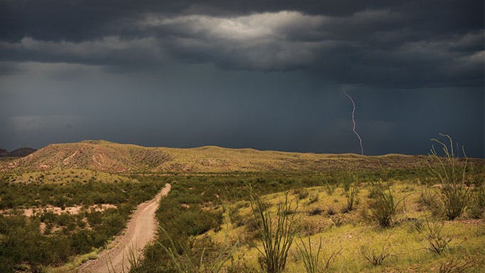
Fortunately, Texas does not lack for wild places. There are corners like the Devils River or Palo Duro Canyon or McKittrick Ridge, which, despite human footprints, remain savage—where you are at the undeniable mercy of weather and wildlife, and where no amount of book-learning or web-surfing (um, not that there’s Wi-Fi out there) can spare you from trouble. There are also spots like Goat Island or Sabal Palm Sanctuary, where the primordial diversity of the flora and fauna restores your sense of place in the natural world. And there are sites like Boquillas Canyon, where a slow float down the Rio Grande inspires thoughts of the transcendent and reveals the stars as you’ve never seen them. Even certain swaths of private land, like the King Ranch or Pinto Canyon, so unpopulated that they are by definition wild, allow for exploration if you go about it the right way.
But you have to know what that way is. With this in mind, we recently sent Houston travel writer Dan Oko on a months-long quest to unearth fourteen destinations where Texas still reveals itself in all of its gloriously unrestrained wildness. Four other writers—Rick Bass, Matt Bondurant, S. C. Gwynne, and Kate Murphy—each endeavored to wander into the wild in some fashion as well. Broadly speaking, these places are gnarly—no water, no services, no cellphone reception—but they are also among the most beautiful, the most humbling, the most transformative.
“If future generations are to remember us with gratitude rather than contempt,” declared LBJ, “we must leave them more than the miracles of technology. We must leave them a glimpse of the world as it was in the beginning.” Let us linger over the following list, yearn for the wildness still in our land, and then go seek the dawn. —Katharyn Rodemann
No. 1 Dolan Falls
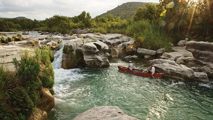
The Devils River has a reputation as the loneliest, prettiest, most dangerous, and best damn fishingest waterway in all of Texas. I’ll leave it to others to debate these superlatives, but here’s what I do know: coming upon this Caribbean-blue stream amid a rocky landscape that has barely changed since the era of the Comanche is a life-altering experience. Spend some time in its pristine waters, catch a couple of feisty smallmouth, and let the roar of Dolan Falls ring in your ears, and you will be charmed. You will also be intimidated.
And you will want to go back.
Of course, getting there is easier said than done, because the Devils River, a remote tributary of the Rio Grande that runs some fifty miles across the desert, offers very few points of access. One such point, and it’s a helluva rugged place, is the Devils River SNA, which lies at the crossroads of the Edwards Plateau and the Chihuahuan Desert. That’s where I made camp this past spring—on a flat site between two rising ridges of limestone—then hiked for about a mile down to the river, an inflatable kayak in my rucksack. After putting in, I paddled downstream about half a mile to Dolan Falls, where I stopped to clamber across some rocks and spotted a few bass suspended in the cascading current. Though water levels were relatively low, the falls still made a mighty roar; the torrent at the ten-foot drop pounded in my ears as I sight-cast to a cluster of smallies and used my fly rod to land some hard-fighting fish.
Around the river, I found several trails that cut through prickly pear and willows in the shadow of the limestone cliffs, and I learned that it’s worth visiting higher ground too: the 20,000-acre Del Norte Unit, a rolling expanse just east of the river, offers twelve miles of trails for hiking and biking. Texas Parks and Wildlife also recently acquired a second, 17,000-acre unit called Big Satan, which should inspire more superlatives when it opens to the public at some point in the future. What can I say? I’m ready to go back.
Getting There: From Del Rio, travel 45 miles north on U.S. 277, then turn left on Dolan Creek Road and go 22 miles to the Devils River SNA headquarters. (Open Fri–Mon, free. 830-395-2133. Many of the roads are rough gravel and feature low-water crossings, so use a high-clearance vehicle.) To canoe or kayak, secure a permit from park headquarters. To reserve one of the primitive camping sites ($10), call Texas Parks and Wildlife at 512-389-8900.
No. 2 Caroline Spring
A bearded man was busy trapping small birds in a cage. They were brown-headed cowbirds, brood parasites that leave their chicks to be raised in others’ nests. The man was Corbin Neill, the manager of Independence Creek Preserve, a 20,000-acre area about halfway between San Antonio and El Paso that’s owned by the Nature Conservancy. Strange as it was to find a conservationist snaring birds like this, Neill had a simple explanation: managing the cowbird population improves the reproductive rates of songbirds on the property, including those of the black-capped vireo, a shy and elusive federally protected species. He paused to release a red-winged blackbird that had mistakenly been caught, then turned his attention back to trapping cowbirds. Neill meant business.
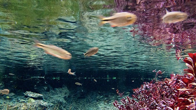
So does the Nature Conservancy. The preserve is one of 39 properties the national environmental group owns and manages in Texas, where its efforts have protected a landmass equal to the size of Rhode Island. Here, where the Hill Country gives way to Chihuahuan wilderness, juniper stands share canyons with desert scrub, while plateau grasslands help sustain whitetail deer, wild turkey, and quail. I saw this wildlife—and more—as I camped by the clear, cool waters of Independence Creek, but the real showstopper was Caroline Spring, whose five thousand gallons per minute feed the creek and recharge the Pecos River below. Thanks to a series of weirs, the spring also feeds an eleven-acre lake, whose emerald waters I found as intriguing as my lesson in bird population control.
Getting There: From Sheffield, travel 22 miles south on U.S. 349. Independence Creek Preserve is open to the public on select weekends only; go to nature.org/texas for dates. Registration required for campers. Free.
No. 3 Maravillas Canyon
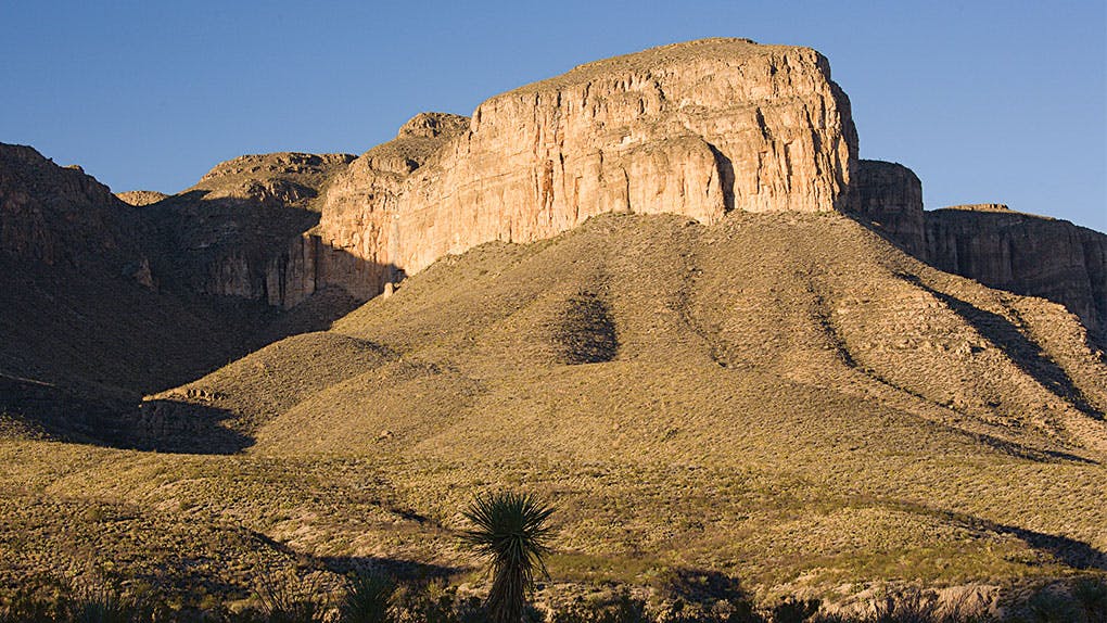
If you’re a solitude seeker, then the Black Gap WMA is paradise: it has no potable water, no bathrooms, no cell reception, and no other services. Located just east of Big Bend National Park, this sprawling 103,000-acre preserve, which includes a federally protected stretch of the Rio Grande, has served as a game research facility since it was founded, in 1948. But outside hunting season, the area has become a hidden playground for birders, mountain bikers, and fishermen. There’s a mix of primitive upland, hunting, and fishing camps and three hundred miles of unpaved jeep roads that beckon serious two- and four-wheeled explorers.
Though the area is generally uncrowded, it’s wise to register for a campsite—a piece of planning I realized I’d failed to do on a recent visit, when I arrived and began unloading my tent and mountain bike. Before I knew it, half a dozen anglers from Odessa with a claim on “my” space were descending with beer coolers, cots, boats, and their own expectations of privacy. Once or twice a year, one explained, he and his buddies caravan to this corner of the Trans-Pecos to pursue channel catfish. “It’s a damn ugly spot,” he snorted, hitching his pants over a prodigious gut. I grinned. He had to be joking.
But figuring these guys wanted no part of seeing me in spandex shorts, I beat a quick retreat. Swinging my leg over the bike saddle, I took off, chasing the shadows along a steep and rocky stretch of double track that undulated like the spine of a dragon. I passed signs marking the Desert Bighorn Experiment Area, where a celebrated reintroduction effort has brought bighorn sheep back to Texas. The strawberry pitaya were abloom, sprinkling the land with pretty pink flowers. On my way back to camp, Maravillas Canyon started to turn gold in the sunset, and my overheated brain turned the Spanish word—meaning “wonders”—over and over until it resembled a Billy Crystal routine: “Mar-rah-vee-yass.” Marvelous, indeed.
Getting There: From Fort Stockton, travel 98 miles south on U.S. 385, through Marathon, to FM 2627. Take FM 2627 about 17 miles to Black Gap WMA headquarters. From March 1 to August 31, access to Maravillas Canyon and the headquarters campground is restricted; during certain weekends the WMA is also reserved for public hunts. Always call ahead to verify hours and access (432-364-2228). All visitors must have either an annual hunting license ($48) or a limited-use permit ($12), available from Texas Parks and Wildlife.
No. 4 Boquillas Canyon
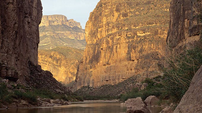
I scratched off the consummate trip on every outdoors-loving Texan’s bucket list—a catered float down Santa Elena Canyon on the Rio Grande—a few years ago, so this spring I returned to Big Bend National Park to tackle the longest and deepest of its canyons, Boquillas. The eighteen-mile chasm runs more than twice the length of Santa Elena, while its waters take you beyond the park’s eastern limit, cutting through the Dead Horse Mountains as they pick up volume.
I decided to forgo the service of a guide, instead inviting a friend who knows me well enough to check the Internet before trusting me with logistics. We agreed on a three- day, 33-mile float to the take-out at La Linda, an old mining bridge that once served as a border crossing, and launched our canoe at the park’s RV-friendly Rio Grande Village. Suspended sediment had turned the water into a beige, chocolate-swirled gruel, but as occasional carp slapped the surface and cliff swallows dived and darted from their nests, I felt myself gradually pulled in, much like the elephant who went looking in the “great grey-green, greasy Limpopo River” in Rudyard Kipling’s Just So Stories.
As the day wore on, we came upon landmarks such as the towering Lizard Rock and the Rabbit Ears formation, as well as other strange, unnamed monuments. Overhead, golden eagles harassed turkey vultures, and just past the park’s boundary, we began to hear feral burros, their brays bouncing off the rocks. That night, after paddling about ten miles, we camped on one of the sand beaches near a nameless side canyon and listened as their exotic serenade continued. It was hard to sleep, but with the glowing Milky Way above us, we didn’t feel like closing our eyes anyway.
Our only real challenge took place the following evening, after our second day in triple-digit heat, when a killer desert wind struck up during dinner prep. We’d set up on a well-used bank—Mexican vaqueros, or perhaps smugglers, had left a fire pit and a few flattened beer cans—when gusts of more than 40 miles per hour roared around us, mashing our tent and scattering our supplies. The wind silenced the burros—though only for a little while. Sipping gritty coffee the next morning, I heard their braying again, and it sounded like laughter. Another Just So story in the making.
Getting There: From Fort Stockton, travel 126 miles south on U.S. 385, through Marathon, until you reach Big Bend National Park headquarters. (Open 9–5 daily, $20 per vehicle. 432-477-2251.) To reach Rio Grande Village, take a left and continue for 20 miles. Numerous local outfitters provide equipment rental and guide services; we used Desert Sports, in nearby Terlingua (888-989-6900). Canoes rent for $50 for the first 24 hours, $45 for each additional day; shuttle services range from $110 to $255. You will need a $10 backcountry permit for camping, and you must secure permission to take out at La Linda from the landowners at Heath Canyon Ranch (432-376-2235).
No. 5 River Road
The aoudad ewe poked her head above the thorny mesquite and waving ocotillo, watching as I plodded up toward the ruins of Mariscal Mine. Then the shaggy-bearded goat, a sandy-brown species native to the mountains of North Africa, ducked out of sight. I felt the impulse to double-check where I was. Big Bend National Park, with its desolate tawny mountains and surprising wildlife, can be disorienting like that.
I was still just a short hike from my SUV—phew. A day earlier, I had set out to explore River Road, an unpaved route of almost 51 miles that cuts across the park’s remote southern backcountry. The rugged non-highway roughly parallels the Rio Grande, crisscrossing creosote-dotted washes, ashy deposits, and ancient lava flows, and it is not without its dangers, as the park ranger repeatedly warned me: a road explorer may encounter wild animals, flash floods, and even horseback-riding ladrones from across the border, who have recently been divesting unattended vehicles of camping gear and electronics. And with spotty cell service throughout the park, it’s not like help is readily available. Since I was driving alone, the ranger admonished, I was not to stray far from my vehicle.
Of course, this made the odyssey all the more irresistible. From one end to the other, the drive takes a full day, but after assessing the perils—it hadn’t rained in weeks, and the thieves appear to avoid personal contact—I decided to stretch my journey out over three days, driving, stopping to explore when the whim struck, and camping at the primitive gravel sites along the way.
I did secretly hope to spot a mountain lion—though, if I was being honest, preferably from the safety of my car. Then again, watching the world from behind my windshield was not the experience I had already driven ten hours from Houston for, so about twenty miles in, I ventured to what’s left of Mariscal Mine, a picturesque if eerie collection of ruins that sits amid a series of ravines. Beginning in the early 1900’s, the mine’s workers smelted the reddish cinnabar ore that stains the base of Mariscal Mountain, producing 42 tons of mercury over four decades. They helped fuel munitions manufacturing for the U.S. military, but near the end of World War II, the American quicksilver industry collapsed, and so did the mine’s operations. These days, the mine shafts exhale a strong scent of guano thanks to Townsend’s big-eared bats and other species that have colonized the tunnels. As I walked among the rusted husks of long-dead cars, crumbling adobe structures, and gated mine shafts, I couldn’t help but think of the colossal wreck in Percy Bysshe Shelley’s poem “Ozymandias.”
I doubled back that night to Solis Camp, and the next day I motored along for another several hours, enjoying unobstructed views of Mexico’s mighty mountains, taking a few detours, and gaining a fresh perspective on the Chisos range, which loomed like a cluster of friendly giants to the north. Eventually, I crossed paths with a retired couple who were traveling in an elaborate school-bus-cum-RV that seemed built for the Apocalypse; seasoned off-roaders, they clued me in to the hiking trails along Black Gap Road, away from the river. I took their advice and made another short day hike, tracking jackrabbits and roadrunners amid the desert scrub, delighted by the subtle and small flowers that seemed to be in bloom wherever I looked. That night, at Loop Camp—along the road’s western end, just above the banks of the Rio Grande—I unzipped my tent panel and counted the constellations.
I never saw a mountain lion. But on my last leg the following day, I thought of the aoudad and how quickly it had vanished before my eyes, eager to stay out of sight. I felt a strange kinship, initially wanting to keep my journey entirely to myself. My phone’s silence had been blissful. Facebook seemed a distant memory. I got out of the car and looked back on the road, a dirt ribbon skirting the swales of creosote and ocotillo and crossing the sandy floodplain before making an abrupt drop. Disappearing into the desert never felt so appealing.
Getting There: From Fort Stockton, travel 126 miles south on U.S. 385, through Marathon, until you reach Big Bend National Park headquarters. (Open 9–5 daily, $20 per vehicle. 432-477-2251.) Take a left and continue for 20 miles to Rio Grande Village, where you’ll find the eastern end of River Road. You will need a $10 backcountry permit if you plan to camp. Do not attempt this drive without a high-clearance vehicle.
No. 18 Jaguarundi Trail
In the lower Rio Grande Valley, where 95 percent of the area’s native habitat has been eroded over the past two centuries by agriculture and development, the 2,088-acre Santa Ana National Wildlife Refuge represents one of the last untamed corners of South Texas. With 450 types of plants, at least 400 bird species, and rare creatures like the endangered ocelot and indigo snake, this subtropical jungle pulses with life. (A note to the anxious: yes, the indigo snake reaches up to eight feet in length, but it is nonvenomous and—bonus—preys on rattlesnakes.) You can venture into this forest along twelve miles of walking trails, as I did recently when I hiked south on the Jaguarundi Trail until the traffic noise from U.S. 281 faded into the background. The air was pungent with vulture droppings as I passed by several dry resacas, looking for the small cat that is the route’s namesake. I didn’t have any luck (no one has seen a jaguarundi around here in a long time), but on the Owl Trail spur I was soon in the company of countless birds—including the ruby-crowned kinglet, common yellowthroat, and white-eyed vireo. I made my way to the refuge’s historic cemetery, which boasts a few wooden crosses and an impressive crypt, to see the final resting place of Cristoval Leal, the son of the area’s original landowner. Thorny, green-barked retama and Rio Grande ash had grown up around the graveyard, a reminder of nature’s recuperative powers in the face of human progress.
Getting There: From McAllen, travel east on U.S. 83 to FM 907. Travel south on FM 907 for about 8 miles, then take a left onto U.S. 281 (Old Military Highway) and continue for about one quarter of a mile to reach the entrance gate. (Open daily, $3 per vehicle. 956-784-7500.)
No. 7 McKittrick Ridge

It took an arid two-hour drive from the Guadalupe Mountains National Park headquarters, but as we finally pulled into Dog Canyon one April morning, its exquisitely alien splendor left us speechless: the whispering pines, the quartz-specked rocks in a dry creek bed, the broad-tailed hummingbirds, the fields of bear grass dotted with sotol and yucca. My friend Perry, who has joined me on river runs in Montana and on mountain bike rides near Denver and Durango, sucked in his breath, then spit out a mild confession: “I thought you had to go to Colorado to see scenery like this.”
Our plan was to hike to McKittrick Ridge, where we would camp for the night at more than seven thousand feet, and then descend into McKittrick Canyon. As we began our west-to-east climb, grassy meadows gave way to thick stands of juniper and fir trees. The rocky cliffs of the mountains hung like surreal portraits before us. Horned lizards and deer scampered in different directions. We encountered no one. After about seven and a half miles, we reached our campsite and, with daylight still to burn, dropped our packs and kept exploring. A peregrine falcon took flight from a sharp promontory on Frijole Ridge nearby, swooping in close enough for us to count his individual talons.
The next morning we lingered before breaking camp, watching the sun climb over the ridge. Many people know that Guadalupe Peak, southwest of McKittrick Ridge, is the state’s highest point, at 8,751 feet, but few may be aware that this park has more wilderness than any other in Texas: in addition to its congressionally designated 46,000 acres, there are 33,000 more acres of de facto wildland. As we descended into McKittrick Canyon, picking our way down a steep scree slope, we felt this raw splendor all around us. We traced the serrated trail past a gigantic granite thumb—the notorious Notch formation—until the path bottomed out on the verdant banks of McKittrick Creek, the only source of water we had come across since leaving Dog Canyon, and trekked by a small stalagmite cave known as the Grotto. The canyon, famous for its colorful riot of maple trees, attracts crowds of leaf-peepers in the fall, but that day it was all ours, quiet except for the breeze and the clacking of grasshopper wings.
Getting There: Dog Canyon, which offers the most direct access to McKittrick Ridge, is located on the north side of Guadalupe Mountains National Park. From El Paso, follow U.S. 62/180 east, then take FM 1437 through Dell City, turn right onto FM 1576, and continue to the canyon (note: the smaller roads are unpaved). The canyon is open daily, $5. Its ranger station is staffed intermittently, so it is wisest to stop first at the park’s headquarters, in Pine Springs (reached by staying on U.S. 62/180 from El Paso, 915-828-3251). Camping is $8 a night; backcountry permits, required for camping, are free.
No. 6 Pinto Canyon
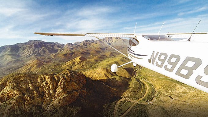
Texas may have wild, wide-open spaces, but that doesn’t mean the public has access to them. Ninety-two percent of the state’s land is, in fact, privately owned, which means that some of our most scenic spots are hidden from view. This can present a challenge to the explorer—unless you happen to have a pilot’s license. After all, no one owns the sky.
If you are among the roughly 39,000 pilots in Texas, you know the state is a breathtakingly beautiful place to fly. With mountains, desert, forests, and coastal areas all within a couple of hours’ flight, the topography beneath you is always changing. There’s also the sci-fi quality of city skylines emerging like stalagmite formations on the horizon—not to mention urban lights at night, which, from the air, look as though the Milky Way exploded on the ground.
But it’s the Texas wild, preserved on some of the state’s private ranches, that offers many of the most surprising aerial views—of herds of antelope, giraffes, and zebras in the Rio Grande Valley, for example, or brilliant blue waterfalls and lagoons in the Hill Country. The most visually stunning and remote spread, however, is arguably Pinto Canyon Ranch, at the base of the Chinati Mountains, in far West Texas. Owned by John “Jeff” Fort III, the 72-year-old retired CEO of Tyco International, the ranch is an arid, rocky stretch of 62,000 acres that includes much of the forbidding Pinto Canyon. Because the canyon’s walls can rise almost four thousand feet, it is most easily approached from the air.
Looking down as you fly over, you’ll see the earth is reddish and rippling, like waves and eddies in a rust-colored sea. The vegetation, low and sparse, is its flotsam and jetsam. The only signs of life are the wild burros that sometimes take shade in the shadows of the rock-and-mortar sculptures erected by the late artist Donald Judd, whose homestead is enclosed by the ranch. As if this weren’t enough, when you drop your altitude to, say, five hundred feet above the canyon floor, you see something else: vestiges of prehistoric life. There are volcanic rocks arranged in almost perfect circles atop mesas—the remnants of primitive dwellings—and recesses in the sides of the cliffs that represent Texas’s first high-rise apartments. You can also see the assorted rectangular cutouts where archaeologists have, with trowels and brushes, dug into and swept away the ruddy earth to find artifacts that date back as far as 11,000 BC, the tail end of the last ice age. Out here, where there is no civilization, lie the clues to the very beginnings of civilization.
Fort, who is an avid hiker, mountain climber, and horseman, did not know about this archaeological treasure trove when he first started buying parcels in Pinto Canyon, back in 1996. But four years later, while scouting the property on horseback, his ranch manager called his attention to a rock. “It was this fifteen-foot-tall petroglyph with all these carvings, and I just said, ‘Wow,’ ” recalls Fort.
His ranch manager guessed it was the scratchings of some Indians, but Fort, suspecting it might be something more, sent a picture of the petroglyph to archaeologists at the Center for Big Bend Studies, at Sul Ross State University, in Alpine. The archaeologists were astonished; what Fort had found was some extraordinarily well-preserved prehistoric art. The discovery quickly led to a partnership between Fort and the center, whereby the ranch owner and the archaeologists are now working together to identify and catalog the canyon’s ancient riches. “It’s like a James Michener novel, where you have a really interesting, long narrative, starting with volcanic upheaval millions of years ago followed by all the trials and tribulations of subsequent generations,” says Samuel Cason, the archaeologist who oversees the project.
Uncovering the ranch’s prehistoric past hasn’t been easy. Access to some sites requires riding in an ATV along winding arroyos and over rising, craggy terrain, then hours of rigorous hiking. There are also poisonous snakes, thorny vegetation, and quicksand pits the size of manholes. But Fort seems undaunted, and he is not alone: Homer Mills, a rancher who manages the nearby 267,000-acre O2 Ranch, has been making similar finds on the spread he oversees, where digs are also under way. Despite not being professional archaeologists, Fort and Mills have studied up and developed an uncanny ability to sniff out where prehistoric people once dwelled. “They’ve discovered much of the archaeology,” says Cason, who has worked with both men. “For all my training and education, I’ve learned to follow their lead.”
In the years since the digs began, the ranchers and archaeologists have hit upon human remains, pottery, arrowheads, cooking implements, and more petroglyphs, as well as rock art that’s reminiscent of cave paintings in France and North Africa. Some of these images are hunting tableaux, while others depict human figures with hands that look like radiant suns. (Fort calls them “Picasso hands,” while Mills, perhaps competitively, is more dismissive. “I think it’s more likely the graffiti of prehistoric juvenile delinquents,” he says.)
As far as Fort is concerned, the search in Pinto Canyon will continue indefinitely. The property is so vast that no one knows how much more there is to uncover; even in the areas that have already been explored, a heavy rain can easily cause dirt to wash away or rock shelves to collapse, revealing more treasures. To help pick out likely areas of prehistoric habitation, archaeologists have used helicopters and drones to create high-resolution maps. “I’m really fortunate to get to work all over the planet, and I can tell you, the archaeology out there is definitely world-class,” says Mark Willis, an Austin-based archaeologist who has done aerial mapping with kites, blimps, and drones in Pinto Canyon. “And with those deeply incised canyons and amazing rock formations, the terrain is just beyond beautiful.”
All the more beautiful when viewed at some altitude. From the air, you can imagine the volcanic eruptions and roiling tectonic plates that created those formations, as well as appreciate the expanses that prehistoric people had to cover to reach safety. You can’t help but wonder how they would have reacted to an airplane’s flying overhead. Would they have been terrified? Probably not, given the more immediate and grim realities they faced on the ground. The thought of such dangers can make you feel far less intrepid, safe in your cockpit with GPS guiding you back over the rim of the canyon, over the mountain peaks and into the clouds.
Getting There: You can fly the perimeter of Pinto Canyon by arranging for a charter flight with marfa gliders (432-386-5505) or simply hiring a charter pilot out of your home airport. If you have a license but are unaccustomed to canyon flying, with its unpredictable downdrafts, you’d do well to contact Roger Amis (rogeramis@att.net), a former pilot for the Border Patrol and a certified instructor who lives in Marfa, and have him ride along on your first attempt. Access into the canyon is restricted, so for landing use the Hot Springs Airport (get advance permission from owner Jennifer Weaver, 432-229-4214) or Marfa Municipal Airport. You can stay overnight at Chinati Hot Springs, owned by Fort and frequented by archaeologists; be nice to the manager, Dianna Burbach, and she might take you on a hike to look for arrowheads (432-229-4165, chinatihotsprings.net).
No. 8 Sand Dunes
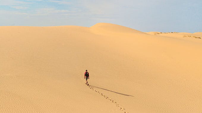
The dunes were aglow in the afternoon sunlight, as though the sand itself were luminescent. A batch of kids charged uphill dragging plastic snow disks behind them, excited for another chance to swoop down the slopes. A roadrunner sat atop a pickup truck, surveying the scene. The 3,840-acre Monahans Sandhills State Park represents a mere portion of a massive field of dunes that extends two hundred miles from the Llano Estacado to New Mexico, and it is a magnet for sand surfers, who come for the Alta-worthy bowls and ridges, some topping seventy feet. The dynamic, shifting sands have a wild, unpredictable quality that you can experience yourself by renting a wakeboard or disk at park headquarters or wandering the 160-acre equestrian area, which has no marked trails. After traipsing through the dunes, I made my way to the park’s miniature forest of shin oak, two-foot-high trees that give both cover and nourishment to the wildlife out here—the sand was littered with the prints of rodents, small birds, lizards, and strange beetles—and whose acorns sustained indigenous tribes about 13,000 years ago. Torn between my thirst and the view, I was mightily relieved when a few fluffy white clouds blew in, a brief spot of shade in this Sahara.
Getting There: From Odessa, travel 38 miles west on Interstate 20, then take the exit for Park Road 41. (Open daily, $3. 432-943-2092.)
No. 9 Palo Duro
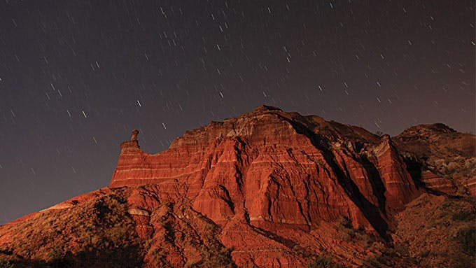
It’s one of those lovely West Texas spring days, when the rain has washed the air clean and the desert is in bloom. My wife and I are hiking along the floor of Palo Duro Canyon amid chinaberry and sotol and juniper, following a small, clear stream with the implausibly grand name of the Prairie Dog Town Fork of the Red River. A red-tailed hawk circles overhead. Above us rise the towering canyon walls. Human beings have lived and taken shelter here since the end of the last ice age, some 13,000 years ago. It is also here that the Comanche, the dominant military power on the South Plains, famously made their last stand in the Red River War.
The canyon looks wild and pristine in the early morning, and in the absence of any other hikers we barely have to imagine the old days at all: they are right in front of us. Here, in the company of wild turkeys and roadrunners, we can practically see the ghosts of the last free Native Americans as they take refuge from the white men they’re warring against—carrying water over the clay soil, stockpiling supplies in caves, building their lodges. Nor is it difficult to conjure that fateful morning in September 1874, when, just a few miles southeast of us, a column of blue-uniformed soldiers under the command of Colonel Ranald S. Mackenzie made its way silently down the canyon’s steep walls and attacked a large Indian camp. The Indians, mostly Comanche and Kiowa, were still asleep; they had been told by a Kiowa medicine man that no bluecoats could possibly penetrate the canyon. Startled into a panic, they tried desperately to protect their horse herd, but it was too late: Mackenzie’s men captured 1,400 animals, and the fleeing Indians were forced to leave behind their clothing and lodges and all of their winter food supplies. Because Mackenzie knew the strategic value of horses, he later ordered about 1,100 of them shot. A pile of their bleaching bones remained for years, as though to document the end of two hundred years of Comanche dominion.
Palo Duro Canyon is a massive spread of complex geology. It is some sixty miles long and averages six miles in width. In its western reaches it is about eight hundred feet deep. After the Indians left for Oklahoma reservations, cattleman Charles Goodnight laid claim to the canyon, this time to raise his vast cattle herds. He co-founded the Panhandle’s first ranch—the JA Ranch—and erected some of the first buildings in the region. Within a few years he had acquired more than a million acres, much of it in the canyon, along with a herd of 100,000 cattle. Soon he was stringing barbed wire in the draws and side canyons where the Comanche had once hunted buffalo.
After our hike, my wife and I head back to the rim and look out over the canyon’s enormous expanse. It occurs to us that you can see it however you want to: as the death of the old Comanche empire or the beginning of the new “civilized” West.
Though most of it is private land—including part of the still prosperous JA Ranch—the 28,000 acres that make up Palo Duro Canyon State Park are the most breathtaking, an abrupt, uneven landscape made all the more dramatic by the strata of rocks that vary crazily in hue: the bright reds of the Quartermaster shale, the yellow and lavender mudstones, the sculpted sandstone that has been stained over millions of years by iron oxides. As the second-largest in the country, the canyon contains all manner of trails for hiking, biking, and horse riding, including the signature Lighthouse Trail, which winds six miles around an astonishing 310-foot hoodoo formation. The day after our first trek, my wife and I watch the moon rise at dawn over the imposing Capitol Peak, then choose to hike the canyon floor again—and not just because we are people of a certain age who aren’t quite as spry as we used to be. Though the higher elevations offer perspective, they are not where the Paleo-Indians or the Comanche lived.
We find a lovely, winding 2.5-mile trail through the hackberry and juniper groves called the Rojo Grande Trail. It follows the same stream as before, which flows small in these parts, and again we are transported back in time. Life took place down here, in the sheltered, almost cozy river bottoms, in the grass meadows and the timber groves. I imagine the Comanche chief Quanah Parker, with his fierce, untamed Quahadi band in the years before the white men killed almost every buffalo on the South Plains. He’s sitting by this clear stream, watching the wind play in the leaves of a cottonwood and the moon rise over the canyon rim, almost certainly unaware that all of this limitless freedom is about to end.
Getting There: From Canyon, travel 12 miles east on Texas Highway 217 until you reach park headquarters. (Open daily, $5. 806-488-2227.) You can camp on the canyon floor, but the best place to stay is in one of the cabins on the rim, built by the Civilian Conservation Corps in the thirties (call 512-389-8900 for campsite and cabin reservations). In Canyon, don’t hesitate to visit the Panhandle-Plains Historical Museum for further insight into the people of the plains (2503 Fourth Avenue, 806-651-2244).
No. 10 Lake Crockett
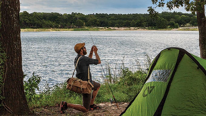
As I trekked along the shady portions of Trail 3, a 6.5-mile route in the Caddo National Grasslands WMA, trying my best to avoid poison ivy, it occurred to me that you don’t necessarily have to head west to find the Texas frontier. The rolling hills and broadleaf forest above the Sulphur River have a rough-hewn beauty all their own. The main portion of the grasslands is the heavily wooded 13,360-acre Bois d’Arc Creek Unit, which has two small lakes, and though trail riders and anglers can make it feel a bit crowded on weekends, during the week the forest feels almost entirely yours. The larger lake, Coffee Mill, is reputed to have some of the best crappie fishing in the state, but after my walkabout, I set up camp near Lake Crockett instead—and I can testify that the fishing is still pretty good. I grabbed my rod and within a few casts had caught my first crappie. Nearby, a couple of tween boys managed to reel in a three-pound largemouth. Later a chuck-will’s-widow sent his whistle into the night, over and over, and a beaver slapped the lake with his tail. The sounds of the Wild East.
Getting There: From Bonham, travel 16 miles east on U.S. 82 to Honey Grove, then 12 miles north on FM 100. Take a left onto FM 409 and go 2 miles to the WMA entrance. (Open daily, free. 940-627-5475.) Camping is $4 a night. You will need a fishing permit, available from Texas Parks and Wildlife.
No. 11 Goat Island
Canoeing across Caddo Lake, my seven-year-old daughter, Ursula, and I were struck by its eerie beauty. Spanish moss hung from the limbs of centuries-old bald cypress like a shroud. We’d spent the night in one of the air-conditioned log cabins at Caddo Lake State Park, even roasting marshmallows before bed, but now we were on a primordial quest to uncover the lake’s mysteries.
The indigenous tribes that loaned this body of water their name—the Caddo—believed an earthquake formed the lake; modern geologists theorize that its origins trace back to a logjam on the Red River. Though at forty square miles it is considered the largest “natural” lake in the state, its water levels are in fact controlled by the Army Corps of Engineers. This hardly mattered to Ursula or me: in the maze of bayous, we felt as if we’d entered an old, unspoiled world.
Our destination was Goat Island, a woodsy landmass tucked away within the Caddo Lake WMA that we reached by paddling Carter’s Chute. The lake is home to a vast range of species (220 birds, 93 fish, 47 mammals, 46 reptiles), and a concert of diverse voices surrounded us: frogs, owls, chuck-will’s-widows. We grounded our canoe amid the cypress and counted stars before hitting our sleeping bags. Mystery asserted itself again the next morning when I missed the turn for the boat ramp where we’d parked the car and ended up in a bayou called Hell’s Half Acre. But after passing a mess of lily pads and water hyacinth, we decided to set up a picnic on the secluded shore, content to bask in Caddo Lake’s secrets for just a while longer.
Getting There: From Marshall, travel 13 miles north on Texas Highway 43, then turn right onto FM 2198. Continue for half a mile to Caddo Lake State Park headquarters for canoe and cabin rentals. (Open daily, $3 entry. 903-679-3351.) The WMA is adjacent to the park and requires a $12 limited-use permit. To reach Carter’s Chute, travel a mile north on Highway 43, take a right onto FM 805 East, then follow CR 3444 to the lake. Goat Island is 4.5 miles away across the water.
No. 12 Neches River
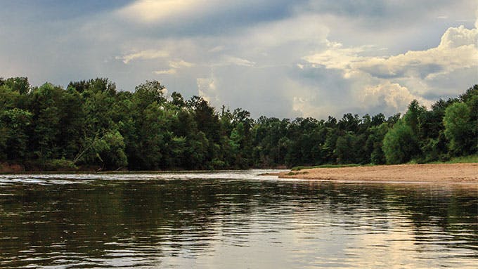
When your guide is a Vietnam veteran who lets it slip that the wooded waterways of East Texas remind him of the missions he led as an elite Army Pathfinder in Southeast Asia, it pays to be ready for anything. If one such waterway is the Neches River, whose banks can be so thick with brush as to appear a solid green mat, it also makes sense to ask what might lurk in the woods.
“Let me tell you, there was a time when you needed to be a warrior to live on this river,” drawled Larry Williams, who along with his dog, Neches (named for the river, yes), was steering our canoe. We were sampling a 10-mile stretch of the 86-mile path the Neches winds through Big Thicket National Preserve, skirting the eastern edge of the 13,300-acre Jack Gore Baygall Unit. Williams was referring to the settlers who migrated here from Appalachia in the nineteenth century, lured by the plentiful timber. I felt the sudden need to keep an eye out for alligators, cottonmouths, and black bears. The Big Thicket is known as “America’s ark” for its biodiversity, and I wasn’t about to be caught off guard.
I soon learned that it’s actually the area’s plant life that gets people most excited—including Williams, who after Vietnam spent ten years studying with a renowned botanist. Some of the last stands of loblolly pine are found here, along with bald cypress, known for its tendency to push “knees” up through the marl. There are also more than twenty types of orchids and four species of carnivorous plants. “If you keep your eyes open,” Williams said, “you’ll always spot something new.” Around us, belted kingfishers hovered over the water, an otter splashed in the distance, and pileated woodpeckers hammered old-growth snags. When we pulled over to camp, three wood ducks—a species Williams hadn’t seen before—sailed down from their roost. And after sundown, the fireflies put on a mind-blowing show that looked more like a fireworks display than the work of tiny insects. “Did you see them?” Williams crowed in the morning. “I’ve never witnessed that before!”
Getting There: Big Thicket National Preserve covers more than 108,000 acres; to get oriented, head first to the visitors center. From Beaumont, travel 30 miles north on U.S. 69/287, past Kountze, and turn off at FM 420; the center will be on your left. (Open 9–5 daily, free. 409-951-6700.) Several local outfitters offer canoe rentals and shuttle services; for information on a guided float on the Neches River with Larry Williams, go to thenechesriverexperience.com.
No. 13 Little Lake Creek Wilderness
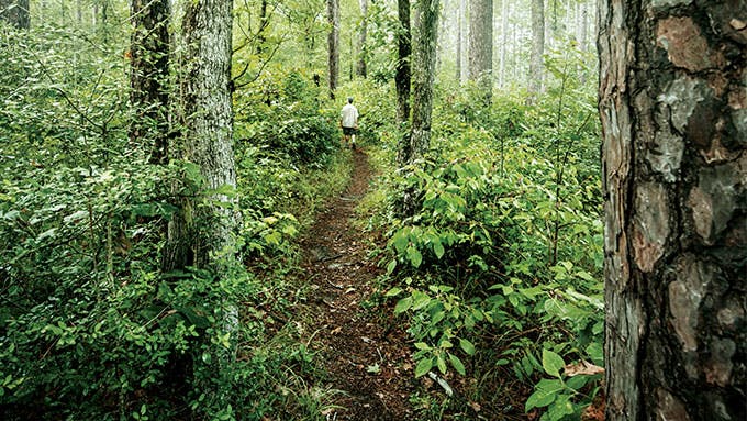
Here is absolutely nobody in the parking lot, nobody on the trail, despite it being a magnificent spring day: blue sky, mild morning sun, and dogwood blossoms floating ethereal beneath the big pines. I’m with my best friend from high school, Kirby—a Houston suburbanite—and his youngest son, Cade, age fifteen. The lady at the ranger’s station for Sam Houston National Forest, near New Waverly, had no recommendations for a trail to take, had never been in the Little Lake Creek Wilderness—3,855 acres without a road, a long and skinny piece of land the shape and size of the world’s most miniature Idaho—and seemed almost curious about why we would want to go, as if, shouldn’t the word wilderness serve as a precaution? Why not just ask her where we could find a good butt-whipping? We tried to get a rise out of her by asking about bears, but she just lifted her eyebrows and said, Officially, no bears.
Was there anyone around who could recommend a trail for us to take?
No. We would be on our own. Into the wild. One of the first federally sanctioned wilds in Texas.
Sweet.
We park, and five or ten paces later, a sign announces we are in the wilderness. Wilderness with a capital W, designated by the U.S. Congress and signed into law by Ronald Reagan in 1984, at the behest of Congressman Charlie Wilson and others. We decide to follow a seven-mile trail known, according to our map, as the South Wilderness Loop. There’s saw palmetto everywhere, reminding me of childhood Easter pageants in East Texas, where these were the fronds laid in church hallways for white-robed actors to walk across, scuffing and rattling.
We’re not seeing much deer sign at all—the forest is too old, wonderfully old, so that the dense canopy screens out much of the sun and prevents the photosynthetic transfer of energy into low-lying forbs, on which the deer could feed. But about half an hour into our walk, we cross a creek between two higher pieces of land—mild swells, not unlike the bump in a bull snake that has swallowed a rodent—and in this low area, this hardwood bottom, there is a game trail speckled with the hoofprints of two or three small deer.
There’s still not much sign, but this is where you might wait and watch, and I think for sure that if I worked in one of Houston’s glittering skyscrapers, evaluating the language of oil and gas leases or executing tax law, I would have to come to this spot frequently in the autumn with my rifle or bow and arrow and sit quietly and wait, and hope, or go stark-raving mad.
Cade asks Kirby how far he thinks we’ve walked. He’s not uncomfortable—not yet—he’s just not had a lot of practice walking so far in a place he’s never been before. We could be going anywhere, we could be going nowhere, and his senses are justifiably tingling. The sign said Wilderness.
Wilderness. Consider the term for a moment. Free from tameness, busting loose. Lighting out for the territory. There was a time, maybe only a generation or two ago, when that was how we thought of ourselves as Texans. And yet, there’s no longer enough truly wild land—land where we will never build roads, never run saws. We’ve chopped and diced, subdivided and ranchette-ed, fenced and built, so that there are tens, maybe hundreds, of thousands of ranches in the state that are larger than this one little designated wilderness.
Walking down the trail, I’m not yet in love. You do not just leave off from going 75 miles per hour on Interstate 45—that rolling howl of commerce for the frenzy of our hungers—and jump out of the Suburban to venture into the wilderness, ready to become in your first three paces a child of God. That’s not a graft that will take. The sun itself, glinting and sliding down off the shiny leaves of the canopy above, must come to rest upon you with a certain accumulated weight.
I don’t shake off this bit of road-husk until we take our first break, sitting on a big fallen log. Thank goodness for fallen logs, unexhumed, unharvested, resting and rotting in just the right place.
Black-water ponds, Spanish moss, crawfish scuttling in clear-water sand creeks, and the filigree of raccoon tracks—I know this country. This is the country I grew up in, played and explored in, the country in which I first learned to love—and need—nature. My childhood home in the Houston suburbs, like those of so many others, chewed into the edges of this land back in the sixties. My God, how did so much time tumble past?
Kirby is looking all around, and up at the tops of trees, with the wonderment of a wallaby that has never touched the forest floor before. A small woodpecker is drumming in the forest below the trail, and it is Kirby who notices the sound; to me, it’s just background noise. I’m still lost in my busy brain, remembering the Forest Service lady who resisted our going into this nasty wilderness. I’m still remembering the traffic, remembering billboards, remembering airline schedules, fretting about money. You can’t go from 0 to 60 in these matters.
Kirby leaves the trail as if in a trance, summoned by the drumming; I follow. We crane our heads but can’t find the bird, though the drumming continues. I’m wandering around, fruitlessly, when Kirby motions me over; he’s found the correct tree by placing his hand on it and feeling the vibrations radiate down the trunk. He places his head against it and smiles, as if receiving some kind of deep medication.
We travel on. A skink patters through the dry leaves—Kirby crouches, tries to catch it, but it’s gone, though we dig through the duff looking for it. I didn’t see it at all, and now I want to, with surprising intensity.
The trail winds, bends, curves. Something ancient feeds into us as our feet transcribe the shape of the land beneath us into our brains. Kirby stops at one of the little clear creeks that lace the woods with shimmering glitter. I’ve already leaped across, intent only on gaining the other side, but Kirby has paused on a tiny sandbar, pressing down on it with his foot, watching a trickle of bubbles come up at the far end of the spit. Bubbles of all sizes and shapes, as if some miniature spring resides there, and he stands looking at it a long time, while all around us, the leaves unfold wider and ever greener.
High above us, a jet is passing, and whether coming or going, Jacksonville or Tokyo, Minneapolis or Johannesburg, I have no idea. If each of us, any of us, had but one more day, how would we spend it? Where would we spend it? What if we had seven more days, or ten, or even twenty? What if we had a thousand?
The day is warming. Kirby is perspiring. At every rest stop, he and Cade drink water; my four airplane sample bottles are drained quickly, long before we reach the halfway point of the loop. I feel bad about this waterlessness—isn’t the humidity enough?—and I wish I could do some kind of Bible trick, some sweet magic, to conjure unending cool water for both of them.
The loop bends out of the wilderness, travels through some nicely managed big pines—Kirby spies another skink, and again, I miss it—and we pass now through a stretch of cutover woods. Some big pines remain, but there are stumps too, and weeds and direct sun and—is this possible?—a big house, a regular old thing with a chimney and a driveway and kitchen windows and a basketball hoop.
Cade and Kirby, tired and thirsty, look long and hard at the house; I gaze into the woods below us. Our map shows we’re at the corner of private and public property. There is a county road just below this square of private land, and the map shows we could walk over to that driveway, follow it out to a farm-to-market road, then to a secondary road, and hitchhike our way back to the other side of the wilderness. No one says anything. I will do whatever they want; they will do whatever I want.
I urge us down the trail. Cade looks back at the house with undisguised longing, and Kirby, ever an adventurer, hesitates. I feel as cruel as if driving a pair of rented mules with a whip, but we continue, into the deeper forest.
Kirby spies another skink, yet again unseen by me. Damn.
We crest a ravine and see a goshawk leap from a branch. We look down on it as the goshawk itself must look down on voles, rabbits, small birds, mice. A swamp world, seething with bounty, just beyond the reach of the long arm of Houston.
We stop to rest again. Something’s wrong with Kirby. His eyes are glassy and he’s sweating like crazy, even when he just sits on a log in the breeze. I sit next to him and show him on the map how we’re just about perfectly halfway, how the place where that hawk got up below us is where we’ve just about rounded the horn: the same distance yet to go, but with the trail still new, untraveled, unseen.
I don’t know it yet, but Kirby is at that point where, medically, reason and good decision-making begin to flicker like the headlamps of an old Ford as it shudders down a washboard backcountry road. All I see is him studying the map and appearing to give it considered thought.
We could shortcut, I tell Kirby and Cade, leave the trail and go through the middle of the wilderness, but it’ll be mucky. It looks short and easy on the map, but once you’re in, it gets big quick. I’ve done this kind of thing a million times, and if we go in, I tell them, we’re going to get lost—deliciously, gloriously, ass-kickingly so. Not until it’s all over—late, late tonight or tomorrow or whenever we get out—will we be glad we did it. “I want y’all to hear me,” I tell them. “If we do this, we will wish we hadn’t.” I love the anguish and confusion of being lost; I’d rather claw and scrabble and stagger and stumble than go back, beaten, over trail I’ve already covered. But most folks do not share my enthusiasm.
Cade is listening; he hears me clearly and does not like what I am saying. But Kirby is not hearing, or is hearing something else. His eyes are so glassy. He looks like he’s listening to something far away, like when he was trying to find the drumming woodpecker.
“Let’s go,” he says.
For a little while, the going is easy. The light is softening; the sun seems heavier. We crest a long rise, wading through cutover young pines that are waist-high. We clutch our map—on it, a few tiny veins, pale blue as an old woman’s, course toward Little Lake Creek, at the center of the wilderness, and the plan we have is to find one of these threads, follow it perpendicular to the main creek, cross the creek, and then find the trail we started out on.
We walk slowly, not like the high school kids we were, but like old gentlemen somehow lost. As if searching for the rest home we have fled.
The forest is still beautiful—the same dogwood blossoms hang like floating snowflakes—but we are lost. We don’t know what the path home will look like, but I cling to the idea that we will know it when we see it. Kirby is still sprouting water, and he keeps stopping after only a few steps.
He looks like he doesn’t know where he is—or even what he’s doing out here, which is, of course, a whole other scale of lost. I don’t know what to do. From time to time I glance at Cade, who looks so young, and I wonder how impossibly ancient his father and I must seem to him. I figure Kirby must just be having a bad day—tired from work, out of shape. I walk as slowly as I can, but still Kirby lags, and whenever I look back, more often than not he is leaning against a tree or clutching his quads. When he sees my look of concern, he smiles, straightens up, and pushes forward, as if embarrassed for my having witnessed his discomfort.
We enter the thick forest; we find a creek, an artery of living water. It’s reddish-black, algae-rimmed but seething with life: minnows and water striders. Kirby looks at it but does not drink. The creek meanders in a beguiling series of S’s, and we creep and wobble through the forest’s rotting leaf-black bottom. We find an old flood-swept whiskey bottle and open it—there’s a quarter inch of amber in the bottom, smelling the same as it ever did—and Kirby, with a flash of mirth, swallows it.
How bad can he be, really?
Still, he’s walking so incredibly slow, and stumbling, just as I said we would. He plows through the great arbors of poison ivy, tumbles down sand embankments and into the creek, the damp banks of which are limned with coyote prints and deer tracks—a veritable highway through the wilderness, six feet below the forest floor. The underground railroad.
The sun drops lower. At one point Kirby leans his full weight against what is surely the world-champion holly tree, its girth thick enough to mill for lumber. We move on, come to a swamp, into which the tannin-bronze vein of the creek disappears; we have no more guidance. We make our best guess, press forward, and, on the other side of the swamp, find it again.
The light has gone to olden tintype, coppery and blood-infused, making it seem as if we’re somehow augering back into time. It feels like we’re making about fifty feet an hour—as if we’re drilling down through stone, rather than gliding through the here and now. I find myself remembering that hawk; how, when we saw it fly away, it dislodged some ripe dogwood blossoms so that they fell, drifting in the heat. If this is to be a last day, it has been a good one.
Sometimes our way in the creek is blocked by a fallen tree, so that we have to climb out of the deep channel, back up to the forest floor, and follow a game trail, stumbling again through thorny greenbrier and poison ivy, with its Adam and Eve fig-like leaves. At one such portage, Kirby can go no farther. He does not fall but kneels, like a football player on the sidelines with his helmet off, and stares into the forest.
Then he lies down.
“My heart hurts,” he says. “My quads are cramping.” He clutches his legs. Then he closes his eyes and either goes to sleep or enters a coma. His breathing is shallow, like that of an injured horse.
Cade—so accustomed to bedeviling, and being bedeviled by, his father, with whom he often gets into hijinks—doesn’t know how serious this is, and neither do I; instead, Cade circles his recumbent father with his camera, snapping away. Facebook fodder, the prone paterfamilias like a giant tree felled.
Kirby naps. The daguerreotype light makes him look like some mortally wounded Civil War soldier. Is he napping or is he dying? Cade and I continue to think he is merely out of shape, just more so than I would ever have guessed a person his age could be.
He has finally stopped sweating so profusely—is not sweating at all—but that may be because we long ago ran out of water. Cade and I sit next to him like hounds and shoo the mosquitoes away and watch him, willing him to get better. Waiting.
After about half an hour—blue twilight now—Kirby rises, unsteadily, and we resume our long creep through the darkened forest. We reach Little Lake Creek in true darkness, splash across it, scramble through brush and up a steep slope, guessing and hoping, until almost miraculously we intersect the trail that the map assured us would be there—the same trail we strode on earlier in the day, with so much power and vigor and confidence.
We hobble an hour back to the car, where Cade has a tiny bit of Dr Pepper left, nothing else. A heated half sip, max.
We drive to town, delirious.
And leaving the grocery store—carrying out armloads of Vitaminwater and bananas—we try to tell various people where we’ve been, but no one has heard of the wilderness, or even the large national forest in which it is located, half an hour up the road.
We get rooms for the night in the next town. One of those exurbs of Houston. The long arm, the ever-extending tentacle. Malls, each one a battlefield of the soul, are hard to even look at, after swimming amid the dogwood blossoms. Hydrated, Kirby is starting to feel better. We sleep again, dreaming swamp dreams.
In the morning, Kirby knocks on my door. He says his doctor had him on some new blood pressure medicine, and he only this morning read the instructions for it. The label warned to avoid getting hot and to avoid exertion; such activities could result in abnormal sweating and heart arrhythmia, followed by death.
It’s more than sobering, and we marvel at our fortune—at how, by all rights, we should have gotten in far more trouble than we did. We marvel at how instead we had so much grace bestowed upon our little passage, our little hike.
What must it have been like, I wonder, when all the land was once this way?
We eat breakfast quietly at some nondescript waffle place, not saying much, just remembering the day before and listening, through the plate glass of the restaurant, to the roar of traffic out on the highway. Then we go outside, into the rising heat, and get in our Suburban, and join the great hurried flow, heading back into the city, farther and farther away from where we have briefly been.
Getting There: Little Lake Creek Wilderness is in the southwestern corner of Sam Houston National Forest, which is off I-45 and U.S. 59 about 50 miles north of Houston. Stop for maps and trail information at the ranger’s station, 3 miles west of New Waverly on FM 1375. Continue west on FM 1375 until you reach FM 149, then turn left and drive until you reach the first parking lot for Little Lake Creek Wilderness. (Open daily, free. 936-344-6205.)
No. 14 Texas Water Safari

The names on our boat say “Lester”and “Danny,” but that isn’t us. We don’t bother to correct all the people who call out in our direction as we wait in the middle of a crowd of canoes and kayaks at the Aquarena Center, in San Marcos. We’re at the start of the Texas Water Safari, an annual race down the San Marcos and Guadalupe rivers, and we have other things to think about. It is already hot—mid-June—and we have one hundred hours to make it to Seadrift, a small town on the Gulf Coast almost 265 miles away.
Also painted on the side of our canoe is “Port Lavaca, Tex.,” which is where Lester and Danny are from. Keeping the lettering on the boat was Doug Johnson’s idea. Doug is the sternman in our two-person outfit, an Austinite in his mid-thirties whose notion of a good time is bow-hunting wild boar or entering hundred-mile mountain bike races. He’s told me that Danny is an old family friend who attempted the Texas Water Safari twice back in the eighties. Both times the man in the front of the boat—Lester, I presume—suffered a serious back injury and quit the race. The pair was training for a third try when, during a night run, a large alligator gar leaped into the boat. Danny called it quits after that, and the boat sat in a barn for thirty years until Doug discovered it.
A bearded guy hollers something into a bullhorn, and we are moving, trying to keep our position as we haul the canoe to the water. There are 108 boats in multiple classes, a frenzied throng of human-powered watercraft. The first third of the race will take us down the clear green depths of the San Marcos River, whose banks are lush with water hyacinth, sedges, and mosquito ferns and shaded by towering bald cypress, pecan, and live oak. It’s also a litany of dams, bridges, and portages—some of which, like Staples Dam, involve hoisting your boat over a cement barrier and down a steep set of steps. Others, like Ottine Dam, require tramping through weeds on sodden cow paths, occasionally working under barbed-wire fences or through somebody’s front yard.
Failing to finish isn’t uncommon. The TWS bills itself as “the world’s toughest canoe race,” a claim that seems to go unchallenged, and nearly 40 percent of entrants drop out. There are longer races out there, but none with quite the same hazards—heat, rapids, grueling portages, dangerous wildlife—or potential trauma: twisted joints, broken bones, rashes, fevers, vomiting, snakebites, gear malfunction, and, of course, obliteration of one’s will. A ground-support crew, whose members are known as team captains, supplies each boat with food and drink at assigned checkpoints, but otherwise there is no outside assistance.
We launch into the water and head downriver, dodging swimming children and Bud Light–toting dads in inner tubes as spectators crowd the banks. Around every bend there are families camped out in the shallows, chairs and sunshades in the water. The idea that we hail from Port Lavaca elicits frequent cheers—why, I am not exactly sure—but by sunset my lower back is on fire, and I’m cursing the restless spirit of Lester, who I’ve become convinced haunts the front seat. In a narrow boat like ours—a seventeen-foot aluminum Beaver boat—the bowman doesn’t exactly have a lot of room to stretch out. Despite the foam padding on the side rails, my knees and calves are already purpled with bruises.
Still, Doug and I blaze through the early checkpoints, receiving fresh water, electrolyte drinks, and mesh bags of provisions—energy bars, apples, boiled eggs, dried fruit, beef jerky—from our team captains, Vaughn Johnson and Mari-Vaughn Johnson, Doug’s father and sister. We reach Palmetto State Park, the third checkpoint, sixty miles in, where Mari-Vaughn expresses concern for our innards. “You guys feeling okay? Lots of boats have been vomiting,” she says. She hands us another round of peanut butter and honey sandwiches; I take a bite and nearly gag. Doug refuses the food, turning to watch the river and the squadrons of dragonflies instead. Eating is a distant concern.
Night falls, and we press on, threading through a narrow section choked with trees. We paddle by the light of a nearly full moon until the canopy overhead forces us to turn on the set of flashlights we’ve mounted on our bow. For a few seconds we get a clear cone of light, and then every flying insect for a square mile funnels into its beam: mayflies, Asian tiger mosquitoes, sphinx moths, and midges, all of them coursing into the light vortex and into my teeth. After an hour or so we have to turn on our headlamps to stomp on the spiders nesting in the boat.
Suddenly, a large, clawed branch rakes the length of the boat, ripping our lighting off its mount. We pull over so that Doug can do some repair work with a Leatherman and a handful of zip ties, while I swat mosquitoes and curse the darkness. Back on the water, we immediately hit an impenetrable morass of downed trees and debris. We make out some boat tracks and footprints to the right and decide to head to shore again. As we haul the boat up the thirty-foot bank, the deep, viscous mud rips the sandals off our feet. We drag the boat through poison oak, thorn bushes, and fire ant mounds, finally sliding into the water on the other side, exhausted.
By the time we pull into Gonzales, it’s five in the morning, and we’re filthy, our clothes smeared with mud. I am so crusty with my own salt that I can peel it off the back of my neck like a scab. We’ve been awake 24 hours straight now. Our goal is to finish in 70 hours, and we’re a couple of hours ahead of pace, so we decide to nap, stretching out on the gravel beach like dead men. The irregular egg-size rocks are terribly uncomfortable, but before I can give them much thought, I’m out cold. Vaughn kicks my foot half an hour later. My muscles are tight like piano wires, and everything aches, but I am refreshed. I look at our boat pulled up on the gravel, a slice of pale metal. One hundred and seventy-eight miles to go.
Catalog of wildlife observed: snakes—6, none venomous; turtles—60; herons, egrets, and cranes—hundreds; children with second-degree sunburns—a baker’s dozen; floating beer cans—36, an alarming number of them full, Keystone Light the favorite.
The second day has the longest and most uneventful sections of the race, from Gonzales to Hochheim to Cheapside to Cuero. The river slows and widens, changing from the active green of the San Marcos to the sluggish brown of the Guadalupe, and the course becomes an unrelenting slog. The tubing enthusiasts and picnickers we saw upriver have become scarce, and the signs of civilization fade, replaced with layered limestone cliffs. We see the occasional fisherman or “South Texas river condo”—a folding chair and rusted-out grill—but little else. Sycamore, cottonwood, and more bald cypress line the banks; there is primrose and phlox everywhere. Clouds of butterflies and cottonwood seeds drift like a fog in the heat. Hours go by without our seeing another boat; our paddling, despite the pain, becomes trancelike into the night. The river looks the same around every bend, as if we aren’t going anywhere.
The third day dawns hot and hazy, and we spend much of our time hugging the riverbank, searching for shade. We’ve been relieving ourselves into empty plastic bottles as we paddle, and sometime after noon, I fill a twelve-ounce container with something that looks like beef broth, a reddish-brown color that is clearly not right. We’ve grown silent, barely trading a word for hours at a time. I feel delirious, and my arm and back muscles are shredded. I begin to think about my wife and two young children with an ardent affection.
Catalog of wildlife observed: alligator gar—23, including the one that jumps in my lap and vomits his dinner (large moths, a few still alive); alligators—12 or more, hard to say; river houses made of shipping containers—8, a couple of them architecturally interesting; gun aficionados on the bank—3, including somebody going full-auto; spiders—legion.
A few miles south of Victoria, about 235 miles into the race, we hit a series of permanent logjams at about midnight. At the first big jam, we haul the boat up the six-foot bank and, using a rope harness, drag it like mules down a grassy fire road for a quarter of a mile. We get the boat back in the water only to discover another jam fifty yards later. Again we pull out, again we drag. Our leg muscles are shattered, and we hunch over, panting and cursing. We forge through the dense woods, following faint paths through the undergrowth, a confusion of headlamps and savage mosquitoes.
In the darkness we hear a team just behind us, a man and a woman dragging their canoe. I train my headlight on the side of their boat: Blood, Sweat & Beers. Doug and I exchange a look. The canoe is in our same boat class. We rush to the water, desperate to maintain our position, and hastily put in, finding a watery bypass we can take—only to discover this route also blocked. The banks are fifteen-foot mud cliffs, straight up. Behind us, we see Blood, Sweat & Beers thrashing through the woods, lights searching for the same bypass. In a kind of hysterical state, Doug and I decide to scale the cliffs. We find a few floating logs lying against the bank, next to a nest of inverted tree roots, and we devise a plan wherein I’ll flop out of the boat onto a log, then climb the root system carrying the bow line. I’ll haul the boat up the bank as Doug lifts from below. It is complete lunacy.
I turn on my headlamp and find half a dozen hairy spiders perched on the log, each one the size of my five-year-old son’s hand. There’s nothing to be done, so I shut off the light and flop, catching the log in my midsection, then scramble spastically up the roots and to the top of the cliff. I find my footing and haul, Doug pushing from below, neck-deep in the water. Somehow, it works.
I squat in the weeds, exhausted and furious. Doug hoists himself up the cliff like a corpse coming out of the grave. He stands, takes one step, grinning, his floppy hat set back on his head—and then, suddenly, his foot slips, and he falls backward into darkness. No splash, just a sickening thud. I hear him cry out, and I am more annoyed than worried. “You okay?” I say halfheartedly. Miraculously, he has landed on a log in a sitting position, just inches away from the nest of tree roots, which would have skewered him like an action-film villain.
We put on our rope harnesses and haul the damn boat through the woods again, running and falling until we reach the other side of the jam. Our feet and ankles are slashed and bloody, and my whole body itches from the silty, fetid water. I can feel the beginnings of a rash that will make it hard to sit for a week. Worse, I discover that during the logjam melee I neatly snapped the shaft of my paddle. Now I have to use our spare, a hunk of plastic with a blade surface twice the size and three times the weight.
“I will never do this f—ing race again!” I shout at Doug. He stares, hollow-eyed, and spits a stream of tobacco out the side of his mouth.
“Are you mad at me?” he asks.
A line from Blood Meridian floods my consciousness. “How these things end. In confusion and curses and blood.” There are competitors who attempt this race multiple times, some as many as twenty. Why? Why would they subject themselves to this?
The last twenty miles of the night are a hallucinatory horror. We’ve slept two hours over the past three days, and my brain is determined to have its dream time, even if I am awake. Every tree stirring in the breeze is a looming face, a caricature, like a child’s toy or puppet. The naked rocks are large billboards advertising circus shows and carnivals. A pale shape appears in the river, and as we near it, our light illuminates a naked old woman standing in the water, clutching something to her chest. Later, as barred owls coo to each other from the banks, I stare into the water and see a boy—no more than ten years old, shirtless, his skin milky white in the moonlight—standing on the bottom of the river, aiming a crossbow directly at me.
I look away. I think about Lester, the vengeful spirit in our boat. I think about my son, my three-year-old daughter, my wife. An insect storm swarms into our light, and we see the electronic-blue gaze of alligators gliding along the banks. I try to fix my eyes ahead and paddle. But I am desperate for the apparitions to speak.
“Doug, is there a house over there, with a whole family out on the deck, waving to us?”
Doug pops his can of Copenhagen and fingers out a dip. “It’s four in the f—ing morning, dude. No family, no deck, no house. Just paddle.”
We reach the coast at daybreak. The mosquitoes are savaging us through our clothes, and I have bites inside my ear and on my eyelids. The wind is blowing hard from the south, meaning we’ll have to go the last five miles upwind on the open bay, fighting whitecaps the whole way to Seadrift. We stop at a low marshy area to put on our spray skirt and mandatory life vests. A small alligator about three feet long sits on the bank, and Doug nudges him out of the way with his paddle so we can stretch and urinate. I see gator tracks and nest areas everywhere. I do not care.
Daylight makes things comprehensible again, but paddling into the wind is futile. We decide to walk the boat through the shallows, dragging our feet through the mud to scare off stingrays. Then I put the rope harness on and tow the boat while swimming.
It is slow work. Before long, we see a two-man aluminum canoe coasting toward us, headed the wrong way, and the sternman calls out to me. “Do you know where Seadrift is?”
Everyone knows where Seadrift is at this stage, so I am wary. I gesture around the point, tell him it is a couple of miles east. He shakes his head, a rueful grin on his face. A fierce rush of anger overwhelms me. Here I am, swimming in heavy chop with a rope around my chest, dragging a canoe after seventy hours of paddling, and this guy is messing with me. He has come to goad those still struggling through the end of the race.
“What are you trying to say?” I yell at him. “Just say it! Tell me what the f— you want to say to me!”
Doug, about twenty yards behind, is standing in chest-deep water, looking like a stranded scarecrow, and the men paddle over to confer with him. I tread water, the whitecaps breaking in my face. In the washed-out light, the low islands of seagrass and churning brown bay are a watery apocalyptic vision.
I hear the sternman say, “The town is gone, man, it ain’t there!” The poor guy, it appears, is simply disoriented. The two are going the wrong way. Doug eventually convinces them of their mistake, and I turn to keep swimming. Last time we see them, they have beached their canoe and are standing in the mud watching us, hats in hand, sentinels on a wasted plain. They’ll have to head upwind again, all that distance adding hours to their time. The mere thought of this, how it will extend the suffering for these men, makes my heart ache.
We finally make the turn eastward, Seadrift now a faint mark on the coastline. The sky is clear and blue, and the air and water seem charged and luminescent. Exhilaration takes over. I yell to Doug over the roar of the wind, suggesting we just gut it out, paddle hard into the heavy gusts. He nods, and we get back in the canoe.
I paddle these last miles like an automaton, empty of thought, perhaps closer to some kind of Zen state than I’ve ever been. At 43, I’ve presumed to have an understanding of the breadth and depth of my person—physically, psychologically, spiritually—or at least to know what I am capable of. But I had no idea. I keep stabbing the paddle at the water and pulling. I’ve reached some kind of primordial frame of mind where it is all just instinct, all here and now. I feel like I could go on like this forever. Lester, that restless spirit, is gone.
It is late morning when we finish, in just over 74 hours. We place third in our class and forty-second overall. We carry our canoe up to a lively crowd of people, a lot of handshaking and pictures. Then I see my wife and children, who have made a surprise trip from our home in Dallas to meet me. I kneel down to embrace my son and burst into tears.
At the lunchtime banquet, I eat three plates of fried seafood and the best beans I’ve ever had in my life. I sit in a lawn chair and hold my kids. I don’t say much. I keep getting emotional when I try to talk, and I realize it is because I am afraid. I have scraped bottom, dug deeper, and found more room. But now I don’t know how much more space there is. And I know that I will have to find out.
At the finish, I meet the original Danny, who is there to congratulate us. I ask him about Lester, his ill-fated teammate. “Oh, that was someone else,” Danny says. “Lester was never even in that boat.”
Getting There: The Texas Water Safari is held every year in June. The best viewing areas for spectators are the Aquarena Center, in San Marcos, where competitors launch into the water; the first major portage, at Rio Vista Dam, where the gutsiest racers run the dangerous spillways; and the Cottonseed Rapids, on the San Marcos River, whose rocky stretches end up wrecking many boats. For course maps, schedule, and entry information, visit texaswatersafari.org.
No. 15 Ice Cream Hill
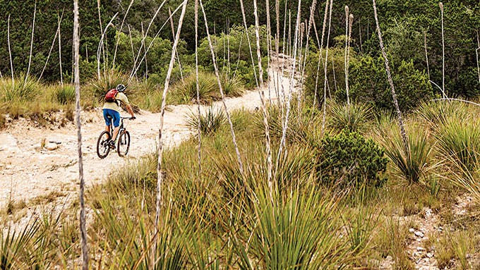
“Maybe you want something a little less steep.” The ranger spoke in a neutral tone, but her words sounded like a challenge. As I contemplated the more than forty miles of multiple-use trails that crisscross the limestone-pocked Hill Country SNA, I was not about to admit defeat—at least not before trying my luck on a few of the more measly slopes. (I say “measly,” but that’s relative when the rise from canyon to cliff top can span two thousand feet.) These rocky canyon lands are great for hiking and horseback riding—if you don’t have a pony, local outfitters can arrange one—but I had come to mountain bike, and I quickly set off on the gnarly terrain. Though there are deer and bobcat in these parts (it’s one of the few areas where I’ve encountered a live armadillo), that day I had the trail to myself, and soon I was huffing and puffing up the backside of Ice Cream Hill. I decided whoever had come up with that name must have been hallucinating, but then, after an unplanned detour into a cedar thicket, I rolled onto a nice bobbing stretch of single track along Bandera Creek. Not too steep, it was very sweet.
Getting There: From Bandera, travel south on Texas Highway 173, then take a right onto Ranch Road 1077. Travel 10 miles to the end of the blacktop, then continue on the caliche road, following signs to Hill Country SNA headquarters. (Open 8–5 daily, $6 day use. 830-796-4413.)
No. 16 Norias Division
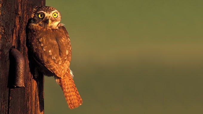
It was oh-dark-thirty, so I could not yet make out the improbable oak trees dotting the South Texas brush. Still, as I piled into the van with a group of birding enthusiasts from as far away as Ontario and Boston, it did not escape my notice that our guide, a biologist named Tom Langschied, had already pulled on tall, snake-proof boots. Though Captain Richard King’s legacy rests on his having tamed an 825,000-acre spread, the legendary King Ranch remains in many ways untouched, sustaining a vast host of wildlife that includes more than 350 bird species. My fellow travelers and I had come, snakes notwithstanding, to catch the tail end of the spring migration; as we bounced across the Norias Division, we scoured the coastal prairie like pilgrims searching for the Holy Grail.
We did not have to look hard. Langschied, who has led the ranch’s ecotourism program since the late nineties, knew just where to point us, and soon we’d spied everything from three or four ferruginous pygmy owls to several tropical parula to small flocks of Botteri’s sparrows. Each new species sparked a small ovation. One man from Florida managed to add three or four to his life list in an hour; a woman celebrated reaching her target of six hundred birds, approximately two thirds of the entire species tally for North America. My own total was forty species for the day. We finished the trip elated, as if we’d shared in the riches of King himself.
Getting There: All King Ranch birding and nature tours begin at the visitors center. From downtown Kingsville, travel west on Texas Highway 141, then take a left onto King Ranch Road. For pricing, dates, and registration, visit king-ranch.com or contact the center (361-592-8055, visit@king-ranch.com).
No. 17 Resaca Loop Trail
In the three and a half years since Seth Patterson began managing the Sabal Palm Sanctuary, he has received regular phone calls from would-be visitors wondering where Mexico begins. That’s because, to reach the sanctuary, which is home to one of the last stands of old-growth palm forest in the United States, travelers must pass through a gap in the border wall. “It’s not a popular place for trafficking,” says Patterson. “But people do call, wanting to know if they need their passport.”
You don’t, though after paying the entrance fee at the Rabb Plantation House—a two-story mansion built in 1892—you will find yourself transported into an ancient, otherworldly ecosystem where feathery palm fronds appear to tickle the light. Follow the trails around the resacas—former channels of the Rio Grande—and through the dark sabal palm jungle, and you’ll soon discover a host of strange and colorful birds; if you go early in the day, when reptiles come out to warm in the sun, you may also see one of Texas’s rarest snakes, the Central American speckled racer. When I visited, on a cool, foggy morning, the speckled racer never showed, but there were bright-green jays at the feeders, long-billed thrashers in the underbrush, and the Lower Rio Grande Valley’s signature chacha-lacas squawking like feral chickens in the branches.
Back at the plantation house, I found a scope that Patterson and his colleagues had set up for visitors to spy on a great horned owl that was nesting in the palms next to the building. As I peered at her, the bird stared in my direction, as if miffed by my intrusion. This made some sense: a century ago, all but a relative handful of these palms were lost, destroyed by human activity. Humbled by her yellow-eyed glare, I felt grateful for this little protected paradise that remains.
Getting There: From U.S. 77 in Brownsville, exit east onto International Boulevard. After almost a mile, turn right onto Southmost Road (FM 1419) and continue for 6 miles, then turn right on Sabal Palm Road, passing through the border wall. (Open 7–5 daily, Adults $5, children $3. 956-541-8034.)


