
The “Drive” Drive
By Joe Nick Patoski
ROUTE: West of Ozona to Sanderson
DISTANCE: 85 miles
NUMBER OF COUNTIES: 3
WHAT TO READ: James H. Evans’s Crazy From the Heat
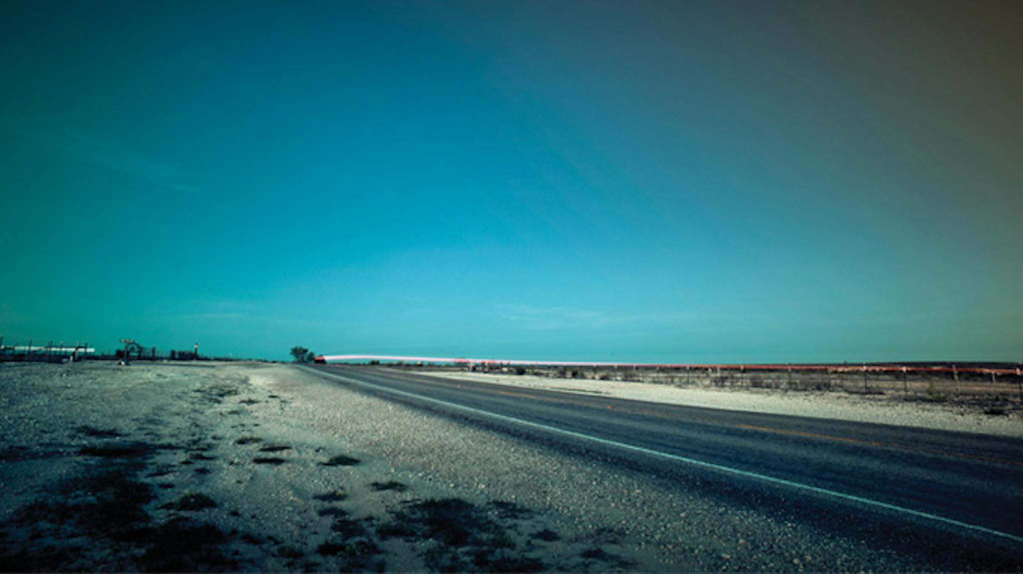
A drive whose sole purpose is to experience the simple pleasure of being behind the wheel has a few requirements. The route must lead west, because that’s the story of Texas and America. The road must be off the beaten path and as free from traffic as possible. And the driver must have an open mind and an eye for discovery.
That’s why my favorite drive in Texas begins 23 miles west of Ozona, dipping south from Interstate 10, where the speed limit is 80 miles an hour but the landscape is so vast I feel like I’m hardly moving. Buttes and outcroppings covered with oak, mesquite, and prickly pear are interrupted by green river valleys. This is the canyon country of the Trans-Pecos, where the Hill Country and the Edwards Plateau transition into the Chihuahuan Desert and the basin-and-range topography that defines the West begins. It is one of the emptiest—and most scenic—parts of the state, and I am completely at home.
From I-10, I follow Texas Highway 290 west toward Sheffield, and the hills morph into mesas and small mountains. The brush looks harsher and thornier, and the exposed soil is rendered into hardpan or rubble as creosote, catclaw, and other desert plants appear. This stretch of highway is part of the old route that ran from Austin to El Paso before the interstate, but it is still broad-shouldered and sturdy. It’s lonely enough for drivers passing in the other direction to wave or offer a raised hidy finger, acknowledging their fellow traveler.
Nine miles later, the cactus-studded overlook above Fort Lancaster State Historic Site marks the literal edge of the old frontier. This was one of the roughest drops for stagecoaches along the Old Government Road, the trail that ran from San Antonio to El Paso. Beyond the fort, which once boasted 25 permanent buildings but now consists only of ruins for visitors to explore, a rusty metal truss bridge crosses the swift-running Pecos River. That leads to the outskirts of Sheffield, where you pick up Texas Highway 349 and head south for eleven miles. Turn right onto Ranch Road 2400, a tighter two-lane highway with a smaller shoulder, a sprawling desert landscape, and far to the west, mountains rising on the horizon. No buildings, no billboards, no trace of humanity interrupt the view.
Where could this be? Mexico? The Sand Hills? Greece? For 39 more lonely miles, the road runs through broad canyons and magnificent desert vistas to the junction at U.S. 285. From there it’s 16 miles into Sanderson, the Cactus Capital of Texas and a charmingly ancient railroad town. The road twists and curves as the first signs of civilization appear: Sanderson Wool Commission, small houses, mechanic shops, and finally U.S. 90.
Turn left and it’s less than an hour to Judge Roy Bean’s Jersey Lilly saloon, in Langtry. Go right and it’s less than an hour to Marathon. Big Bend National Park is a little more than an hour beyond that. Alpine, Marfa, Van Horn, and the great American West beckon. Where you go doesn’t really matter, because you’re already Somewhere Else. And that’s what a “drive” drive is all about.
The Road to Nowhere Drive
To be fair, Ranch Road 2810 isn’t exactly a road to nowhere—it leads
to the oasis of Chinati Hot Springs. But this spot outside Marfa did provide the perfect setting for this month’s gorgeously remote-looking cover. It’s unlikely that you’ll see another soul out here (except maybe the Border Patrol), and be forewarned: the final 22 miles bump along over a gravel road, so a high-clearance vehicle
is recommended.
START: Marfa
END: Chinati Hot Springs
DIRECTIONS: West on
RR 2810 (look for the sign for the springs)
DISTANCE: 55 miles

The Birding Drive
By Patricia Sharpe
ROUTE: Mission to South Padre Island
DISTANCE: 89 miles
NUMBER OF COUNTIES: 2
WHAT TO READ: David Allen Sibley’s The Sibley Guide to Birds
Hugging the U.S.-Mexico border in far South Texas, the sultry stretch of land known as the Lower Rio Grande Valley is the Casablanca of the bird world. Sooner or later all of the usual—and some very unusual—suspects end up here. Want to see a green jay, which looks as though it has been dunked in a bucket of chartreuse paint? No problem. What about a black-and-orange Altamira oriole, which wears a Halloween costume year-round? Easy. Species from Mexico and Central America find the Valley’s subtropical climate very much to their liking, and U.S. and Canadian birds take time out here for R&R during their marathon migrations.
Happily, seeing some of the five hundred species that live or visit here is a breeze because many top sites lie just off U.S. 83. And though I saw my fair share of fast-food joints and trailer parks, what
I remember most about the scenery are the palm trees and bougainvillea that dot the route.
Begin your trek near Mission at the sprawling Bentsen–Rio Grande Valley State Park. This oasis is part of the World Birding Center, a fantastic group of nine government-sponsored sites spread across the area. Right off the bat, I saw a great kiskadee, a flycatcher with a black-and-white mask and bright-yellow vest. As it turns out, the mammal-watching isn’t too shabby either. I joined forces with a couple from Wisconsin, and the three of us waited patiently for a bobcat, javelina, or coyote to cross the trail as daylight faded.
Just a mile away is the National Butterfly Center, where more than two hundred species of butterflies have been sighted. Kids love the green ravine called the Hackberry Trail that forms a sort of leafy secret tunnel. At the end of it is a clearing where multiple bird feeders and slices of fresh orange guarantee you’ll see something fun, like a flock of red-winged blackbirds or maybe some zebra butterflies. For a change of pace, from there I headed eleven miles east to a WBC site in McAllen called Quinta Mazatlan, a lovely Mexican colonial–style house encircled with walking paths and well-kept lawns. There I was startled by a whole flock of chachalacas, big, goofy brown birds that sound like a cross between a turkey and a donkey.
At Estero Llano Grande State Park, in Weslaco, another WBC site, a ranger informed me that it is the best place in the Valley to see paur aques (“par-ah-keys”). You’ll need keen eyes, though, because these astonishingly camouflaged relatives of nighthawks look exactly like a pile of dead leaves. After a stroll, relax on one of the park’s decks overlooking a tranquil pond and let the world fly or paddle by. During the Big Sit birding event last year, an astounding 99 species were spotted in 24 hours.
Rested up, get in your car and continue east on U.S. 83 before turning onto Texas Highway 100. The road rolls toward warm sea breezes and the South Padre Island Birding and Nature Center, a WBC site where you can see dapper gray-and-white laughing gulls and ponderous brown pelicans sail over the water. Finish your Valley excursion by going north via Park Road 100 as the Gulf of Mexico spreads out before you. When you reach the numbered beach roads on the right, park, take off your shoes, and go scrunch your toes in the sand. Give the horizon your best thousand-mile stare and enjoy the salt air and solitude at the very tip of Texas.
The
Wildflower
Drive
Every Texan has his or her favorite stretch of road for seeing wildflowers each spring. Might we suggest one of our own, where bluebonnets, Indian paintbrush, and countless other varieties rule the Hill Country for a short but glorious time each year?
START: Brady
END: Llano
DIRECTIONS: East on Texas Highway 71
DISTANCE: 54 miles

The Music Drive
By Joe Nick Patoski
ROUTE: Turkey to Lubbock
(the long way)
DISTANCE: 366 miles
NUMBER OF COUNTIES: 13
WHAT TO LISTEN TO: Buddy Holly’s That’ll Be the Day and
Waylon Jennings’s Ol’ Waylon
West Texas is the Texas of wide-open spaces, but it is also the Texas of music giants, starting in the Rolling Plains in the heart of red-dirt ranching country, not far from the 6666 and the Matador. The landscape is sparsely populated and visually powerful, and the sky is so big that only the most creative imagination can fill up the canvas. That was the case with James Robert Wills, who came from a farming family near Turkey and went on to become the King of Western Swing. That point is driven home at the Bob Wills Museum at the old Turkey grade school, where his life is recounted in phases through storyboards, photographs, and album covers.
Heading north from Turkey, drive 88 miles on Texas Highway 70 to Pampa, crossing undulating grasslands and passing over eastern extensions of Palo Duro Canyon. In downtown Pampa the old Harris Drug Store, where Woody Guthrie worked as a teenager and first learned guitar, is now the Woody Guthrie Folk Music Center. Guthrie’s story is told through photographs, letters, and news clips, and his legacy as the greatest folk singer in American history is celebrated with live jams twice a month. In July the center will celebrate Woody’s one hundredth birthday. About a mile west is the 150-foot-long “This Land Is Your Land” music-note fence.
From Pampa, it’s 55 miles to Amarillo on U.S. 60, then 18 miles south on Interstate 27 to Canyon. Though the Panhandle-Plains Historical Museum does not yet have a permanent exhibit on West Texas music (hint, hint), if you call in advance, you can arrange to see Bob Wills’s fiddle.
Now you have entered the pancake-flat Llano Estacado, where windmills and grain elevators dominate the horizon. It’s a straight shot for 88 miles on U.S. 60 to Clovis, New Mexico, home of Norman Petty Recording Studios. Kenneth Broad and his wife, Shirley, lead tours of the studio where Buddy Holly and the Crickets, Buddy Knox and the Rhythm Orchids, and a slew of other bands recorded hits in the late fifties and early sixties. If you get the fever, pick up some taquitos and burgers from the Foxy Drive-In, like Buddy and the boys used to do, and stroll through the new Norman and Vi Petty Rock and Roll Museum, with floor-to-ceiling exhibits filled with artifacts from the Pettys and the Texas musicians they worked with.
Pick up U.S. 84 heading southeast, and you’ll pass a string of farming communities and a billboard that identifies Littlefield as the home of Waylon Jennings. Follow Waylon Jennings Boulevard (FM 54) into town to Hall Avenue, where you’ll find the most unusual music museum in West Texas, inside Waymore’s Liquor Store. Run by members of Waylon’s family, it features his first guitar, his handwritten backstage pass for his parents, and assorted memorabilia. But the best part of the collection is James Jennings, who will gladly tell you vivid stories that bring his older sibling back to life.
Continue on U.S. 84 for 36 more miles until you roll into Lubbock, the home of Buddy Holly and the Crickets (and the terrific Buddy Holly Center). Head east to 108 E. Broadway to see a statue of C. B. Stubblefield, which marks the spot of his original barbecue joint, where Joe Ely and Jimmie Dale Gilmore polished their musical chops. Then turn right on Martin Luther King Jr. Boulevard and left on E. Thirty-first, where you’ll find the City of Lubbock Cemetery. Holly’s gravesite is plainly marked, and tradition calls for you to leave a guitar pick on his headstone. Don’t let tradition down.
The Canyon Drive
We’re not jealous that a certain canyon two states to the west gets all the fanfare, but the uninitiated should see the majesty of Caprock Canyons and Palo Duro Canyon.
START: North of Quitaque
END: East of Canyon
DIRECTIONS: Start at Caprock Canyons, just north of Quitaque on FM 1065, and drive south to Texas Highway 86. Follow 86 west through Silverton to Texas Highway 207, then head north. At FM 285, proceed west, then head north on Interstate 27. Finally, turn onto Texas Highway 217, near Canyon, and go east to Palo Duro Canyon State Park.
DISTANCE: 105 miles

The Lighthouse Drive
by Katy Vine
ROUTE: Port Arthur to Port Aransas
DISTANCE: 308 miles
NUMBER OF COUNTIES: 11
WHAT TO BRING: A pair of binoculars
I started as far east as you can go on the Gulf Coast and still be in Texas. And since the Sabine Pass Lighthouse, which is technically across the state line in Louisiana, is on a private road, I decided to drive along the border just south of the Sabine Pass Battleground State Historic Site, on First Avenue, until the structure came into view. Even from a distance, it was impressive. While only about as big as my thumb when my arm was outstretched, I could clearly make out the octagonal lighthouse, built in 1857. It was a whopper—80 feet of brick going straight into the air as if ready to lift off from its eight giant buttresses. To the east, only a few buildings dotted the landscape. To the west, there was nothing but marshland as far as the eye could see.
After lunch, I headed toward the McFaddin National Wildlife Refuge. I had wanted to snake next to the Gulf by way of Texas Highway 87, but hurricanes had damaged some parts of the road between Sabine Pass and High Island, so I wound my way west out of Port Arthur along Texas Highway 73. The landscape quickly changed back to marshland, with tall grass on either side of the road. I passed Boondocks Road and Big Hill Road, along with other references that reminded me I had left the city far behind.
When I finally returned to Highway 87 and reached Bolivar Peninsula, I began driving alongside the water. I passed only scrub for a long while and then, near the west side of the peninsula, groups of houses in teal, coral, yellow, and white, all on stilts. It was here that I nearly drove off the highway when I spotted the 1852 Bolivar Point Light Station on my right. I realize it’s 15 feet shorter than Sabine Pass, but the black 65-footer is so close to the road it’s hard not to rubberneck. My apologies to anyone inconvenienced by my spastic weaving.
Continuing along the coast for 154 miles, I headed toward Port Lavaca on Texas Highway 35, and after passing a good deal of lush farmland, I started seeing little bays and long bridges. The Half Moon Reef Lighthouse was directly next to the highway, built on pier and beam. Its wood exterior was painted white, and unlike any other lighthouses on my tour, I could simply walk inside. It isn’t as tall as the others I saw; in fact, it’s barely three stories high. Built in 1858 in Matagorda Bay, the hexagonal structure weathered many hurricanes until a storm in 1942 did it in for good. A private resident bought it, moved it inland, and donated it to the Calhoun County Historical Commission. I walked around inside the structure—I even had to turn the lights on myself—and wandered in a circle looking at photographs of the beacon at its original site.
But the prize of my trip was still seventy miles away, in Port Aransas: the Lydia Ann Lighthouse. Located on an island and privately owned, it still has a keeper and a functioning light. From Aransas Pass, I headed down Texas Highway 361 and spotted the lighthouse from a distance, the only structure on the entire horizon. Originally built in 1855, it has suffered some damage in the intervening years, but it is currently in great shape, a 55-foot-tall octagonal brick tower. The best view, I was told, is at Virginia’s on the Bay seafood restaurant, and as I sat at my table, I marveled at the scene. But next time I’ll know to time my arrival at dusk, when the beacon is fully illuminated.
The
Off-Road
Drive
If you’ve ever wanted to keep going after the road ends, the beach at Padre Island National Seashore is the perfect getaway. The views of the Gulf are stunning, but take note: a four-wheel-drive vehicle is essential, and it’s wise to call ahead to find out about current conditions (361-949-8175).
START: Park headquarters, on Park Road 22
END: At the southern tip of the island
DIRECTIONS: No roads, no traffic, no problem. Just keep heading south on the sand.
DISTANCE: 60 miles (one way)

The Hill Country Drive
By Courtney Bond
ROUTE: Bandera to Concan (and back)
DISTANCE: 125 miles
NUMBER OF COUNTIES: 3
WHAT TO LISTEN TO: 104.3 FM,
the Ranch
A great drive may be about slowing down and clearing your head, but who can resist roads lined with signs warning of “Earth Slides” and “Steep Grades, Sharp Curves”? Born of massive geological upheaval, this corner of the Hill Country is stunning, its lush valleys and stark canyon ridges painted in weathered hues of slate and ocher and moss. It’s a landscape that will make you slam on the brakes, camera at the ready, and declare, “Now, this is the Hill Country.”
The ideal jumping-off point for this beautiful loop is Bandera, a bohemian community of longtime ranchers and weekend cowpokes that some chamber of commerce official had the good sense to proclaim the Cowboy Capital of the World. Fuel up at the Grotto, where handsome young fellas are peddling Cornish game hen in a land where sightings of the Ben E. Keith truck are all too frequent.
Head northwest on pastoral Texas Highway 16 to Medina, the—wait for it—Apple Capital of Texas. There’s no better ambassador than Love Creek Orchards, where you can pick up your own apple tree and a cone of apple ice cream. Then go west on Ranch Road 337, with its dramatic dales and rolling hills, the latter crowned with the occasional manse, its walls made of glass the better to survey the tableau. Next stop is Vanderpool, so named for its first postmaster, who must have been mighty special to have his name supplant the town’s previous appellation: Bugscuffle. Together with nearby Lost Maples State Natural Area, the site is a veritable siren song for birders, hunters, and all manner of wildlife—bats, javelinas, wild turkeys, and the ever-present Harlius motorcyclus.
Roll on to Leakey, bearer of yet another lofty moniker, the Swiss Alps of Texas. The majestic 2,400-foot rock faces seem beyond compare to me, but you can debate that over a cold one at the Bent Rim Grill, an icehouse that caters to—you guessed it—bikers but welcomes the four-wheeled traveler as well.
Take a bit more time for a vueltecita down to Concan. In his elegy for the Brazos, John Graves writes of the way in which “pieces of rivers can have meaning,” and this little stretch of the Rio Frio is my piece, conjuring memories of my grandparents, Styrofoam koozies in hand, sitting in teetering aluminum lawn chairs on the limestone banks and watching me relieve the crystal-clear water of a large number of its mossy rocks. Detour to the squiggly roads that jut off to the east of U.S. 83 (1120, 2748, 350, 348), whose elegant pas de deux with the cypress-lined Frio allow for a few thrilling opportunities to drive through the water at the river crossings.
Head north again, to Ranch Road 1050, a curvy road you’re likely to have all to yourself as you cruise over to Utopia, whose motto is “A Paradise: Let’s Keep It Nice” (at three square miles, that seems doable). If you’ve worked up an appetite crossing the river wild, options abound. Cherry pie at Lost Maples Cafe? Roasted carrot soup with ginger from a Cordon Bleu–trained chef at the nearby Laurel Tree? Or how about going east on FM 470 to Tarpley, where you’ll find Mac and Ernie’s, a little cottage legendary in these parts for dishes like quail basted in ancho chile honey. There’s the Williams Creek Depot too, whose corrugated tin walls house an amiable woman behind a sliding-glass window, looking as if she’s been waiting all day for you to order a mushroom-Swiss burger.
“The hard thing is to get slowed down,” writes Graves at the outset of his Brazos journey. The truth is, the country here practically demands it, its landscape shaped over eons, traversed by golden-cheeked warblers and nine-banded armadillos, and populated by residents for whom the hi sign is a bare-minimum courtesy. Resist the urge to stomp on the pedal as you head home. Whatever you have to get back to will keep just a little longer.
The
BBQ Market
Drive
No drive across Texas would be complete without smoked meats. Thankfully, Central Texas provides a venerable group of joints that serve some of the best food on earth: City Market (Luling), Gonzales Food Market (Gonzales), City Market (Schulenburg), Prause Meat Market (La Grange), and City Meat Market (Giddings).
START: Luling
END: Giddings
DIRECTIONS: From Luling, head southeast on U.S. 183 to Gonzales. Then take Texas Highway 304 north to Texas Highway 97. Follow 97 northeast to Interstate 10, then drive east to Schulenburg. Take U.S. 77 north through La Grange to Giddings.
DISTANCE: 96 miles

The Backwoods Drive
By Michael Hall
ROUTE: Uncertain to Jasper
DISTANCE: 140 miles
NUMBER OF COUNTIES: 6
WHAT TO LISTEN TO: Jim Reeves’s
“Welcome to My World”
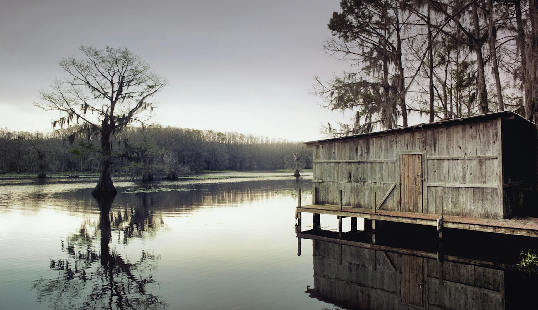
If you want to see, smell, and taste the Deep South, look no further than East Texas. Start your drive in Uncertain, but before you even get behind the wheel, take a short walk onto a narrow pier near Shady Glade Cafe over Caddo Lake, the only natural lake in the state. Out of the still and quiet waters, the tall cypress trees grow, their limbs weighted with long strings of gray moss. Ducks glide in twos and threes past old boathouses faded in the morning sun. Below the murky water swim bass, catfish, and, without a doubt, alligators.
Climb behind the wheel and leave Uncertain behind, driving past B&Bs and signs for steamboat rides and boat tours. After making a right onto FM 2198 and another onto 2412, you’ll hit the Big Pines Lodge Restaurant and Waterin’ Hole. The restaurant, one of the more famous in the area, burned to the ground in 2009 but was rebuilt last year. It serves catfish and long, thin hush puppies that look like funnel cakes. At night, locals and tourists fill the picnic tables on the porch, drinking beer and staring out over the Big Cypress Bayou.
From here, get back on FM 2198 and make a left on Old Texas Highway 134, which soon becomes the new Highway 134 through Karnack, the tiny hometown of Lady Bird Johnson. Cruise down the two-lane blacktop through forests that open up into pristine fields and meadows dotted with herds of horses, cattle, and donkeys. South of Jonesville, the road winds through a gorgeous stretch where the trees fold overhead, creating an umbrella of shade.
Cross Interstate 20 and head south on Texas Highway 9, then make a right onto U.S. 79 and go over the wide Sabine River. Just north of Carthage, stop at the memorial to Jim Reeves, the country star who was born in nearby Galloway and died in a plane crash in 1964. The monument feels like something you’d see in Hollywood, with perfectly sculpted hedges, a giant guitar engraved in the sidewalk, and a statue of Gentleman Jim on a six-foot pedestal. Soon you will be deep in the Pine Curtain, with a thick canopy of trees and miles of lush forests bracketing the road. Turn south on U.S. 59, which merges with U.S. 96, and after half an hour, you’ll arrive in San Augustine, a settlement that has been around longer than Texas itself. Stop at J&D’s Little Cafe, a small trailer at the intersection of Texas Highway 21 and Loop 547, for a bag of spicy crawfish and potatoes. But don’t eat too much. There’s catfish ahead.
South of San Augustine, armies of pines stand guard, then a field of saplings. You will not be surprised to pass through a town called Pineland before finally arriving in Jasper. Just inside the city limits, pull into the Catfish Cabin. Order the Catfish Acadiana, a delicious fried filet covered in creamy étouffée. The hush puppies are sweet, almost like beignets. Then saunter next door to a wildlife sanctuary called Gator Country run by Gary Saurage, star of the CMT show Gator 911. After donating $3, wander out onto the wooden walkway that bisects a large fenced pond and behold nine gators dozing in the sun. Peanut, Chomper, and Ugly Betty are all nice enough, says their caretaker. The one you need to be careful with is One-Eyed Willy, who has been known to take a bite out of his brothers and sisters. As you ponder the mysteries of East Texas, keep in mind that Parks and Wildlife claims that no one in the state has ever been eaten by a gator. If Willy winks at you, he’s probably just being friendly.
The Lakes
Drive
East Texas is filled to the brim with lakes, though these three don’t get as much attention as some of their bigger cousins. The bonus for Lake Tawakoni, Lake Fork, and Lake Bob Sandlin is that the highway goes over the water for rewarding views.
START: West Tawakoni
END: Mount Pleasant
DIRECTIONS: Head east on Texas Highway 276 toward Emory, then follow U.S. 69 south for a short way to Texas Highway 515. Drive east on Highway 515 to Winnsboro, where you’ll take a combination of FM roads to finish the drive: east on 1448, north on 115, east on 3007 over the water, and east on 21 to 2882. That links up with 127, which runs east into Mount Pleasant.
DISTANCE: 75 miles

The Cattle Trail Drive
By Brian D. Sweany
ROUTE: Fort Belknap to Red Bluff
Reservoir
DISTANCE: 505 miles
NUMBER OF COUNTIES: 15
WHAT TO READ: J. Evetts Haley’s Charles Goodnight: Cowman and Plainsman
In the rolling country northwest of the Palo Pinto Mountains, nestled along FM 61, stand the barracks of Fort Belknap. It was from this outpost, in 1860, that a hastily assembled group of soldiers, including a young scout named Charles Goodnight, set out to punish Comanche raiders. In the ensuing Battle of Pease River, Goodnight would help recapture Cynthia Ann Parker, the most famous captive in Texas history. Explore the restored powder magazine and a small museum that features a fascinating collection of antique pistols and long rifles. Then head north on FM 61 before turning west on U.S. 380.
In less than three miles you will cross the Brazos River, where, in 1866, Goodnight assembled a mixed herd of two thousand cattle with his partner, Oliver Loving. In one of the first major drives after the Civil War, they planned to move their livestock across the open range to Fort Sumner, in the New Mexico Territory, nearly four hundred miles to the west. Goodnight, however, dared not take the direct path, which led straight through Comancheria. Instead, he would swing southwest along the abandoned Butterfield Overland Mail route.
To retrace his approximate path, continue west to Throckmorton. The landscape features dramatic views to the south studded with nopalito and cattle, which graze safely behind their fences. Turn south on U.S. 283, which runs near the site of the old Camp Cooper, where Robert E. Lee assumed his first command. Goodnight would have crossed the highway just north of FM 209. Continue south to Albany, then west on U.S. 180, where the land flattens out. Turning south on FM 600, you stumble upon the ruins of Fort Phantom Hill, which were already a ghostly sight when Goodnight saw them. Push south through Abilene on FM 89 toward Buffalo Gap, where the drama returns to the landscape. This is the Callahan Divide, a beautiful range of hills that divides the Brazos and Colorado river basins. Continue south on U.S. 277, where Brangus gather at the base of enormous turbines that make up Horse Hollow wind farm.
The highway leads past Fort Chadbourne, another stop along the Butterfield, as peaks such as Hylton Mountain punctuate the scenery. Soon San Angelo comes into view. Goodnight stopped here to water his cattle along the Middle Concho River before cutting west across the open desert. Follow U.S. 67 west out of town, but take a slight diversion on FM 2469, which offers astounding views of the Concho Valley. From this vantage point, West Texas unfolds below you.
Return to U.S. 67 heading west, and the desert begins to swallow you. Goodnight and the herd headed toward Castle Gap, a broad canyon north of McCamey that pointed the way to the Pecos River. Follow 67 to FM 11, in Girvin, and drive north for eleven miles. There you will turn right on a county road that leads to Horsehead Crossing, on the Pecos, a historic site that had been used by the Comanche long before an Anglo ever dreamed of pushing cattle through the desert. Standing among the scrub and ocotillo, you can kneel on the bank where Goodnight’s cattle arrived after a mad dash for water.
Here Goodnight turned the herd north toward New Mexico. Return to FM 11, then follow FM 1053 southeast for a short way before heading northwest on FM 1450 into Pecos. Continue north along U.S. 285 toward the state line for roughly 32 miles before turning off to Red Bluff Reservoir. In Goodnight’s day, this was the location of Pope’s Crossing, where the trail drivers forded the river to avoid the Apache on the opposite side. Though Fort Sumner is still more than two hundred miles away, don’t fret. Just imagine what a cowboy would have traded to get out of his saddle and into your air-conditioned car.
The
History
Drive
Who wouldn’t
get excited about driving a stretch of El Camino Real, which is still known on the map as the Old San Antonio Road? The trail was first blazed in the late seventeenth century, and this short segment reminds us of how Texas used to look.
START: Benchley
END: Midway
DIRECTIONS: East on Old San Antonio Road
DISTANCE: 55 miles

The Old-Fashioned Drive
By Jordan Breal
ROUTE: Paris to Decatur
DISTANCE: 148 miles
NUMBER OF COUNTIES: 6
WHAT TO READ: Michael Andrews’s Historic Texas Courthouses
Whenever I start to suffer the ill effects of traffic overload and endless status updates on my smartphone, I set out for a quieter, quainter place that has at least two of the following: a picturesque Main Street lined with small specialty shops, a beautiful courthouse or other architectural gem, and a beloved cafe famous for its chicken-fried steak or enchiladas or fried pie (I’m not too picky). So I recently plotted a course from Paris to Decatur, mostly along U.S. 82, that would take me through a handful of North Texas’s historic downtowns—and transport me back a generation or two.
Starting out on the edge of the Piney Woods, I headed straight to Paris’s grand plaza, an assemblage of twenties-era storefronts that form a nostalgic square around Culbertson Fountain, an Italian marble beauty built to commemorate the city’s rebirth after the devastating 1916 fire. When I wasn’t uploading pictures of the Instagram-worthy facades (alas, some habits die hard), I was shopping, buying handwoven sisal necklaces at the eco-friendly Green Boutique and a flaky croissant at the Paris Bakery.
I followed U.S. 82 west out of town, and with nobody tailgating me, I felt oddly relaxed behind the wheel. For a while, rows of loblolly pines ran parallel to the two-lane highway, but as I got closer to Bonham the trees became fewer, and I was soon surrounded by gently rolling prairie and broad blue sky. After an hour, I veered off 82 just outside of Bells to pick up U.S. 69 going northwest. Twenty minutes later, I was cruising—at an unhurried 25 miles an hour—down Denison’s ten-block-long Main Street. Its buildings from the early 1900’s are an endearing mishmash of colors (canary yellow, pistachio green) and decorative elements, from the Rialto Theatre’s art-deco marquee to Blue Moon Antiques’ blue-and-red-striped awning. I could’ve spent the rest of the afternoon sizing up art in the galleries and artists’ studios.
Continuing on, I followed Texas Highway 91 south for a few miles until I was back on U.S. 82 and heading west. By the time I hit Whitesboro, I was deep into horse country. I kept inadvertently dipping below the speed limit as I gawked at one ridiculously pastoral plot after another: think red-roofed barns, bright-white fences, and dozens of world-class paint horses grazing on grass so green it looks like AstroTurf.
Outside Gainesville, the countryside petered out and big-box stores started popping up again like weeds, so I took the exit for FM 372 and followed it south until I hooked a right onto FM 51, which runs past the Cooke County courthouse. Bolstered by a lunch of green-chile-chicken enchiladas at Sarah’s on the Square, I zipped through several notable shops, including the 123-year-old Kinne’s Jewelers and Paige Davidson’s enviably creative Cahoots Handbags, which happens to be around the corner from the Fried Pie Co and Restaurant. I’ll give you one guess as to what I walked out of there with.
The afternoon was waning, so I set out for my final destination. Just after FM 51 crosses underneath Interstate 35, it starts to curve to the southwest and soon narrows to two lanes. The next forty miles proved to be the most scenic segment of the trip. I drove up and down baby hills and through plots of farmland so expansive that I couldn’t see anything but the horizon—and herds of loitering cattle. As I approached Decatur, I realized I’d unwittingly saved the prettiest panorama for last: with a mile to go, the castle-like turrets of James Riely Gordon’s Wise County courthouse came into magnificent view. When I arrived at the square, I made my way over to Sweetie Pie’s Ribeyes, where I treated myself to a steak dinner and somehow finally found the willpower to forgo dessert.
The
Courthouse
Drive
For more than a century, county courthouses have defined their communities—and created a sense of rivalry between nearby cities. And few architects have been as closely associated with the buildings as James Riely Gordon, who designed at least fifteen across the state, primarily in the Romanesque Revival style. Though we typically avoid I-35, the interstate makes it easy to see examples of his legacy in Waxahachie, Waco, New Braunfels, and San Antonio before heading east to Victoria.
START: Waxahachie
END: Victoria
DIRECTIONS: From Waxahachie, take I-35 south through Waco, New Braunfels, and San Antonio. Then proceed east on U.S. 87 to Victoria.
DISTANCE: 357 miles
Drives Directory
The BBQ Market Drive
City Market (Luling): 633 E. Davis,
830-875-9019
City Market (Schulenburg): 109 Kessler, 979-743-3440
City Meat Market (Giddings): 101 W. Austin, 979-542-2740
Gonzales Food Market (Gonzales): 311 Saint Lawrence, 830-672-3156
Prause Meat Market (La Grange): 253 W. Travis,
409-968-3259
The Backwoods Drive
Big Pines Lodge Restaurant and Waterin’ Hole: 747 Pine Island Rd., 903-679-3655
Catfish Cabin: 2957 U.S. 96, 409-384-2228
Gator Country: 2957 U.S. 96, 409-384-2228
J&D’s Little Cafe: At the intersection of Texas 21 and Loop 547, no phone
Shady Glade Cafe: 449 Cypress Dr.,
903-789-3295 or shadygladeresort.com
The Birding Drive
Bentsen–Rio Grande Valley State Park: 956-584-9156 or theworldbirdingcenter
.com/Bentsen.html
Estero Llano Grande State Park: 956-565-3919 or theworldbirdingcenter
.com/estero.html
National Butterfly Center: 956-583-5400 or nationalbutterflycenter.org
Quinta Mazatlan: 956-681-3370 or
quintamazatlan.com
South Padre Island Birding and Nature Center: 956-243-8179 or spibirding.com
The Cattle Trail Drive
Fort Belknap: 940-846-3222
Fort Chadbourne: 325-743-2555 or fortchadbourne.org
Fort Phantom Hill: 325-677-1309 or
fortphantom.org
The “Drive” Drive
Fort Lancaster State Historic Site: 432-836-4391 or visitfortlancaster.com
The Hill Country Drive
Bent Rim Grill: 657 West Ranch Road 337, 830-232-6649 or bentrimgrill.com
The Grotto: 907 Thirteenth, 830-796-9555
The Laurel Tree: 18956 FM 187, 830-966-5444 or utopiagourmet.com
Lost Maples Cafe: 384 FM 187,
830-966-2221 or lostmaplescafe.com
Lost Maples State Natural Area: 830-966-3413 or tpwd.state.tx.us
Love Creek Orchards: 13495 Texas
Highway 16, 830-589-2588 or lovecreekorchards.com
Mac and Ernie’s: 11804 FM 470,
830-562-3727 or macandernies.com
Williams Creek Depot: 11999 FM 470,
830-562-3250 or williamscreekdepot.com
The Lighthouse Drive
McFaddin National Wildlife Refuge: 409-971-2909 or fws.gov/southwest/ref
uges/texas/mcfaddin/
Sabine Pass Battleground State Historic Site: 512-463-7948 or visitsabinepassbattle
ground.com
Virginia’s on the Bay: 815 Trout, 361-749-4088 or virginiasportaransas.com
The Music Drive
Bob Wills Museum: Sixth and Lyles,
806-423-1253
Buddy Holly Center: 1801 Crickets Ave., 806-775-3560 or buddyhollycenter.org
City of Lubbock Cemetery: 2011 E. 31st,
806-767-2270
Foxy Drive-In: 720 W. Seventh,
575-763-7995
Norman Petty Recording Studios: 1313 W. Seventh, 575-356-6422 or superoldies
.com/pettystudios/index.html
Norman and Vi Petty Rock and Roll
Museum: 105 E. Grand Ave.,
800-261-7656 or pettymuseum.orgPanhandle-Plains Historical Museum: 2503 Fourth Ave., 806-651-2244 or
panhandleplains.org
Waymore’s Liquor Store: 901 Hall Ave., 806-385-5561
Woody Guthrie Folk Music Center: 320 S. Cuyler, 806-664-0824
The Old-Fashioned Drive
Blue Moon Antiques: 410 W. Main,
903-271-4936
Cahoots Handbags: 205 S. Commerce,
940-665-2138 or cahootshandbags.com
Fried Pie Co and Restaurant: 202 W. Main, 940-665-7641
Green Boutique: 111 Lamar Ave.,
903-785-2397 or shopgreenparis.com
Kinne’s Jewelers: 210 E. California,
940-665-3931 or kinnesjewelers.com
Paris Bakery: 120 N. Main, 903-784-1331
Rialto Theatre: 424 W. Main, 903-465-7469 or rialtodenison.com
Sarah’s on the Square: 115 W. California, 940-612-4782
Sweetie Pie’s Ribeyes: 201 W. Main,
940-626-4555 or sweetiepiesribeyes.com
The Road to Nowhere Drive
Chinati Hot Springs: 432-229-4165 or
chinatihotsprings.com


