

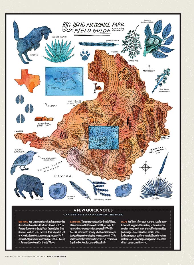
Driving: You can enter the park at Persimmon Gap (from Marathon, drive 70 miles south on U.S. 385 to Panther Junction) or Study Butte (from Alpine, drive 80 miles south on Texas Hwy. 118, then follow FM 170 to Maverick Junction). An entrance pass, good for 7 days, is $20 per vehicle; an annual pass is $40. Gas up at Panther Junction or Rio Grande Village.
Camping: The campgrounds at Rio Grande Village, Chisos Basin, and Cottonwood cost $14 per night; for reservations, go to recreation.gov or call 877-444-6777. All backcountry activity, whether it’s camping or backpacking or river-tripping, requires a permit ($10), which you can buy at the visitors centers at Persimmon Gap, Panther Junction, or the Chisos Basin.
Maps: You’ll get a free basic map and a useful newsletter with suggested hikes at any of the entrances; detailed topographic maps and staff-written guides (including a Chisos Basin trails booklet and a backcountry road guide) are available at the visitors centers. Louis Aulbach’s paddling guides, also at the visitors centers, are first rate.
View a larger image of the Big Bend Field Guide here.
In Praise of Camping
Three sites for the sleeping-bag rookie.
Though the Chisos Mountains Lodge is the only hotel within the park, you can also secure a roof over your head in nearby Terlingua (say, at the rustic but charming La Posada Milagro), Lajitas (where the green at Lajitas Golf Resort is restorative in its own way), and Marathon (premium linens and a walk-in shower at the Gage Hotel quickly melt away a long day of hiking). Still, to truly experience the West Texas desert, you’d do well to get down in the dirt at least a night or two. Here are a few sites that offer an easy introduction to tent and car camping in Big Bend. (A quick note about campfires: no ground fires are allowed in the park, illustration above notwithstanding.)
- Cottonwood Campground – Unlike the Rio Grande Village “cramp-ground” (which you should avoid unless RVs are your thing), this spot near the end of Ross Maxwell Scenic Drive is a blessed generator-free zone with plenty of shade. With 24 sites, and picnic tables and grills the only amenities, it’s a nice compromise for those unsure about leaving their cars. Pit toilets on site.
- Candelilla – This is desert car camping at its finest. Located on the southern end of Old Ore Road, with sweeping views of the Dead Horse Mountains, the primitive site is a quick 1.2-mile drive from the pavement, and you may not have to worry about high clearance (check with a ranger just in case). You’ll need a backcountry permit, but it’s a solo site, so you’ll have privacy.
- Juniper Flat – This forested plateau is only a mile from the Chisos Basin, which makes it ideal for novices and families to practice backpacking, pitching tents, and using a camp stove (not to mention the logistics of relieving oneself in the woods). A quick climb leads to three sites, each with its own charms and quirks. Backcountry permit required.
A Few Reasons to Wander
Because it’s not every day you get out to West Texas.
- Big Bend Ranch State Park – It may be less than half the size of the national park, but at 486 square miles, it is our largest state park and—with its deep canyons, volcanic mountain ranges, 238 miles of multiuse trails, and preponderance of zone camping (i.e., no designated sites)—well worth a visit, especially when Big Bend starts to feel just a little bit crowded. Get oriented at Fort Leaton or the Barton Warnock Visitor Center before hitting the backcountry.
- Fort Davis – The Fort Davis National Historic Site, a well-preserved Army outpost from 1854, is a must for history buffs, and nature lovers will appreciate the wildlife-rich hiking trails at Davis Mountains State Park, just three miles from town. But the must-stop is McDonald Observatory, atop Mount Locke, where state-of-the-art telescopes and star parties offer a new understanding of the universe.
- Alpine – Check out arrowheads from the Livermore Cache and one of the state’s largest collections of maps at the Museum of the Big Bend, on the Sul Ross State University campus, then peruse the eclectic array of saddleries, jewelers, and galleries on Holland Avenue. Finish with craft beer at Big Bend Brewing Company, which opened in 2012.
- Stillwell Ranch – Hallie Stillwell was a sharpshooting rancher who later served as justice of the peace for Brewster County. Today the general store on her legendary spread, just seven miles from the park’s entrance at Persimmon Gap, is a welcoming place to gas up, grab a cold drink, and hear stories of the olden days. (Also, there’s free Wi-Fi!) Don’t skip Hallie’s Hall of Fame Museum.
- Balmorhea State Park – The spring-fed swimming hole here is nearly two acres and stays an average of 74 degrees year-round. Its clear waters are a draw for landlocked scuba divers, though even casual swimmers will be able to spot tetras and catfish. Restored cienegas, rare desert wetlands, provide habitat for endangered gambusia and migratory birds.
A Report on Mountain Lions
Just How Many of the Famed Cats are in Big Bend?
Only the very lucky—or the extraordinarily unlucky—see a mountain lion in Big Bend. Since 2004 there have been just over twenty confirmed encounters, ranging from a few close-up sightings to the rare attack. These days, even wildlife biologists using trained hounds have a hard time locating the elusive Felis concolor. Louis Harveson, the director of the Borderlands Research Institute for Natural Resource Management at Sul Ross State University, calls them “ghosts.”
Harveson should know: he and a research team are undertaking the first comprehensive Big Bend mountain lion study in almost three decades. In early spring I joined the researchers, including Nick Smith, an expert tracker, and a graduate student named Price Rumbelow on a fact-finding trek on the west side of the park. In the wash below the ruins of Sam Nail Ranch, we counted a few tracks, and Smith’s dogs led us to the site of a spring where we bagged six-inch turds flecked with the fur of javelinas, a favored source of protein. DNA in the scat would be analyzed to help determine how many cats, resident and transient, frequent the Chisos Mountains.
Among other goals, the researchers aim to establish the first cougar census since 1988, evaluate the park habitat, and study predator-prey interactions. Their survey, which continues into next year, will also help predict the likelihood of maulings, to help prevent attacks like the one in 2012 on six-year-old River Hobbs. After the boy’s father stabbed the cat with a pocketknife, park authorities called Smith to help catch it (the cat was killed; the boy required seventeen stitches but recovered). “She was an emaciated female,” explained Harveson. “She was starving, desperate, and made a bad choice.” The drought has had consequences on prey and predator populations alike.
This was evident on our hike. After many hours of trudging, the five of us returned to our vehicles without seeing a single feline in the flesh. But Harveson was hopeful. The wet winter had boosted rabbit, rodent, and deer numbers, which would no doubt fortify more than a few mountain lions. Better luck next time.


