
With each pull of the paddle, my board glides quietly, leaving ripples at its tail. As I move just past Morgan’s Point, at Belton Lake in Central Texas, the only sounds are the gentle plunk of each stroke and the subtle swish that moves me ahead. I approach a flock of American coots floating along the banks, looking apprehensive with their plump, round gray bodies and white beaks. As my board breaches their congregation, they run alongside me, slapping their feet at the surface of the water before lifting off in unison to land several hundred yards ahead. We do this dance a couple times, but then they settle with some safe distance along the sides of my board, allowing me to move ahead.
For me, paddleboarding is meditation. In the repetition of four strokes on the left, then four on the right, I enter a flow state in which it’s just me, the board, and the water. I’m immersed in the sounds of birds, frogs, maybe lapping waves, and rustling leaves or the whispering of coastal grasses and reeds. When I started paddleboarding in Austin in 2015, I was one of a handful of residents practicing the sport on Lady Bird Lake. Now there are thousands who gather in a “floating bacchanal” known as Party Island. That social scene has its appeal, but my love of the sport is anchored in chasing solitude.
So I tied my board to my roof rack and hit the road in search of tranquil rivers, lakes, and coastal stretches. As always when exploring nature, safety comes first. Make sure to bring backup fins and a fin key tool set, and scope out a safe patch of shoreline where you can stop in the event of an emergency or equipment failure. If the forecast predicts winds above 15 miles per hour, it’s best to reschedule. As we move into late spring and summer, it’s also a good idea to check water levels in rivers and lakes when choosing a destination. The United States Geological Survey website offers real-time water-level reports. Generally, if levels drop below two feet frequently, it won’t be a very pleasant ride, or, at least, it will require a lot of maneuvering and more advanced skills.
Texas Parks and Wildlife has mapped 79 paddling trails across the state, and it would take a lifetime to explore them all. Here are five favorite trails I’ve explored, ranging from easy access to more challenging water conditions.
Aransas National Wildlife Refuge Paddling Trail
While the Aransas National Wildlife Refuge isn’t home to an official Texas Parks and Wildlife paddle trail, it’s certainly one of the most gorgeous, untouched stretches of the Texas Gulf Coast. The clean shoreline hugs pristine wetlands teeming with wildlife that use this safe haven to feed, breed, and nest before continuing on their migratory routes. En route, I came across another paddling trail marked by a brown sign just south of Cuero along FM 236. I also came across a feral hog, so I opted out of walking down to the water’s edge alone—but if I’d had a companion, I would have definitely explored this lush stretch of the Guadalupe river. If you plan to explore this site, I recommend the two-car strategy. Park one at the pullout site so you can traverse the river without having to paddle back upstream.
Many visitors to the refuge are birders and tourists who drive through to take in the coastal wetlands from the comfort of their cars on a one-way auto path. But less than a mile from the one-way loop, at the Fishing Pier, there is a small grassy patch beside a picnic area with a stretch of beach from which to launch. If the wind report is higher than 12 mph, I highly advise not going. On the day I arrived, wind speeds reached 36 mph, and my board almost blew out of my hand.
Since the refuge is home to a large alligator population, it’s strongly advised to launch from the kayak launch site only. Alternatively, Hopper’s Landing in Austwell is three miles north of the wildlife refuge entrance. This tiny coastal village offers a bait and tackle shop, a restroom, and a grassy picnic area with free bay access. You can reach the refuge wetlands from here, but it will add about thirty minutes to each direction of your journey.
Hot Springs Canyon in Big Bend at La Clocha
To SUP down any part of the Rio Grande without taking a tour is an adventure that requires serious preparation. For starters, it’s really not worth making the trip unless you plan to stay two nights at a campsite. Hot Springs Canyon is more easily accessible than the widely sought-after Mariscal and Boquillas. While the canyons here are dramatic and beautiful, the water level can be unpredictable. Hot Springs and San Vicente are fed by underground springs, which make them ideal destinations even when other parts of the river run dry. From Maverick Junction, the forty-mile drive to the La Clocha and Gravel Pit campgrounds takes about an hour. If you can manage a full weekend, arrive at the campsite the night before, set up and get some rest, do an all-day paddle the next day, then pack up and head out on the third day. The water here is relatively calm and is friendly for all levels, without any major rapids. The shallow parts may require you to get off your board and lift the fin (watch out for snakes). For SUPers, this is the most idyllic stretch of the Rio Grande.
Morgan’s Point Resort at Belton Lake
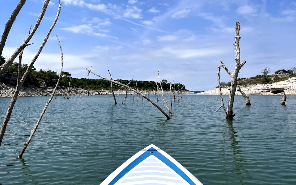
Amid the Blackland Prairie just west of Temple is Belton Lake. This time of year, the shores are teeming with birds and wildflowers. When there’s no wind or just a little, this Central Texas lake offers calm waters ideal for cadence and endurance paddling. Limestone cliffs loom beneath lake houses perched upon the bluffs. Westward, the shoreline gives way to beaches and grassy picnic areas—making the lake a friendly destination for novice and more advanced paddlers alike.
Though the lower waterline has left the boat ramps unusable, this vast lake still offers miles of paddling trails. Midweek the lake is very quiet, but hugging the shoreline is best to minimize the impacts of wind and stay out of the way of motorized boats. The reservoir becomes deep just ten to fifteen feet off the shoreline. If you find yourself at Morgan’s Point Marina, know that the waterway is a steep drop from the original boat ramp. While you can scuttle down to the lakeshore (grippy shoes advised), the boat docks are off limits for public use, and midweek the marina bathrooms are locked. From here, if you travel southeast toward the narrower coves, you will share the water with fishermen and waterfowl while armadillos mosey along the banks and deer feed in the lakeside brush.
Along the lake margins of Tanyard Branch, old, dead trees poke their white and black branches out of the water. When navigating around these trees, look intently to make sure nothing is protruding beneath the surface, as submerged branches can catch the board’s fin and knock you onto your knees or off the board. Another easier access point nearby is Camp Kachina.
Port O’Connor Boat Ramp to Sunday Beach
The coastal inlets along the interior of Matagorda Island offer miles of paddling trails that weave in and out of Espiritu Santo Bay from Port O’Connor. Be cautious of windy weather, wear plenty of sunscreen, and bring bug spray. These trails offer incredible sightings of whooping cranes and herons that feed among the flats and cock their heads when you paddle by.
While these trails are beautiful, they require a little bit of tough skin. Locals are accustomed to the humidity, windiness, and buggy coastal climate, but those of us visiting from other parts of the state would be wise to prepare before heading over. These waters are not friendly to quick drop-ins, unless you’re opting to take a tour with a guide, so be sure to bring a life jacket and a dry bag, as well as a water-repellent GPS if you’re going for a longer adventure. While the trails may look manageable on the map, this is big, wild water, and the environment is mostly in charge.
Wilbarger Paddling Trail (Utley)
Thirty-five minutes east of Austin, Webberville Road turns into Farm-to-Market Road 969. Just past Utley, next to the Colorado RV Park, is the Utley Bridge access point. The steep, paved boat ramp now sits about fifteen feet outside of the water, but an easy walk down to the muddy rock bed offers access. The water deepens gradually, it’s best to put your board in tailfirst so the fin can clear the bottom. The current is ever present here, as the lower Colorado River remains in steady flow.
For solo paddlers, venturing upriver toward McKinney Roughs Nature Park at Wilbarger Bend sets up an ideal six-mile round-trip excursion. The water is mostly deep enough to paddle all the way through, with a couple of rapids where the current intensifies and the riverbed becomes shallow. But paddling upstream offers a pleasant cruise back to your car during the return. If you’re going with a friend, you can leave a car at Fisherman’s Park in Bastrop and paddle down the river about fourteen miles.
Upstream, stretches of water look calm, and the pace of the rapids can be observed by noting how the river moves around scaly tree trunks poking out of the water. When the water grows more turbulent and the surface ripples, the riverbed is shallow and rocky. A pro tip is to reach out farther with the paddle and try to touch the river bottom. If it hits, it’s best to get on your knees and paddle faster closer to the surface to get through the rapid. Standing up in these stretches of river with a fixed fin is almost guaranteed to knock paddlers to their knees or send them off the front of the board. Once past the rapid, it’s safe to return to a slower cadence and stand back up. Songbirds, sheep, Longhorn cattle, and deer watch from the privately owned shoreline.
- More About:
- Water


