
Thousands have lived without love, not one without water,” wrote W. H. Auden of life’s essential element—and the only known antidote to Texas’s searing summer days. Fortunately, there’s no shortage of curative spots to baptize oneself in come June, whether you want to be fully immersed or just skim the surface.
In fact, thanks to the mid-century dam-building frenzy, Texas has nearly two hundred reservoirs, a number large enough to challenge Michigan’s claim as the Great Lakes State (Michigan’s are bigger, but we have more). Huge underground pools feed springs that bubble up across the Edwards Plateau (think Barton Springs) and the Trans-Pecos (Balmorhea). More than 80,000 miles of rivers and streams crisscross the state, from the Rio Grande to the Sabine, while the Gulf Coast shoreline stretches some 360 miles.
Such an embarrassment of riches is prone to overwhelm would-be water-goers, so I spent the spring scouting new waterways and vetting old classics. I paddled rivers east and west, splashed in desert springs, and swam in hidden lakes. I caught fish and combed beaches. I came away with nineteen watery prescriptions to cure what ails you—whether you’re in need of some inner tube R&R, a raucous romp, or a rugged, adrenaline-infused adventure. In addition, I’ve assigned each trip a difficulty rating so that urbanites and parents don’t have to guess at logistical challenges. The somewhat subjective color scale takes into account distance from amenities (i.e., food and restrooms and campsites), amount of courage necessary, and likelihood of minor mishaps. Green means you can pretty much grab a towel and go. Red means peril. But enough with the explanations. It’s time to unstick your legs from your seat and get thee to water!
Relax

1. Balmorhea State Park, Toyahvale
Best for: Swimming (though you can snorkel and scuba too!)
Difficulty level: Child’s play
Pro Tip: Good news! Later this year, Texas Parks and Wildlife will renovate the park’s rundown heritage motel, San Solomon Springs Courts.
The San Solomon Springs, in far West Texas, have been a pilgrimage site for generations of otherwise unlikely desert travelers—namely, scuba divers, who come to mine the clear waters of Balmorhea, the thirties-era Civilian Conservation Corps–built swimming hole into which the springs feed a seemingly impossible fifteen million gallons of water a day.
Still, you don’t have to dive deep to appreciate the refreshing waters, which stay between 72 and 76 degrees year-round. Indeed, a recent visit found most of the action along the edges of the 1.75-acre pool, where sunbathers on inflatables floated alongside splashing grommets. Meanwhile, below the surface, endangered species such as the Comanche Springs pupfish and Pecos gambusia swam about. Sure, it can feel like an aquarium, but, as the scuba crowd insists, that’s part of the fun.
Getting there: The park is located 4 miles southwest of Balmorhea on Texas Highway 17 (open daily 8–7:30, or sunset; $7, under 13 free, camping from $11; 432-375-2370).


2. I.B. Magee Beach Park, Port Aransas
Best for: Fishing
Difficulty level: Child’s play
Pro Tip: You can camp in the sand at Magee, but you don’t have to…resorts abound. The beachfront Mayan Princess is a fave.
To experience the soft sands and laid-back allure of the so-called Texas Riviera, many head for Mustang Island State Park. But I gravitate toward Port Aransas’s I. B. Magee Beach, a smaller Nueces County park at the island’s north end.
Like Mustang Island, I. B. Magee—named for a local sportsman—has primitive camping right on its sugary shores and developed RV spots nearby. In summer, the park, protected by a long rock jetty, hosts Texas Surf Camps, organized by local pro Morgan Faulkner and sponsored by the apparel company Body Glove. Anglers congregate at the 1,240-foot Horace Caldwell Pier to catch sea trout, drum, shark, and tarpon. All of the Nueces County beaches are in the midst of a $5 million sprucing-up that will also enhance storm protection.
Getting there: From North Alister Street, turn onto Beach Street and continue for a half mile to the seashore (beach camping is $12; pier access is $2; each fishing pole is $2; 361-749-6117).
3. Boykin Springs Recreation Area, near Jasper
Best for: Swimming
Difficulty level: Easy
Pro Tip: If even modest crowds get you down or you strike out on campsites, there is free primitive camping and swimming close by at Bouton Lake.
We can thank settler Sterling Boykin, who died in 1871, for discovering these springs behind the Pine Curtain. We also owe him for damming a nearby creek and creating a nine-acre swimming hole that’s so hidden in the Angelina National Forest that I’m almost reluctant to say much more.
“Places like Boykin are a time capsule,” a spokesman for the U.S. Forest Service told me. In the thirties, the Civilian Conservation Corps built the campground at the Boykin homestead, and a decade later, the Texas state militia used these woods for training. Hurricanes Rita and Ike prompted the Forest Service to clear some older trees, but the area retains a primitive allure.
Boykin Lake pours over a stone spillway, a sloping boulder-and-concrete channel where kids can splash and explore. There’s also a wending, two-and-a-half-mile trail that follows the creek to an old sawmill. Afterward, soak your feet—and maybe the rest of your body—in the cool spring water.
Getting there: From Jasper, take Texas Highway 63 west 18 miles to Forest Service Road 313. Follow 313 for 2.5 miles. Note: there is not a ranger station at this site (camping $6 per vehicle; 936-897-1068).

4. Barton Springs Pool, Austin
Best for: People-watching
Difficulty level: Child’s play
Pro Tip: Pro tip: Make time to hike the dappled trails of the Barton Creek Greenbelt, one of the wildest urban treks in America.
Last year, more than half a million swimmers dived into Barton Springs, and on the scorching afternoon of my last visit, seemingly all of them were lined up outside the chain-link fence, waiting to clear the cashier. Indeed, if a backside parking spot hadn’t miraculously opened, I doubtless would have broken my promise to my eight-year-old daughter, Ursula, to join them at Texas’s favorite swimming hole.
Getting there: Parking available at Zilker Park or off Robert E. Lee Road (open daily 5 a.m.–10 p.m., except Thur, when it’s closed for cleaning 9–7; admission charged 8–9, resident adults $3, non-resident adults $8, discounts for children and seniors; 512-867-3080).Always a brisk 68 to 70 degrees, the enormous concrete-surrounded pool is an astonishing engineering feat, capturing water bubbling up from the Edwards Aquifer, which discharges between 10 million and 80 million gallons a day. Ursula squealed when she hit the water and swam into my arms. As the waters washed over us, I was delighted that for all the changes the state capital has seen, Barton Springs—brimming with tattooed hipsters and old-school hippies—still reflects the soul of Austin.
5. Matagorda Bay Nature Park, Matagorda
Best for: Beachcombing
Difficulty level: Easy
Prop Tip: If beach camping isn’t your speed, check out the Lodge at Karankawa Village.
I didn’t find high-rises, much less a single thatch-roofed palapa, at the coastal mouth of the Colorado River midway between Galveston and Port Aransas (well, maybe one—the Poco Playa restaurant and shops six miles inland). What I did find was a surprisingly peaceful hideaway, where the Lower Colorado River Authority maintains a 1,600-acre park and nature preserve popular with anglers, birders, and beachcombers.
Fortified by a picnic, I scoped the makeshift kayak trails along FM 2031—for now, the only way to reach the tidal estuaries. The LCRA plans to increase access to these fishy marshes, but it was the park’s wild charm that won me over.After camping among the sea oats near the dunes along a two-mile stretch of beachfront adjacent to the park (the beach continues 21 miles to the east, most of which can be enjoyed by savvy off-road drivers), I joined a free guided morning nature walk along the beach, sorting whelks, sand dollars, and angel wings left by the receding tide.
Getting there: From Matagorda, take FM 2031 for 6.5 miles south to the Gulf. Beach access is available directly from the LCRA. Park near the jetty, or double back to Beach Road to reach the sand by vehicle (camping from $10, camping with hookups starts at $25; primitive beach camping is free; 979-863-2603).

6. Hamilton Pool Preserve, near Austin
Best for: Gazing
Difficulty level: Easy
Pro tip: Explore the lakes, hills, and rivers at nearby Reimers Ranch.
Of all of Texas’s cinematic beauties, few rival Hamilton Pool, just a short distance from the Pedernales River. Here, waters from twisty Hamilton Creek plunge fifty feet from a semicircular cliff into a natural sinkhole that was formed by subterranean currents thousands of years ago. The falls sometimes shrink to a slight dribble but never cease, riffling a cool celestial pool of aquamarine that has drawn swimmers for centuries.
Getting there: From Austin, take Texas Highway 71 west 12 miles to Hamilton Pool Road (open daily 9–6, $15 per vehicle). Reservations required from May 15 through September ($26 per vehicle per morning or afternoon slot). Check the website or call 512-264-2740 for updates on pool closures and water quality.Such stardom comes at a price, however. This spring, to control visitation and help protect endangered species like the golden-cheeked warbler, Travis County announced a new online reservation system. And even though swimming was closed the day I went—as it sometimes can be due to weather and, disconcertingly, bacteria—the crowds were thick. The new rules should keep the pool from being loved to death.
Play

7. Comal River, New Braunfels
Best for: Tubing
Difficulty level: Easy
Pro tip: Avoid the crowded public exit by renting from Rockin R, which has a private access point with shuttle service.
Confession: I’m not crazy about tubing—the crowds, the vinyl rash, the suspicion that I’m soaking in a stranger’s urine.
The City Tube Chute section hooked me first: the concrete slide lasts some twenty seconds and concludes with a row of foot-high waves that upend ice chests and swipe sunglasses. Below this spillway follow two quick rapids, and then it’s all about chilling in the crystal current. That was definitely a skill I could stand to master.Then I cruised the Comal, the shortest navigable river in Texas. Its two-and-a-half-mile length is within the New Braunfels city limits, and though coolers are allowed, it’s generally not the floating frat party found on other area waterways.
Getting there: Prince Solms Park, at 100 Liebscher Drive, is a convenient entry point near the chute (from June to mid-August, open daily 10–7; $5 wristband to enter the park, tube rentals $7, $10 parking from Memorial Day to Labor Day). Or make reservations through Rockin R, at 193 South Liberty ($20 day pass including shuttles; 800-620-6262).

8. San Felipe Creek, Del Rio
Best for: Frolicking
Difficulty level: Child’s play
Pro tip: Nearby Bracketville is home to the third-largest swimming pool in Texas, at historic Fort Clark Springs Nature Resort, a private campground with a motel and stables.
By the turn of the century, the San Felipe was the home of an ice factory that the locals relied on to cool their beer and groceries. Though today the shady waterfronts are in need of a little TLC, the creek still runs clear and cold. A cluster of access points includes Horseshoe Park and the mini-falls downstream at Lions Park. Diving in, I spotted clusters of armored catfish eating algae among the rocks and recognized kindred spirits: water-loving critters grateful for this brisk oasis.In Texas’s early days, the route from San Antonio to El Paso was notoriously arid. One exception was at the western edge of the Edwards Aquifer, where ten limestone springs pump more than 50 million gallons of water a day into San Felipe Creek, forming the fourth-largest fountainhead in the state.
Getting there: The headwaters of San Felipe are on private land, so use the swimming holes found near I-90E and the Gillis Street Bridge (open daily 5 a.m.–10 p.m.). Snag a map at the City Parks and Recreation Department, at 309 Cantu Street.
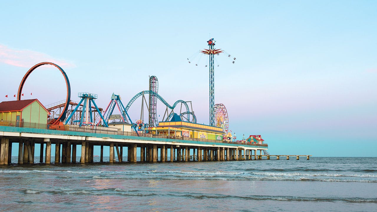
9. Galveston Seawall, Galveston
Best for: Sightseeing
Difficulty level: Easy
Pro tip: The two-thousand-acre Galveston Island State Park is a bird haven with hiking, biking, beaches, and bayside kayak trails.
Preferring to stoke my adrenaline with exercise, I paddled past the roller coaster and Ferris wheel, working to maintain my balance in the swells. Nearby, a dolphin knifed through a set of rollers, but my equilibrium failed as the waves shook and shuddered my board. Dripping but undeterred, I scrambled back to my feet.For all its haunted and tragic history—from the reign of pirate Jean Lafitte, in the early 1800’s, to the devastation wrought by Hurricane Ike, in 2008—Galveston retains a sunny spirit. This notion struck hard as I edged past the Pleasure Pier on a stand-up paddleboard. Texas’s answer to Coney Island reopened a batch of rides and restaurants in 2012 right where the original iteration stood before Hurricane Carla hit, in 1961.
What else could I do? After all, rebounding is a way of life in Galveston.
Getting there: The seawall extends 10 miles, with plenty of beach access. The Pleasure Pier starts at 25th Street (open daily; check or call 409-766-4950 for hours). Ohana Surf and Skate, between 28th and 29th streets, rents stand-up paddleboards and surfboards and offers lessons starting at $40 per hour (409-763-2700).

10. Blue Hole Regional Park, Wimberley
Best for: Swimming
Difficulty level: Child’s play
Pro tip: Only 250 visitors are admitted at a time. If you’re crowded out, head to Blanco State Park, half an hour away.
Approaching the lush picnic area, I was curious to see how Cypress Creek had weathered 2015. During the deadly Memorial Day floods, as the Blanco River raged through Wimberley, the beloved Blue Hole suffered only minor damage. Then came the Halloween flood, shredding vegetation and destroying the swimming dock along the creek.
Completed in 2012, Blue Hole, its clear waters swirling through sculptural limestone, retains an Edenic vibe, replete with butterflies and birdsong. At ten a.m., the quiet is palpable, but the crowd blossoms quickly with visitors from as far away as Russia and Germany, eager to swim alongside the resident fish.But such catastrophe seemed eons away this March as I traversed the hilly, oak-shaded trails through the persimmon bushes and hackberries above the spring-fed swimming hole. The limestone picnic tables stood steadfast, and the big bluestem and moisture-loving switchgrass thrived. Most of the century-old cypresses were still standing, as were the area’s two iconic rope swings. I attributed the swift recovery to the hard-won community acquisition of Blue Hole in 2005, which eliminated the threat of development and established a resilient park building plan.
Getting there: From the Wimberley square, take Old Kyle Road to Blue Hole Lane (open year-round, with swimming daily from Memorial Day through Labor Day, 10–6; $9, $5 for ages 4–12 and seniors 60 and up, under 3 free; 512-660-9111).
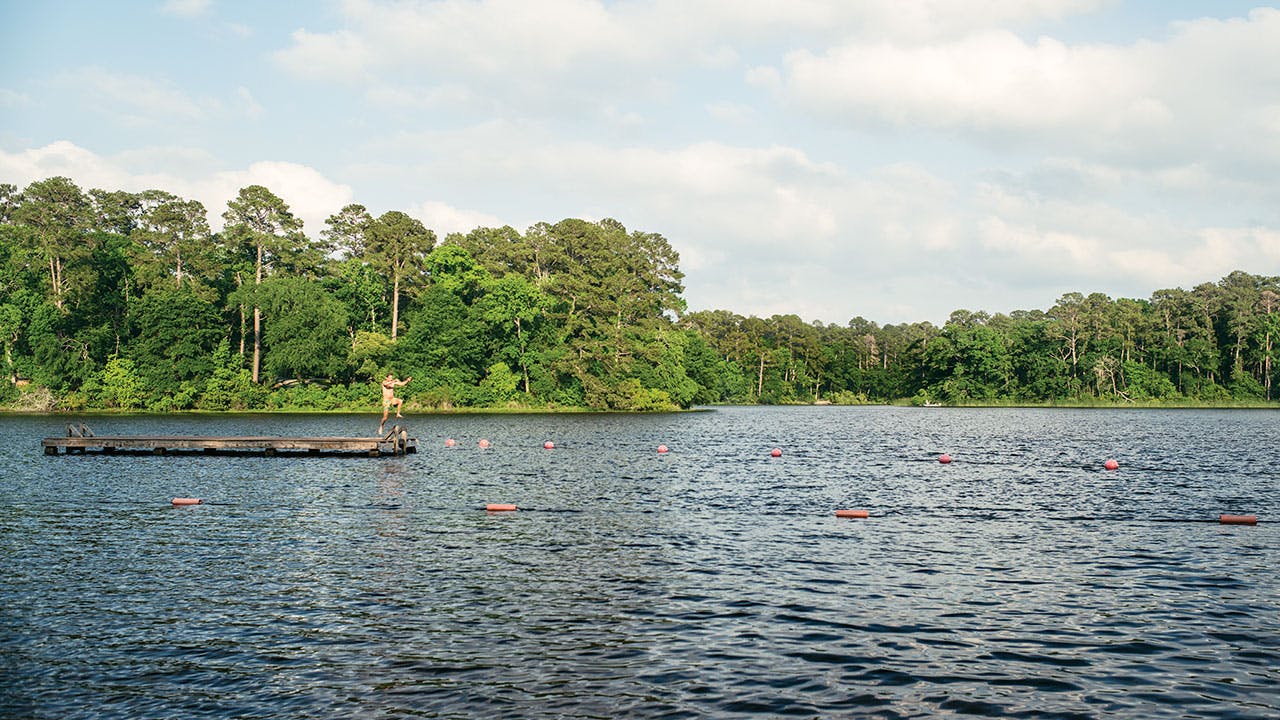
11. Lake Raven, Huntsville
Best for: Camping
Difficulty level: Easy
Pro tip: Stop by the Sam Houston Statue Visitors Center to see seventy-foot Big Sam.
Twenty-one miles of trails offer hiking, mountain biking, horseback riding, and a chance to glimpse some of the 250 species of birds that have been seen in the park. But come summer, my main target remains the creek-fed, 210-acre Lake Raven, with its artificial beach of gently sloping sands. A concessionaire rents canoes, and the sunfish and bass are abundant and hungry (snag bait and more at the Gator Junction shop). Fortunately, motorboats must maintain wakeless speeds, and the local gators haven’t even been known to attack.It’s the hush on the shores of Lake Raven, an hour north of Texas’s largest city, that keeps me coming back. The lake forms the trefoil heart of Huntsville State Park, a shady woodland bedecked with Spanish moss and surrounded by more than 160,000 acres of the Piney Woods that make up Sam Houston National Forest.
Getting there: Six miles south of Huntsville, take I-45, then take exit 109 and follow Park Road 40 ($5, under 13 free, camping from $15; 936-295-5644)

12. Isla Blanca Park, South Padre Island
Best for: Surfing
Difficulty level: Moderate
Pro tip: Salute the surf goddesses at the Wanna Wanna Beach Bar & Grill on the sand, but call a cab if you indulge in their “turbo” piña colada.
Fortunately, I’d arrived during the tourism lull before spring break, so nobody was around to see me stumble. Indeed, solitude was the rule rather than the exception over my two days exploring some of Texas’s whitest, brightest beaches. The previous day, I drove right onto the sand, north of town at Edwin King Atwood Park, where off-roaders and anglers cruise an epic 27-mile undeveloped reach of the island, taking day trips to the Mansfield cut that splits SPI from Padre Island National Seashore. Not wanting to strand my rental car, I drove only a few miles. The Gulf breezes and sunshine were downright Caribbean.Belle Daigle, a 22-year-old surf instructor from Island Native Surf House, popped onto her board with ease and then told me to try the move. We were practicing on the sand, yet despite Daigle’s assurances that I’d “get up” by lunch, I couldn’t envision doing anything but face-planting—and frequently—into the Gulf of Mexico.
Getting there: Cross the Queen Isabella Causeway and turn right on Padre Boulevard ($4 per vehicle, $18 for a 30-day pass, camping from $15; 956-761-5494). A 1.5-hour surf lesson from Island Native costs $40 (956-772-7100)
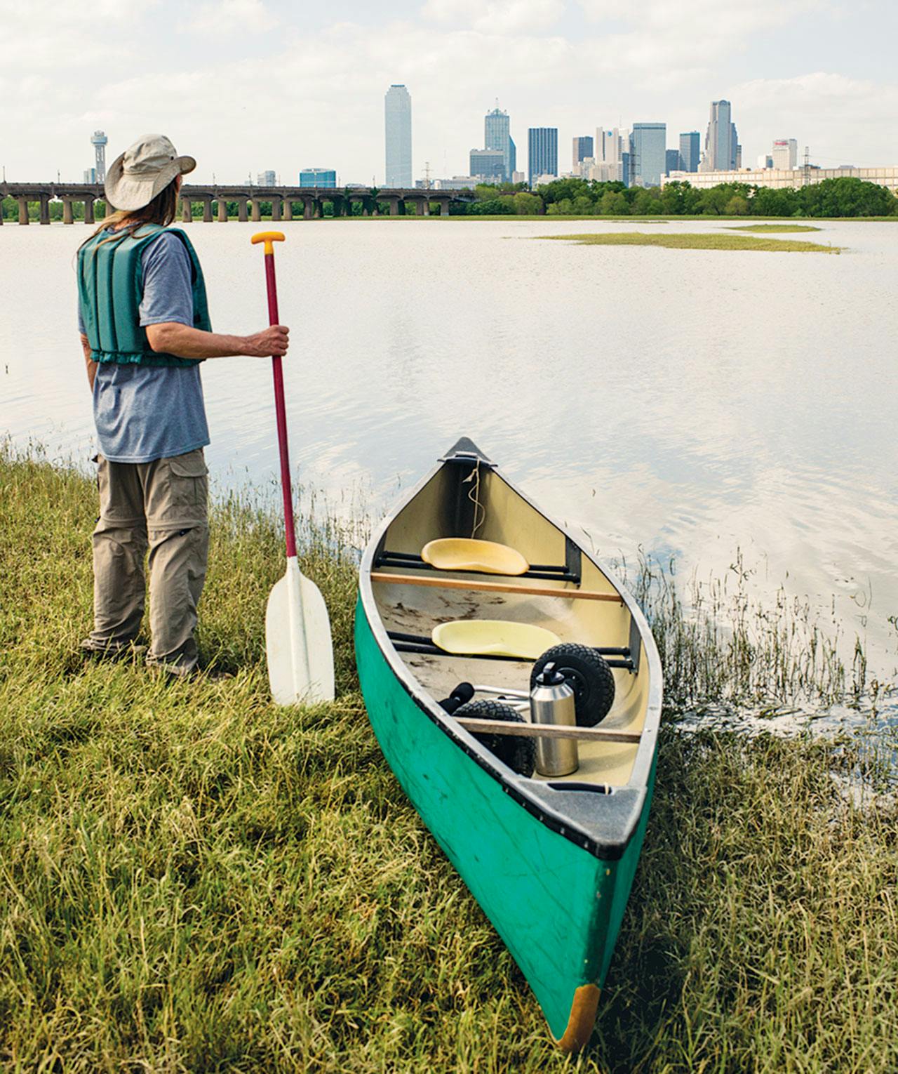
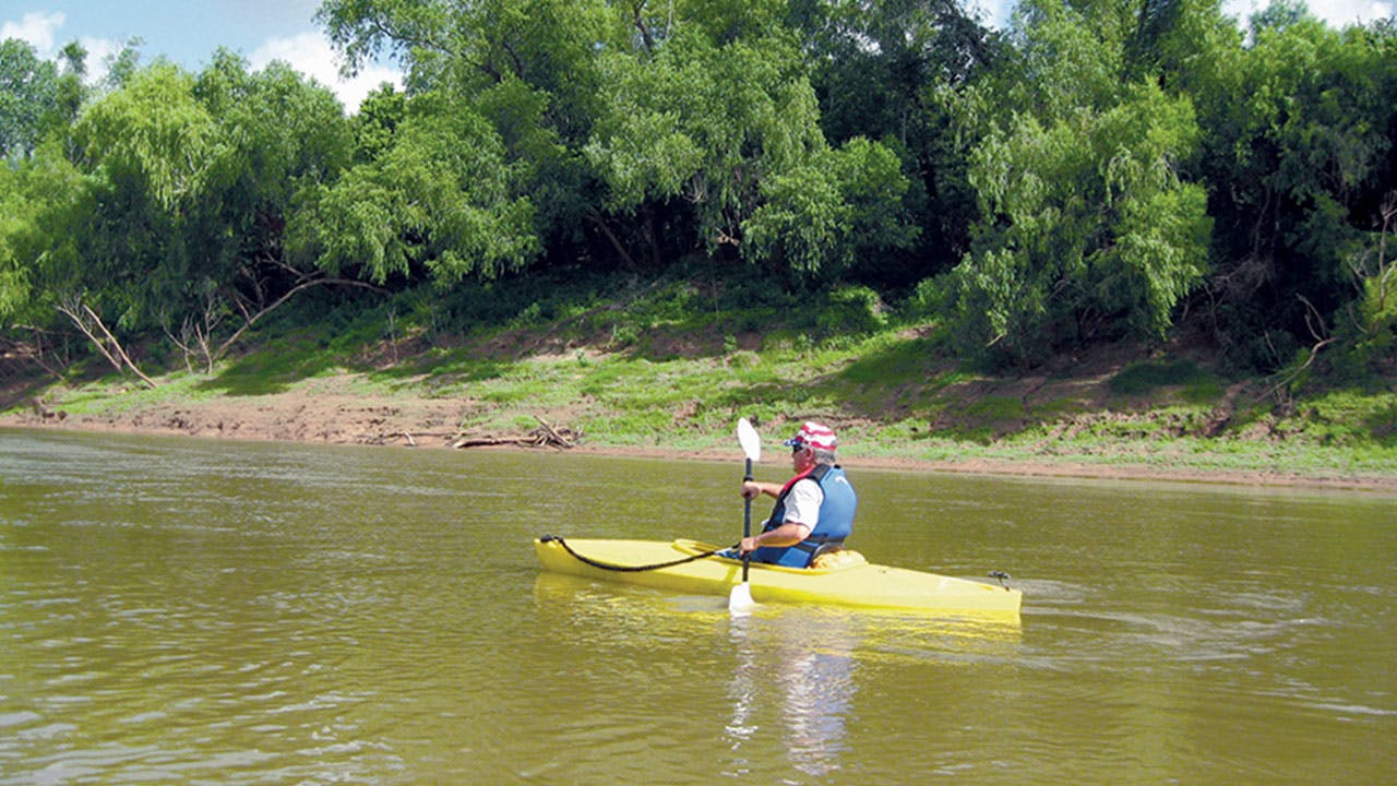
13. Trinity River, Dallas
Best for: Paddling
Difficulty level: Moderate
Pro tip: Learn more about the region’s ecology at the Trinity River Audubon Center.
This winter, the city of Dallas finally concluded that the malfunctioning Dallas Wave, a $4 million engineered white-water rapid on the Trinity River, must be removed or repaired. Outfitter Charles Allen, who has guided paddlers down the river for a quarter century, couldn’t be happier.
Getting there: From I-35E, take exit 426B. Head east on 8th Street to Santa Fe Avenue. Park at the DART overflow lot, at 1837 E. 8th, and follow the trestle trail to the boat launch. To reach the takeout, take I-45S to exit 280 and follow E. Illinois Avenue to the river. Trips with Allen cost $50 per person (214-941-1757).Just downstream of the Wave, on the main stem of the Trinity, is one of Allen’s favorite places, though he can suggest alternatives for days. Starting within view of downtown’s gleaming skyscrapers, the trip leads six miles past pale Cretaceous-era formations called Austin Chalk and the six-thousand-acre Great Trinity Forest, the largest grove of urban hardwoods in the country. Benign neglect creates sights money can’t buy.
Explore

14. Lower Pecos River, near Pandale
Best for: Extreme paddling and backcountry camping
Difficulty level: Grueling
Pro tip: Doing this trip in less than a week mean missing rock art tucked into the side canyons and bypassing fishing holes up and down the river; eight days is ideal.
“If something goes wrong, don’t try and walk out. My best advice is keep paddling.” Those words of wisdom came from Jack Richardson, known as Pecos Jack, a former river outfitter and the co-writer of the indispensable guidebook The Lower Pecos River, Pandale to Lake Amistad. I met Richardson at his spread outside Houston, hoping to find a boat suitable for a six-day, sixty-mile run down the Pecos River, as remote a stretch of water as any found in the state.
My five crew members and I already had two canoes and a pair of kayaks, but our inability to go easy on food and beer left us needing more cargo capacity. Unfortunately, Richardson’s canoes were blistered and patched to the point of being next to useless, especially if something did go wrong—which was likely.
After all, the Pecos has a reputation for wreaking havoc. It’s filled with treacherous features with names like Pin Rock Rapid and Waterfall Rapid. At low flows, we would face a brutal seven-or-so-mile stretch known as the Flutes, where even the most experienced paddlers must drag their canoes over rough limestone. If it rained, deadly flash floods were another possibility.
Still, even before I first saw the Pecos, I had long been drawn to its mythic status as a place where the law of the land was the only law that mattered. “The course of the Pecos appeared only as a dark meandering line,” Zane Grey wrote in the thirties, “its walls hidden, its presence sometimes mysteriously vanished.” Long after the close of the American frontier and the emergence of Google Earth, the twisted desert chasms traced by the river remain virtually unknown.
A couple weeks later, having secured a third canoe, we loaded everything into my companions’ pickups and headed west. En route, we rendezvoused with the shuttle drivers who would deliver our trucks from Pandale Crossing, where a low concrete bridge spanning the stream offers the only public access to the lower Pecos, to our destination on Lake Amistad, just a few miles above the U.S.-Mexico border.
We had all been down rivers before. But nothing prepared us for the Pecos. Tracing the eastern fringe of the Chihuahuan Desert, it runs through remote canyons bounded by private ranches. After we ricocheted through the first few rapids, any lingering ambivalence about our preparedness took a backseat to our sense of adventure. We surged through stands of giant cane, awakening clouds of gnats. Waves splashed over our gunwales, floating anything not strapped down. In short order, we beached the boats to dump excess water and keep from capsizing.
Over time, we began to measure our lives against the legacy of the ancients, predecessors of the Apache and Comanche, finding breathtaking vistas largely unchanged since these cliffs were their home. With two days to go, we camped at the aptly named Painted Canyon (inset), on a series of ledges above a gnarly rapid that dropped between several house-size boulders. That night, we sipped whiskey around the campfire and counted the stars. In the morning, we carried our gear downstream and used ropes to guide the boats through the rough water.The farther from civilization we traveled, the more profound our experience grew. We tumbled through more rapids and one night took shelter in our tents from a freak thunderstorm. Despite the downpours, the river never threatened to flood. Meanwhile, we enjoyed hard-won rewards: tracking soaring hawks, catching beefy largemouth bass, dipping our tired bodies in turquoise pools fed by sparkling springs. As we surveyed four-thousand-year-old rock-art figures—the area has one of the highest concentrations of pictographs on the planet—a strong camaraderie took hold. This we could handle.
I wish I could report that we arrived at Lake Amistad in total sync with nature, but that’s not accurate. The river remained a puzzle, its hazards keeping us on our toes and ever debating our options. In the end, we focused as much on what had gone wrong as what had gone right and how we would tackle it again in the near future.
Getting there: Hiring a shuttle driver to deliver your car downstream is crucial if you intend to see your vehicle again. Comstock-based Emilio Hinojosa (830-317-0760) charges $150 per car. A mile west of Comstock, take Ranch Road 1024 north about 60 miles to Pandale Crossing.
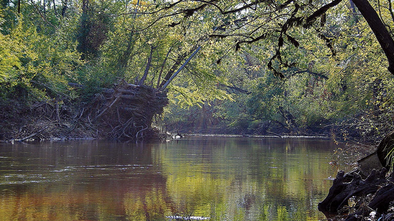
15. Village Creek Paddling Trail, Silsbee
Best for: Paddling
Difficulty level: Moderate
Pro tip: Longtime local outfitter Perry Humphrey, of Eastex Canoe Trails, rents canoes and kayaks and provides a shuttle (from $20).
Back in 2010, this 21-mile tributary of the Neches River was dedicated an official Texas Parks and Wildlife paddling trail. Nevertheless, I had the East Texas stream to myself this spring—unless, of course, you count the critters.
Sundown arrived as I dragged my canoe up one of the many sandbars that make for exquisite camping. As I pitched my tent, an otter scampered up the opposite bank, a friendly presence on an otherwise lonely evening.Launching my canoe from the FM 418 access above the Nature Conservancy’s 5,700-acre Sandyland Sanctuary, I chased a gentle series of tea-colored oxbows down a dozen miles. Though most of the mature forest was logged decades ago, the Nature Conservancy and the Big Thicket National Preserve maintain remnant groves of sweetgum, bald cypress, and old-growth longleaf pine, which make for a primeval experience (and provide shelter for pileated, downy, and red-cockaded woodpeckers as well as many migratory warblers).
Getting there: The Village Creek access on FM 418 is below a bridge between the towns of Kountze and Silsbee. Take out at either the U.S. 96N boat ramp just north of Lumberton or Village Creek State Park ($3, under 13 free, camping from $7; 409-755-7322).
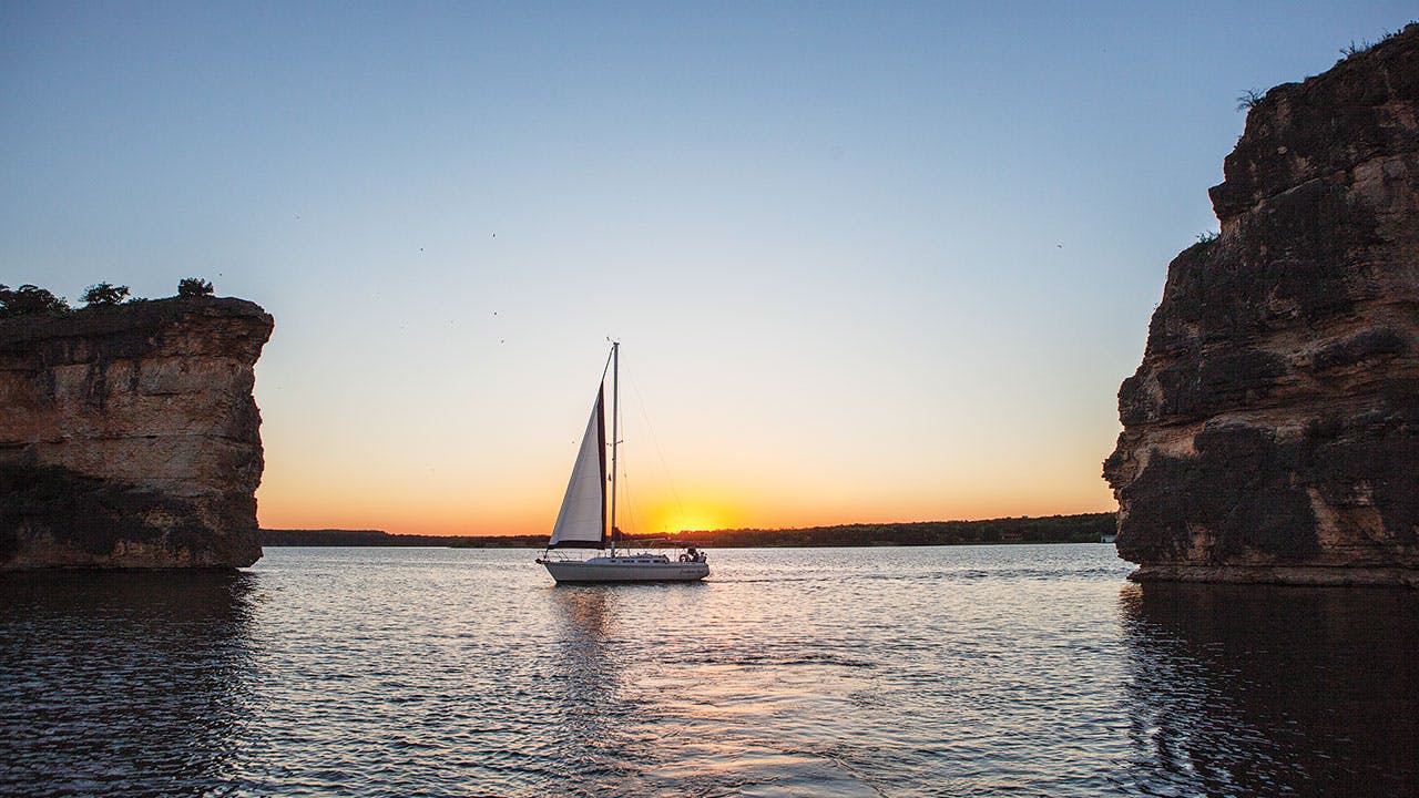
16. Possum Kingdom Lake, near Graford
Best for: Every possible water activity
Difficulty level: Easy
Pro tip: Lake temps can reach 80 degrees, but you’ll find cooler water below the Morris Sheppard Dam, where the Brazos River flows.
With soaring copper bluffs; sparkling, turquoise water; and more than three hundred miles of shoreline—almost as much as the entire Texas coast—there’s enough liquid fun at Possum Kingdom to make you forget the Toadies’ eponymous murder ballad/alt-rock hit.
Looking for a more peaceful experience, I headed to the eastern edge of the peninsula, where million-dollar mansions sit cheek by jowl with private camps belonging to the YMCA and the Boy Scouts. The six-mile spit is also home to several small Brazos River Authority “pocket” parks connected by a hike-and-bike trail with sites outfitted for camping, swimming, and picnicking. Cycling through the cedars from one end of the peninsula to the other, I stopped at Area #6. A popular swimming spot with a broad, sandy beach, I waded into the cerulean lake as a cigarette boat cruised past, its gentle wake lapping the shore before the distant Palo Pinto cliffs.Last summer, “PK,” as the locals call it, was one of the first Texas reservoirs to refill after Texas’s four-year drought. Sporty sorts returned in droves for boating, fishing, and—believe it or not—cliff diving. This month, Red Bull will commence its annual World Series event at PK, enticing professional daredevils to launch themselves from the 85-foot limestone formation known as Hell’s Gate. The rest of summer, the speedboat crowd ensures that the area remains one of the most raucous party scenes this side of Bourbon Street.
Getting there: To get to the PK peninsula, follow Park Road 36 to assorted public sites. Free, except North D&D Area #4 and Sandy Beach Area #6 from mid-May to mid-September (camping is $10; 940-779-2321).
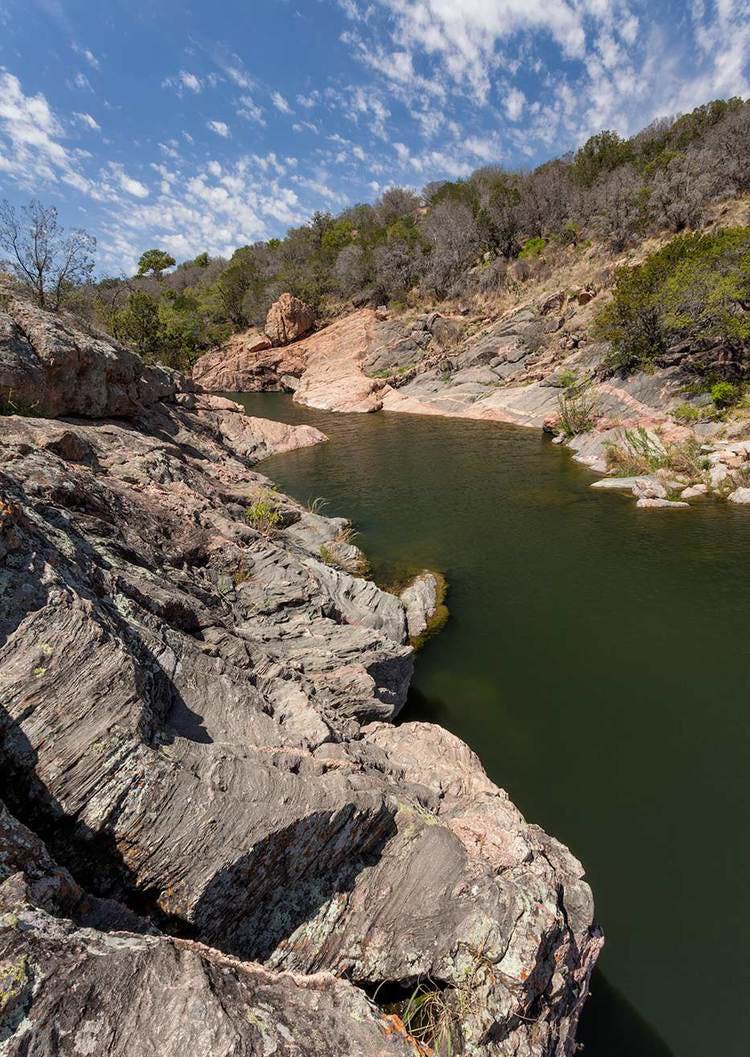
17. Inks Lake State Park
Best for: Exploring
Difficulty level: Moderate
Pro tip: As long as they stick to piers and park shorelines, anglers don’t need a license to fish for the plentiful sunfish and largemouth bass.
A quarter-mile stroll or a twenty-minute paddle (the park store rents kayaks) takes you to the park’s main attraction, the Devil’s Waterhole (below), so named by locals who thought the devil dwelled in the waters, making them hot.On the eastern edge of the twisted pink spine of Central Texas’s rocky Llano Uplift sits Inks Lake, one of the New Deal reservoirs that helped tame the Colorado River in the thirties. The modest 777-acre lake also happens to abut one of the prettiest state parks. Of the nearly two hundred places to pitch a tent, the lakefront sites offer the illusion of seclusion and postcard-perfect views of this oak- and pecan-studded Shangri-la.
Getting there: From Burnet, take Texas Highway 29 10 miles to Park Road 4. It’s 3 more miles south to the park entrance ($6, under 13 free, camping from $11, air-conditioned cabins that fit up to four can be reserved for $55).
18. Lower Brazos River, Sugar Land
Best for: Paddling
Difficulty level: Moderate
Pro tip: You can float to the bridge at FM 1462, but Yellowstone Landing, three miles earlier, is a better takeout, with plenty of nearby camping.
The guys were nervous about the distance. I was nervous about the scenery.This spring, I persuaded two Hill Country friends to join me for a thirty-mile paddle through the coastal prairies of southeast Texas. We gathered just after sunrise and aimed to reach the takeout before sundown.
After all, who would invite dudes from Austin and San Antonio to Houston for paddling? A half century ago, John Graves famously memorialized his trip down the upper Brazos before the river was dammed. But no such paean describes the river’s seldom-seen subtropical sweep toward the Gulf of Mexico, which runs broad and brown like a mini-Mississippi. So we were surprised that Graves’s Goodbye to a River also applied here. “The Brazos belonged to me that afternoon. . . . To me and the whistling birds and the unseen animals (deer and coon tracks overlaid each other in the shore’s silt) and to the big suckers that leaped and splashed.” Add the croak of a heron and Graves’s description could have been our own.
Getting there: Take two cars. Head to the Brazos Bend State Park visitors center first to get the gate code for Yellowstone Landing ($7, under 13 free, camping is $20; 979-553-5101). Park one car at Yellowstone Landing. In the second car follow signs to the put-in at the Brazos River Turnaround, beneath U.S. 59 in Sugar Land.

19. Lake Amistad Recreation Area, near Del Rio
Best for: Boating
Difficulty level: Challenging
Pro tip: After dropping to historic lows in 2013, Lake Amistad was at 75 percent capacity this spring, its surface area reaching 45,500 acres. It’s best to check with park rangers before heading out on the water.
Johnson eased up on the throttle and pointed. A six-foot panther with a curly tail leaped across the limestone cliff. The red-and-black pictograph at Indian Cliffs on the northeast shoreline is fearsome, yet not scary enough to keep the fishermen at bay. “We’re definitely known for our tournaments,” noted Johnson; trophy largemouth are regularly caught in these waters, some weighing more than fifteen pounds.Lake Amistad park archaeologist Jack Johnson and I motored across this huge reservoir spanning the U.S.-Mexico border. Formed by the Rio Grande, the Pecos, and the Devils River, the inkblot-like lake boasts more than eight hundred miles of shoreline.
With a kayak, you can reach secluded campsites along Big Canyon, near the Devils River inlet, as well as spots on the lower Pecos. A bass boat opens up endless possibilities. Castle Canyon and Governors Landing offer basic campsites and opportunities for landlubbers who want to swim or fish.
Getting there: Located 8 miles northwest of Del Rio and extending nearly 75 miles along the Texas-Mexico border, Amistad can be accessed from the north or south via U.S. 277/377 (open daily 8–4:30; lake-use pass for boaters $4 per day or $10 for three days, camping from $4; 830-775-7491).
- More About:
- Water


