
The Miniature Thru-Hike
Sam Houston National Forest
Route: Eastern section of the Lone Star Hiking Trail
Distance: 23 miles
Difficulty: Moderate. This is a fairly long-distance hike, and you’ll need to schedule a shuttle before heading out.
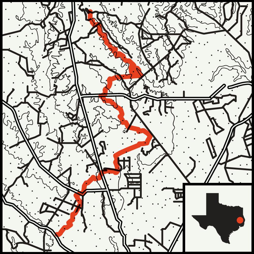 Few places in Texas offer the chance at a bona fide thru-hike: a multiday, long-distance end-to-end trek best experienced along epic trails like the Appalachian or the Pacific Crest, both more than two thousand miles long. Our state’s preponderance of private property has rendered those opportunities nearly nonexistent. But in East Texas, the 128-mile Lone Star Hiking Trail, the state’s longest continuous hiking path, offers at least a sample of what a thru-hike can feel like. Plenty of hikers come intent on knocking out the entire length in a week’s time, but I decided on a more modest adventure: 23 miles in three days.
Trailheads dot the whole route, which winds through Sam Houston National Forest, so hikers can dip in and out as they please, a piecemeal approach known as a flip-flop. I focused on three scenic sections—Big Creek, Tarkington, and Winter’s Bayou—that lead to the trail’s eastern terminus, just north of Cleveland. I arranged a shuttle from my car, which you’ll need to do for such a hike, and it dropped me off at the Iron Ore trailhead, where a clearing of tall grasses quickly turns into the dappled shade of the Piney Woods. Shouldering my pack, I soon left behind the traffic noises from the farm-to-market roads along the forest’s edge.
Survival Tip
If you forget your bug repellent, mix a little water with dirt to create an all-natural paste that will help keep mosquitoes at bay.
Unlike the wide-open skies and never-ending horizons of West Texas, the beauty here is right in front of you. At many points along the stunning path, the trees nearly swallow the trail. On my last morning in the forest, I walked through Winter’s Bayou, a swampy woodland that allows a quiet hike among sweet-smelling honeysuckle, loblolly pine, and intermittent Southern magnolia. When I crossed the last bridge to my exit, I was happy to be heading for my car. But on the ride home, I was already mapping my next trip on the Lone Star trail.

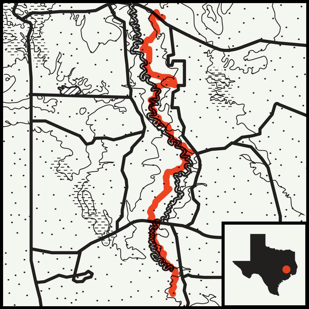
The Piney Woods Hike
Big Thicket National Preserve
Route: Turkey Creek Trail to Pitcher Plant Trail
Distance: 14 miles
Difficulty: Moderate. Hiking the entirety of Turkey Creek will make for a long day, but cutting the trip short at Gore Store Road can save some time.
 While overnighting alone in the Big Thicket National Preserve, I suddenly remembered that the area is believed by many to be the state’s epicenter for Bigfoot. Reported sightings have been common in these parts since the fifties, and today there’s no shortage of blogs and podcasts devoted to the latest Sasquatch news. Not that I’m a believer, but then again, in those far-reaching woods, where hundred-foot pines darken the bottomlands, it at least seems plausible that some corner could shelter a seven-foot-tall apelike creature.
The federal preserve was originally founded, in 1974, to protect the region’s biodiversity, but it has also become a natural playground, with more than forty miles of trails that pad along and around the lower Neches River. (A few months after my visit, some sections were damaged by Hurricane Harvey. We suggest calling park headquarters before planning a trip.)
During my hike along the flowing Turkey Creek, I detoured onto the Pitcher Plant Trail, a mile-long loop, to observe each of the four carnivorous plants that thrive in the Big Thicket (six meat-eating flora exist in the U.S., and only the venus flytrap and cobra lily are missing here). At the south end of Turkey Creek, on my second day, I crossed tea-colored bayous and admired the gnarled bald cypress erupting from the mud. I also encountered a handful of hominids enjoying the forest air, but none of them left footprints larger than mine.
More Hikes
Short Timers
 These great hikes are far from an all-day affair.
Tall Pines Trail, 1.9 miles
Davy Crockett National Forest
This aptly named trail winds through some of the tallest pines in East Texas—and the entire state.
Elm Lake Loop, 1.7 miles
Brazos Bend State Park
There’s plenty to see—alligators, bald cypress draped with Spanish moss, and tons of shoreline birds—along this loop around the swampy Elm Lake.
For even more, check out hikes in North Texas, South & Central Texas, and West Texas.


