


I’ve always loved driving around my home state to see its natural wonders. Whether it’s wading in the Blanco River looking for dinosaur tracks or entering the coolness of one of Texas’s nine thousand caves (as long as it doesn’t involve crawling), there are endless sights to see. As COVID-19 restrictions loosen, this summer is a perfect time to hit the road and hike through canyons, swim in spring-fed pools, and explore . . . volcanoes?
In case you didn’t know, Texas’s fascinatingly diverse geology was formed in no small part by periods of violent volcanism that occurred between about 27 million and 80 million years ago. There are roughly two hundred igneous sites around the state that include a mix of intrusive and extrusive structures, such as calderas, or the collapsed remains of volcanoes that erupted at one point. There is even an extinct volcano in Austin, near where I live, that I never knew existed.
It was the TV series 9-1-1: Lone Star (a pandemic guilty pleasure if ever there was one) that tipped me off to the state’s volcanic past. The now internet-famous episode centered on the eruption of Pilot Knob, a long-extinct (but very real) volcano on the outskirts of Austin, about five miles from my house. The scenes of firefighters saving residents from encroaching lava, flying volcanic rocks, and a hot tub that had turned into a boiling geothermal pool were more cringey than terrifying, but still, the show piqued my curiosity. I was not alone: according to Google Trends, searches for “Austin volcano” peaked in the days after the show aired and viewers expressed mock anxiety on Twitter. The episode left me wondering: What’s the story of volcanoes in Texas?
I reached out to Leon Long, a professor emeritus of geology at the University of Texas at Austin, for answers. For forty years, Long taught a geology field course that included the history of Pilot Knob and the adjacent McKinney Falls State Park, and he knows the area inside out. He assured me that no, there is no chance of Pilot Knob or any other Texas volcanoes becoming active again. “They’re completely dead now, largely eroded or hidden by deposition of younger sediment,” he said, adding ominously that “some associated volcanic centers, such as one near the [Austin] airport, lurk unseen in the subsurface.” But Long still considers Pilot Knob a “geologic wonder,” and he generously offered to meet me there to show me around. Since I was having trouble wrapping my head around the complexities of intrusive versus extrusive volcanism, I was thrilled to have him as my guide.
We met on a rainy Sunday afternoon at the intersection of Dee Gabriel Collins Road and McKinney Falls Parkway, in far southeast Austin—a good spot, Long said, to view Pilot Knob from a distance. (The summit of Pilot Knob is owned by the City of Austin, off-limits to casual visitors.) He emerged from his SUV, holding a clipboard and wearing a well-worn baseball cap that said “Captain Geo.” Undaunted by the drizzle, he set up an impromptu lab in his trunk and for the next hour I got a mini course on Central Texas volcanism. There were charts and maps with clear overlays and even a volcanic rock from Pilot Knob that was 80 million years old.
Pilot Knob appears today as a modest, low-slung hill, but according to Long, it was much bigger when it was “alive,” approximately 80 million years ago. He tried to paint a picture for me: During the Cretaceous period, dinosaurs roamed freely and Texas (along with much of the continent) was submerged under a warm, shallow sea. “Pilot Knob lay partly below and partly above sea level,” he explained. Millions of years of alternating periods of dormancy and activity—when seawater seeped into the throat of the volcano, contacted hot magma, and erupted, blasting fine material into the sky—created a “many-deckered sandwich” of limestone (dormant times) and green volcanic rock (active times). Subsequent erosion has, he said, “excavated a moat into the soft volcanic material, while harder limestone upholds a low encircling escarpment.” Though I didn’t completely grasp the finer points of the geology, I was amazed at how this placid-looking hill had weathered so much upheaval in its very long existence.
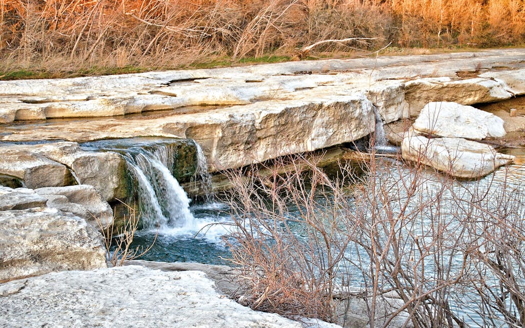
Our next stop was McKinney Falls State Park, a short distance away, to view the lower falls, where Long wanted to show me “spectacular manifestations of Pilot Knob volcanism.” From a path off the small parking area, we began to carefully edge our way down to the falls on a rain-slick apron of limestone that had been deposited on the sloping flank of the volcano, just below sea level at the time. Long pulled a dropper bottle of dilute hydrochloric acid from his bag and had me dribble some on the rock bed, which produced the magic fizz that happens when acid meets calcium carbonate. All around us were ripple marks caused by wave action pushing grains of calcium carbonate back and forth on the shallow seafloor, before everything was cemented into hard rock. Trace fossils, where prehistoric creatures had burrowed many millions of years ago, were everywhere. It felt like walking on the surface of the moon, or, well, a giant lava field.
With Onion Creek roaring over the falls, I nervously clambered after him down slippery rocks (he may be in his late eighties, but I had to hustle to keep up with him) so I could see under the hard limestone lip that upholds the falls, where there is sandwiched at the base a layer of soft, green volcanic material that “blasted into the sky, fell into the sea, and immediately reacted chemically with seawater to transform into clay minerals,” according to Long. There it sits after 80 million years while visitors splashed in the falls’ plunge pool, probably totally unaware that they’re swimming under what was once a volcano.
Before we said goodbye, we hugged, and he pressed a geologic map of the park, now a little soggy, into my hands. Ducking under his SUV’s trunk for cover, we looked a bit longer at his Texas geologic highway map, a must, he emphasized, for anyone who wants to know more about what they’re driving by—either on road trips or in their own neighborhood. I told him I was hoping to get out to West Texas this summer to see more volcanoes. “Big Bend and West Texas are just wonderful for volcanoes!” he exclaimed. “The volcanoes were much more recent, so they’re very striking.” He promised to send me more research material, and I thanked him profusely, inspired to learn more. West Texas road trip, here I come. Now if I could only get Long to tag along.
Where to See Volcanoes in Texas
Before hitting the road, pick up a good field guide, such as Roadside Geology of Texas, by Darwin Spearing. A Texas geological highway map is available at the Bureau of Economic Geology, which has an excellent online store. Far Flung Outdoor Center in Terlingua offers jeep tours of the Big Bend region and will customize itineraries for those especially interested in volcanoes. The following list was created with the generous help of the Bureau of Economic Geology and geologists Linda Ruiz McCall, Pat Dickerson, and Tristan Childress.
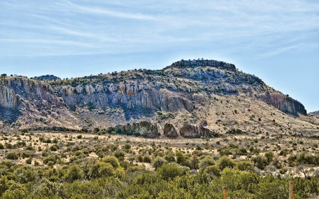
Chisos Volcanic Complex
Location: Big Bend National Park
Volcanism: Lava domes, ash flows, and calderas make for some of the best geology in the state. The western caldera wall rises steeply from the valley floor, and through the Window, an erosional notch in the wall, the grand lava dome of Casa Grande dominates the landscape (see photo).
Highlight: Viewed to the east as sundown approaches, the reddish hue of the rhyolites and ignimbrites adds to the impression of a rugged volcano.
Viewpoint: Ross Maxwell Drive en route to Santa Elena Canyon.
Cornudas Vents
Location: Texas–New Mexico border, near Dell City
Volcanism: Between 31 and 35 million years old, this striking cluster of “intrusive alkaline igneous bodies” (formed underground and exposed by erosion over time) rises out of the Chihuahuan Desert.
Highlight: From Dell City, you can also see El Capitan to the east (it’s magnificent at sunrise).
Viewpoint: The best physical access point to the mountains is from the New Mexico side, but they can be viewed on U.S. 62, driving west toward El Paso.
Davis Mountains
Location: Fort Davis
Volcanism: The 35-million-year-old Davis Mountains are formed by magma from two volcanic centers—the Paisano Volcano, west of Alpine, and the Buckhorn Caldera, northwest of Fort Davis.
Highlight: Limpia Canyon and Wild Rose Pass provide excellent exposures of the varied and extensive flows and pyroclastic strata.
Viewpoint: The 75-mile scenic drive on Texas highways 118 and 161 through the mountains. Also the hiking trail from Davis Mountains State Park to the Fort Davis National Historic Site. Cliffs of tuff form the backdrop to the old fort.
Mitre Peak
Location: Eleven miles west of Fort Davis
Volcanism: This freestanding intrusive mountain contains 35-million-year-old rhyolite lava from the Davis Mountains complex and has been sculpted over time by erosion.
Highlight: Its distinctive shape resembles a bishop’s mitre (headgear), from which it takes its name.
Viewpoint: Clayton’s Overlook at Chihuahuan Desert Nature Center.
Paisano Pass
Location: U.S. 90 between Alpine and Marfa
Volcanism: As you drive over the collapsed crater of the Paisano Volcano, which erupted about 35 million years ago, you can see light-colored syenite, which resembles granite. Rhyolite lava (“paisanite”) from an earlier eruption is exposed in nearby highway roadcuts.
Highlight: Be sure to check out the information display at the rest area on U.S. 90, erected by the Big Bend Snapshot of History Project, which includes a QR code to access photos and videos about the area’s geology.
Pilot Knob
Location: Southeast Austin, not far from Austin Bergstrom International Airport.
Volcanism: Pilot Knob was part of the Balcones group of volcanoes that once stretched from Waco to Uvalde (many are underground).
Viewpoint: Intersection of Dee Gabriel Collins Road and McKinney Falls Parkway.
Quitman Mountains Caldera Complex
Location: Hudspeth County
Volcanism: This series of calderas dates back to the Eocene (35 million years ago) and includes intrusive as well as volcanic rocks. Distinctive folds of sedimentary strata loom high above the desert.
Highlight: Craggy volcanic peaks interrupt the long linear folds of lighter-colored Cretaceous sedimentary rocks.
Viewpoint: Driving west from Van Horn on Interstate 10, the distinctive sedimentary folds and rocks of this volcanic mountain range rise up dramatically. This stretch of highway also takes you past the Eagle Mountain caldera.
Three Dike Hill
Location: Southernmost Big Bend Ranch State Park
Volcanism: At this 27-million-year-old site, dark basalt dikes cut up through varicolored softer tuff layers to feed lava flows at the top of the hill. You’ll also get a clear view of a feeder dike that delivered basalt to the upper lava flow.
Highlight: In his book El Camino del Rio: The River Road, the late naturalist, author, and Big Bend Ranch tour guide David Alloway described this site as looking like “fingers of dark rock rising vertically through buff volcanic ash.”
Viewpoint: Travel west from Lajitas on the River Road (FM 170), until you see highway signs for Arenosa Campground. Continue west from the campground for 3.6 miles more; the pullout and parking area for Three Dike Hill are on the northeast side of FM 170.
Tuff Canyon
Location: Big Bend National Park
Volcanism: Here you can see basalt lava rocks and pyroclastic debris (or fiery pieces, including the namesake “tuff” or hardened volcanic ash) that were expelled from the Chisos volcanoes 29–30 million years ago.
Highlight: Marvel at the volcanic glass that’s melted into rock draperies.
Viewpoint: There’s a pullout and parking lot with several accessible viewpoints. Choose from short, family-friendly hikes and longer walks to the canyon floor.
Uvalde Volcanoes
Location: U.S. 90 between Knippa and Brackettville
Volcanism: Volcanic eruptions were plentiful in the Texas Hill Country during the Cretaceous period, at around the same time as Pilot Knob. A number of lava bodies can still be seen in the Uvalde area. They include two prominent volcanic domes at Knippa; Mount Inge, a volcanic plug near historic Fort Inge, and a roadcut three miles west of Sabinal, where you can see dark volcanic breccia rocks weathered by white caliche.
Highlight: Mount Inge is a broad, dark dome (elevation 140 feet) that presides over the state historical park.
Viewpoint: Fort Inge Historical Park, a mile south of Uvalde.
- More About:
- Uvalde
- Fort Davis
- Big Bend
- Austin


